CountyAtlas Arkansas
Arkansas County Map with Cities — All 75 Counties
All 75 of Arkansas's counties, mapped from official U.S. Census boundaries with population, income, and unemployment for every one. Colour the map by any measure, tap a county for its data, or download a print-ready copy.
Tap any county for its population, income, and more.
Arkansas at a glance
- Scale. Arkansas is divided into 75 counties across 51,992 sq mi of land — an average of 693 sq mi each. Census TIGER
- People. Its counties are home to 3,067,732 residents — an average of 40,903 each, or 59 per square mile statewide. Census PEP 2023
- Water. Another 1,206 sq mi is water — 2.3% of the state’s area, led by Desha County. Census TIGER
Arkansas’s 75 counties, by the numbers
Every county’s population, median household income, unemployment, density, and land area — sortable by any column, so you can find yours or rank by what matters to you. A few patterns run through the data:
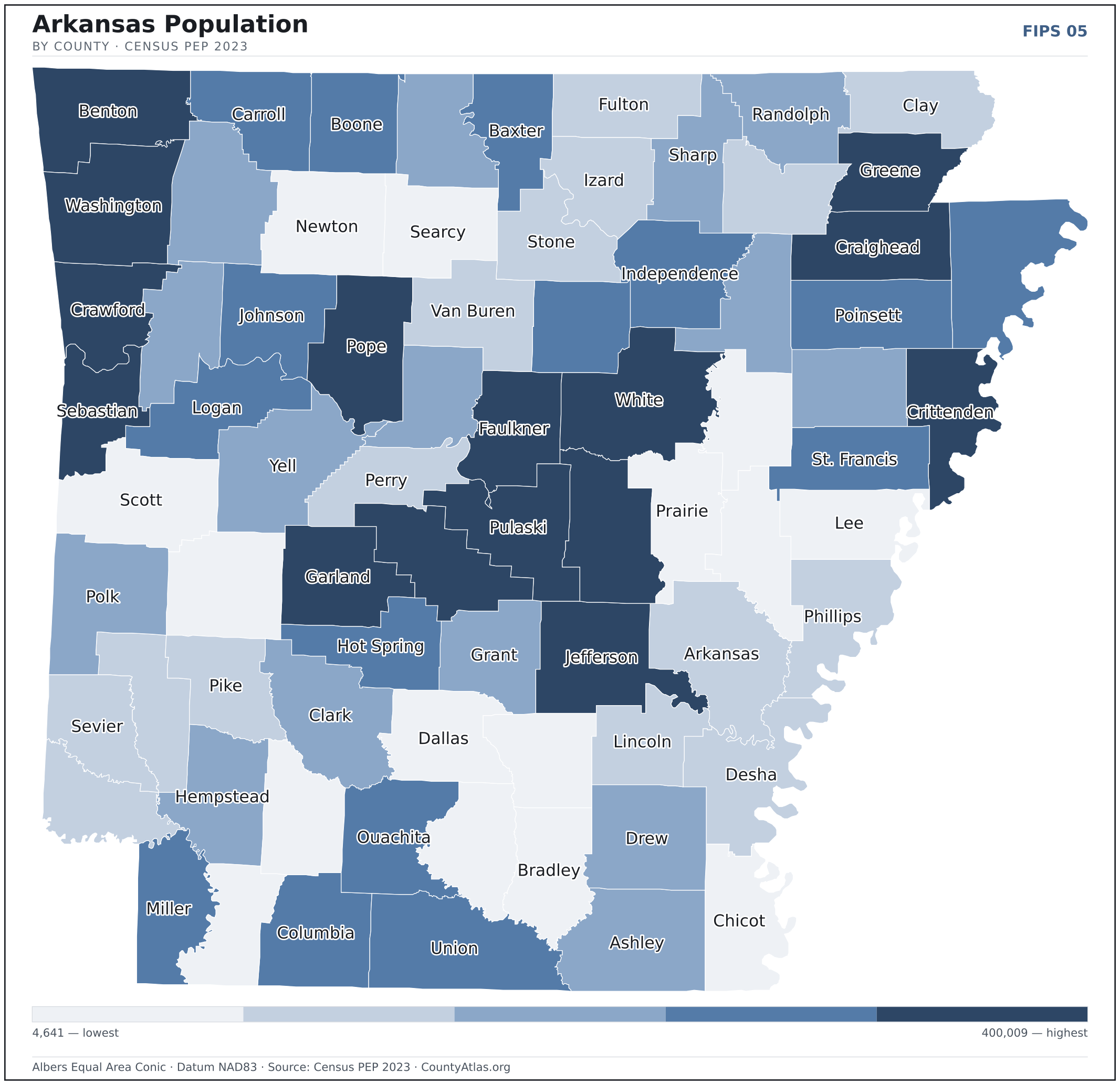
- Concentrated. Half of Arkansas’s 3,067,732 residents live in just 8 of 75 counties, and the five largest hold 40.2% of the total. Census PEP 2023
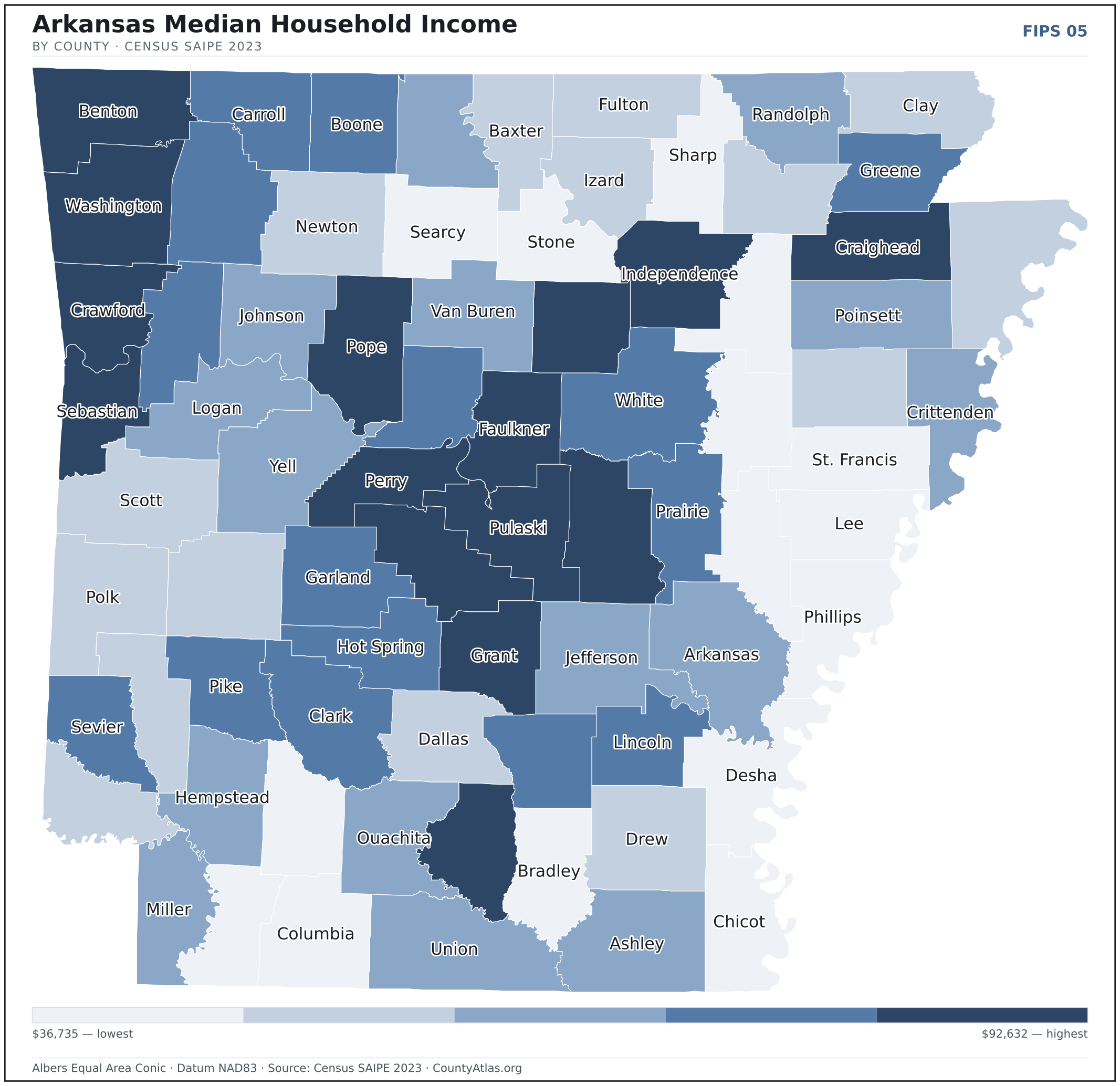
- Income tracks poverty. The gap from richest to poorest runs 2.5×, and the 10 highest-income counties average 12.3% in poverty against 27.3% for the 10 lowest. Census SAIPE 2023
- Mostly small. Half of Arkansas’s counties have fewer than 18,262 residents, and half report a median household income below $50,387 — a few metros lift the statewide totals well above both. Census PEP 2023 · SAIPE 2023
- Lopsided density. Only 18 of 75 counties are denser than Arkansas’s statewide average of 59 people per square mile — the rest are more rural. Census PEP 2023 · TIGER
| Arkansas County | 16,307 | $50,198 | 4.3% | 16/sq mi | 992 sq mi | DeWitt; Stuttgart |
| Ashley County | 18,262 | $49,560 | 5.1% | 20/sq mi | 925 sq mi | Hamburg |
| Baxter County | 42,875 | $48,804 | 4.0% | 77/sq mi | 554 sq mi | Mountain Home |
| Benton County | 311,013 | $92,632 | 2.9% | 367/sq mi | 848 sq mi | Bentonville |
| Boone County | 38,530 | $56,154 | 3.5% | 65/sq mi | 590 sq mi | Harrison |
| Bradley County | 10,104 | $44,525 | 4.9% | 16/sq mi | 649 sq mi | Warren |
| Calhoun County | 4,641 | $57,689 | 3.5% | 7/sq mi | 629 sq mi | Hampton |
| Carroll County | 28,814 | $53,986 | 3.5% | 46/sq mi | 630 sq mi | Berryville; Eureka Springs |
| Chicot County | 9,538 | $40,381 | 5.9% | 15/sq mi | 637 sq mi | Lake Village |
| Clark County | 21,274 | $53,561 | 4.1% | 25/sq mi | 866 sq mi | Arkadelphia |
| Clay County | 14,201 | $47,663 | 3.7% | 22/sq mi | 639 sq mi | Corning; Piggott |
| Cleburne County | 25,445 | $56,692 | 4.3% | 46/sq mi | 554 sq mi | Heber Springs |
| Cleveland County | 7,378 | $54,458 | 4.1% | 12/sq mi | 598 sq mi | Rison |
| Columbia County | 22,150 | $44,175 | 4.4% | 29/sq mi | 766 sq mi | Magnolia |
| Conway County | 21,077 | $53,863 | 3.9% | 38/sq mi | 552 sq mi | Morrilton |
| Craighead County | 113,993 | $60,204 | 3.5% | 161/sq mi | 707 sq mi | Jonesboro; Lake City |
| Crawford County | 61,891 | $63,905 | 3.8% | 104/sq mi | 595 sq mi | Van Buren |
| Crittenden County | 47,139 | $52,153 | 4.9% | 77/sq mi | 612 sq mi | Marion |
| Cross County | 16,420 | $47,669 | 3.8% | 27/sq mi | 616 sq mi | Wynne |
| Dallas County | 6,185 | $46,701 | 4.3% | 9/sq mi | 667 sq mi | Fordyce |
| Desha County | 10,479 | $43,469 | 6.6% | 14/sq mi | 741 sq mi | Arkansas City |
| Drew County | 16,945 | $48,746 | 4.3% | 20/sq mi | 829 sq mi | Monticello |
| Faulkner County | 129,951 | $68,543 | 3.5% | 201/sq mi | 647 sq mi | Conway |
| Franklin County | 17,468 | $54,077 | 3.9% | 29/sq mi | 609 sq mi | Charleston; Ozark |
| Fulton County | 12,421 | $46,346 | 4.4% | 20/sq mi | 618 sq mi | Salem |
| Garland County | 99,784 | $53,849 | 3.8% | 147/sq mi | 678 sq mi | Hot Springs |
| Grant County | 18,383 | $64,306 | 3.2% | 29/sq mi | 632 sq mi | Sheridan |
| Greene County | 46,743 | $55,444 | 4.2% | 81/sq mi | 577 sq mi | Paragould |
| Hempstead County | 19,343 | $50,576 | 3.9% | 27/sq mi | 727 sq mi | Hope |
| Hot Spring County | 33,258 | $53,767 | 4.1% | 54/sq mi | 615 sq mi | Malvern |
| Howard County | 12,533 | $47,308 | 4.5% | 21/sq mi | 587 sq mi | Nashville |
| Independence County | 38,320 | $59,695 | 3.2% | 50/sq mi | 764 sq mi | Batesville |
| Izard County | 14,169 | $47,320 | 5.4% | 24/sq mi | 580 sq mi | Melbourne |
| Jackson County | 16,784 | $45,762 | 3.6% | 26/sq mi | 634 sq mi | Newport |
| Jefferson County | 63,661 | $49,581 | 5.7% | 73/sq mi | 872 sq mi | Pine Bluff |
| Johnson County | 26,129 | $50,387 | 5.0% | 40/sq mi | 661 sq mi | Clarksville |
| Lafayette County | 6,095 | $43,824 | 4.1% | 12/sq mi | 529 sq mi | Lewisville |
| Lawrence County | 16,318 | $49,015 | 3.8% | 28/sq mi | 588 sq mi | Walnut Ridge |
| Lee County | 8,201 | $36,735 | 5.2% | 14/sq mi | 600 sq mi | Marianna |
| Lincoln County | 12,898 | $53,381 | 5.1% | 23/sq mi | 559 sq mi | Star City |
| Little River County | 11,805 | $48,837 | 3.8% | 22/sq mi | 531 sq mi | Ashdown |
| Logan County | 21,400 | $51,290 | 3.7% | 30/sq mi | 709 sq mi | Booneville; Paris |
| Lonoke County | 75,944 | $74,687 | 3.3% | 98/sq mi | 772 sq mi | Lonoke |
| Madison County | 17,775 | $52,262 | 2.9% | 21/sq mi | 834 sq mi | Huntsville |
| Marion County | 17,514 | $49,975 | 5.1% | 29/sq mi | 597 sq mi | Yellville |
| Miller County | 42,415 | $50,421 | 4.4% | 68/sq mi | 624 sq mi | Texarkana |
| Mississippi County | 38,663 | $49,484 | 4.1% | 43/sq mi | 902 sq mi | Blytheville; Osceola |
| Monroe County | 6,512 | $40,631 | 4.9% | 11/sq mi | 607 sq mi | Clarendon |
| Montgomery County | 8,620 | $48,991 | 4.3% | 11/sq mi | 780 sq mi | Mount Ida |
| Nevada County | 8,120 | $45,562 | 5.3% | 13/sq mi | 618 sq mi | Prescott |
| Newton County | 7,071 | $46,307 | 4.0% | 9/sq mi | 821 sq mi | Jasper |
| Ouachita County | 21,793 | $49,690 | 4.4% | 30/sq mi | 733 sq mi | Camden |
| Perry County | 10,184 | $57,996 | 4.2% | 18/sq mi | 551 sq mi | Perryville |
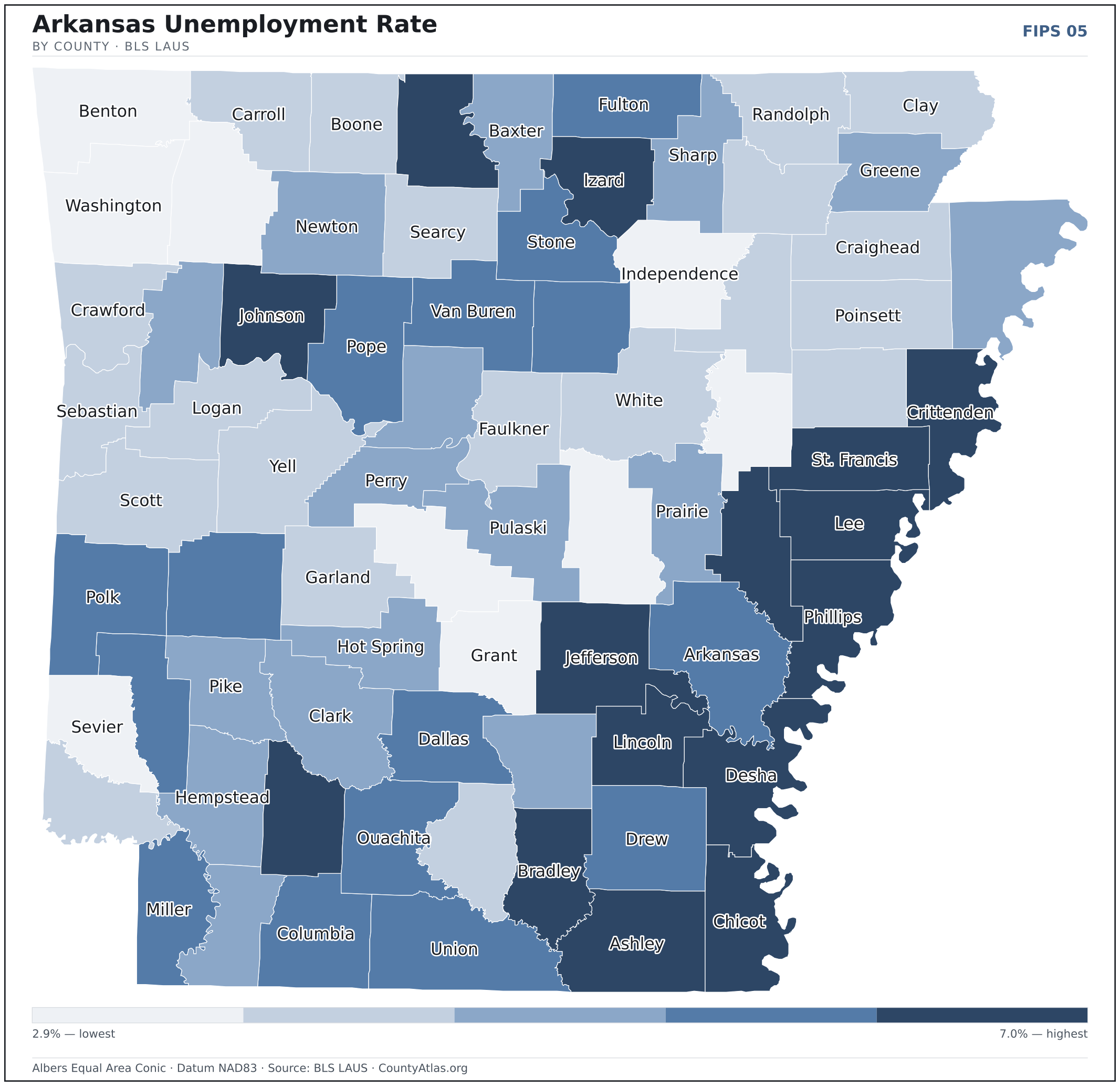
| Phillips County | 14,961 | $37,338 | 7.0% | 22/sq mi | 690 sq mi | Helena-West Helena |
| Pike County | 10,208 | $53,108 | 4.1% | 17/sq mi | 600 sq mi | Murfreesboro |
| Poinsett County | 22,397 | $51,635 | 3.8% | 30/sq mi | 758 sq mi | Harrisburg |
| Polk County | 19,436 | $47,766 | 4.3% | 23/sq mi | 857 sq mi | Mena |
| Pope County | 64,593 | $59,016 | 4.5% | 80/sq mi | 811 sq mi | Russellville |
| Prairie County | 8,036 | $54,962 | 4.0% | 12/sq mi | 648 sq mi | De Valls Bluff; Des Arc |
| Pulaski County | 400,009 | $61,344 | 4.0% | 527/sq mi | 758 sq mi | Little Rock |
| Randolph County | 18,907 | $51,480 | 3.5% | 29/sq mi | 652 sq mi | Pocahontas |
| Saline County | 129,574 | $77,844 | 3.2% | 179/sq mi | 724 sq mi | Benton |
| Scott County | 9,851 | $46,026 | 3.7% | 11/sq mi | 893 sq mi | Waldron |
| Searcy County | 7,806 | $40,688 | 3.5% | 12/sq mi | 666 sq mi | Marshall |
| Sebastian County | 129,098 | $58,112 | 3.7% | 243/sq mi | 531 sq mi | Fort Smith; Greenwood |
| Sevier County | 15,632 | $52,845 | 3.0% | 28/sq mi | 564 sq mi | De Queen |
| Sharp County | 17,968 | $45,258 | 4.0% | 30/sq mi | 605 sq mi | Ash Flat |
| St. Francis County | 22,101 | $41,708 | 4.9% | 35/sq mi | 635 sq mi | Forrest City |
| Stone County | 12,671 | $43,767 | 4.8% | 21/sq mi | 606 sq mi | Mountain View |
| Union County | 37,397 | $49,664 | 4.5% | 36/sq mi | 1,039 sq mi | El Dorado |
| Van Buren County | 16,142 | $50,332 | 4.6% | 23/sq mi | 710 sq mi | Clinton |
| Washington County | 261,549 | $66,158 | 3.0% | 278/sq mi | 941 sq mi | Fayetteville |
| White County | 78,452 | $56,178 | 3.7% | 76/sq mi | 1,034 sq mi | Searcy |
| Woodruff County | 5,964 | $43,259 | 3.3% | 10/sq mi | 586 sq mi | Augusta |
| Yell County | 20,044 | $51,997 | 3.8% | 22/sq mi | 930 sq mi | Danville; Dardanelle |
All 75 counties, sortable by any column — click a heading. A suppressed estimate (coefficient of variation ≥ 0.30) shows a marker, never a guess. County seats are from Wikidata (CC0), each validated to a Census place inside its county; a county with no validated seat is left blank. See the methodology.
Download & print this Arkansas map
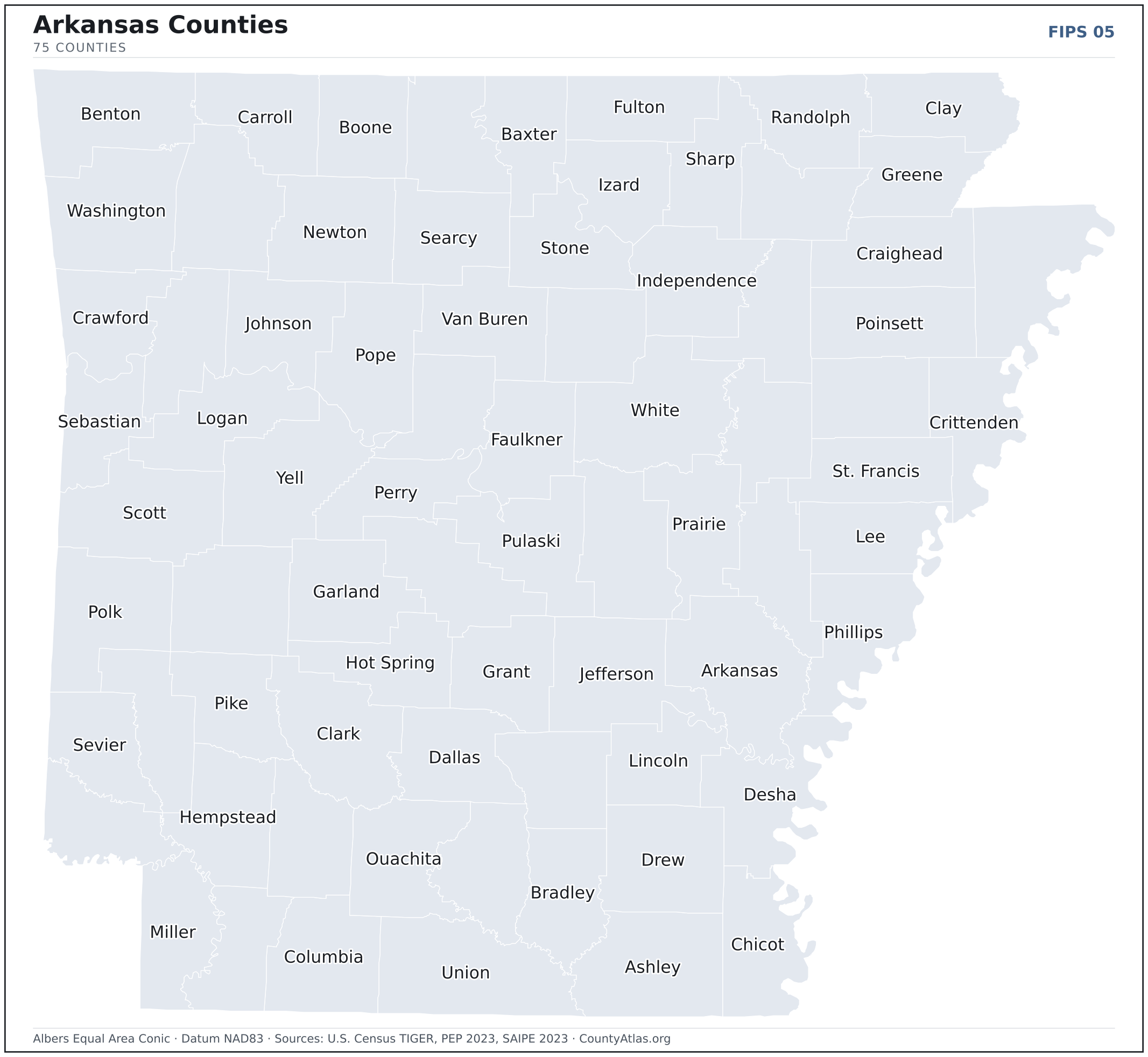
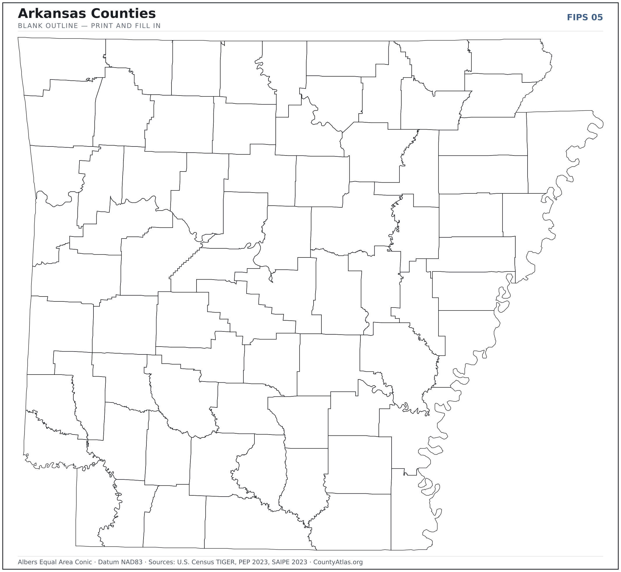
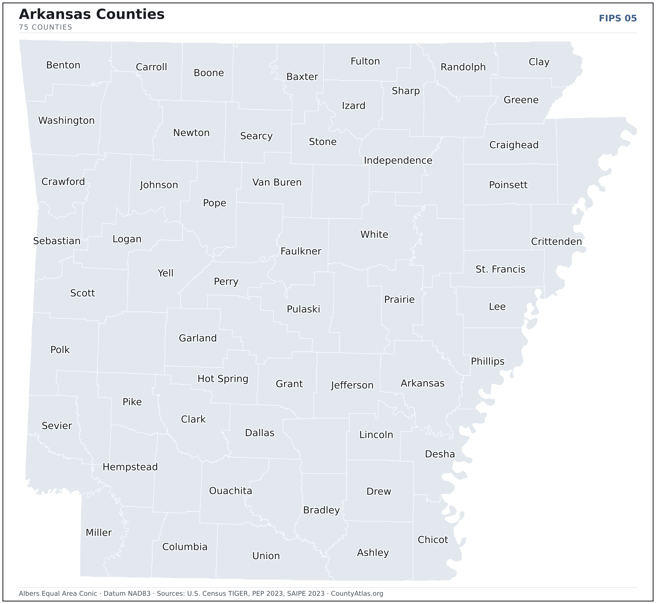
Arkansas maps, coloured by the data
Cities in Arkansas
Arkansas has 501 incorporated cities and towns. The largest is Little Rock in Pulaski County with 202,739 residents. Use the search on the map above to find any city and highlight the county it sits in.
| Little Rock | Pulaski County | 202,739 |
| Fayetteville | Washington County | 97,227 |
| Fort Smith | Sebastian County | 89,496 |
| Springdale | Washington County | 87,388 |
| Jonesboro | Craighead County | 79,187 |
| Rogers | Benton County | 71,411 |
| Conway | Faulkner County | 66,288 |
| North Little Rock | Pulaski County | 64,504 |
| Bentonville | Benton County | 56,326 |
| Pine Bluff | Jefferson County | 40,436 |
| Hot Springs | Garland County | 38,023 |
| Benton | Saline County | 35,954 |
| Sherwood | Pulaski County | 32,915 |
| Bella Vista | Benton County | 30,935 |
| Paragould | Greene County | 29,940 |
| Texarkana | Miller County | 29,343 |
| Jacksonville | Pulaski County | 29,285 |
| Russellville | Pope County | 29,057 |
| Cabot | Lonoke County | 26,733 |
| West Memphis | Crittenden County | 24,147 |
| Van Buren | Crawford County | 23,545 |
| Searcy | White County | 23,115 |
| Bryant | Saline County | 21,125 |
| Centerton | Benton County | 20,212 |
| Maumelle | Pulaski County | 19,286 |
| Siloam Springs | Benton County | 18,096 |
| El Dorado | Union County | 17,382 |
| Marion | Crittenden County | 13,641 |
| Harrison | Boone County | 13,217 |
| Blytheville | Mississippi County | 13,026 |
| Mountain Home | Baxter County | 13,021 |
| Forrest City | St. Francis County | 12,826 |
| Batesville | Independence County | 11,385 |
| Magnolia | Columbia County | 10,973 |
| Malvern | Hot Spring County | 10,938 |
| Lowell | Benton County | 10,438 |
| Camden | Ouachita County | 10,427 |
| Arkadelphia | Clark County | 10,316 |
| Greenwood | Sebastian County | 9,570 |
| Clarksville | Johnson County | 9,500 |
| Helena-West Helena | Phillips County | 9,218 |
| Hope | Hempstead County | 8,787 |
| Beebe | White County | 8,580 |
| Farmington | Washington County | 8,469 |
| Monticello | Drew County | 8,320 |
| Wynne | Cross County | 8,220 |
| Stuttgart | Arkansas County | 8,060 |
| Newport | Jackson County | 8,019 |
| Pocahontas | Randolph County | 7,475 |
| Prairie Grove | Washington County | 7,445 |
Showing the 50 most populous — and 451 more. Search the map above for any Arkansas city or village.
A city can span more than one county; each is listed in its primary county — the one its center falls in.
Which Arkansas county is the richest, largest, most crowded? The answers
- Arkansas’s highest median household income is in Benton County ($92,632); the lowest is in Lee County ($36,735). Census SAIPE 2023
- Arkansas’s most populous county is Pulaski County (400,009); the least populous is Calhoun County (4,641) — a 86× spread. Census PEP 2023
- Arkansas’s largest county by land area is Union County (1,039 sq mi); the smallest is Lafayette County (529 sq mi). Census TIGER
- Arkansas’s highest population density is in Pulaski County (527/sq mi); the lowest is in Calhoun County (7/sq mi). Census PEP 2023 · TIGER
- Arkansas’s highest poverty rate is in Lee County (38.7%); the lowest is in Benton County (7.8%). Census SAIPE 2023
- In Arkansas, unemployment is highest in Phillips County (7.0%) and lowest in Benton County (2.9%), for May 2026. BLS LAUS
- Arkansas’s highest median age is in Baxter County (51.9); the lowest is in Clark County (31.9). Census ACS 2019–2023
- Arkansas’s highest share of bachelor’s degrees is in Pulaski County (37.4% of adults); the lowest is in Lee County (6.9%). Census ACS 2019–2023
Every figure is a current official estimate from the source named — not a crowd-sourced or copied value. Suppressed estimates (coefficient of variation ≥ 0.30) are omitted, never guessed. See the full methodology.
Arkansas counties: common questions
How many counties are in Arkansas?
Arkansas has 75 counties covering 51,992 sq mi and about 3.1M residents. Every one is on the map above and in the table below.
What is the largest county in Arkansas?
It depends on the measure. By land area it’s Union County (1,039 sq mi); by population it’s Pulaski County (400,009 residents).
What county is Little Rock in?
Little Rock (population 202,739) is in Pulaski County. Use the search on the map to find any Arkansas city’s county.
What is the richest county in Arkansas?
By median household income, Benton County is the richest at $92,632; the poorest is Lee County at $36,735 (Census SAIPE 2023).
What is the most populous county in Arkansas?
Pulaski County, with 400,009 residents — about 13.0% of Arkansas’s people, and 86× the least populous, Calhoun County (4,641).
Sources & vintages
- Population — PEP Vintage 2023 (July 1, 2023) — pep/charv
- Median household income & poverty — SAIPE 2023
- Unemployment — BLS LAUS May 2026 (preliminary)
- Geometry & boundaries — Census TIGERweb
- Cities & city population — Census TIGERweb Incorporated Places + ACS 5-year 2019–2023
Data current through .