CountyAtlas Idaho
Idaho County Map with Cities — All 44 Counties
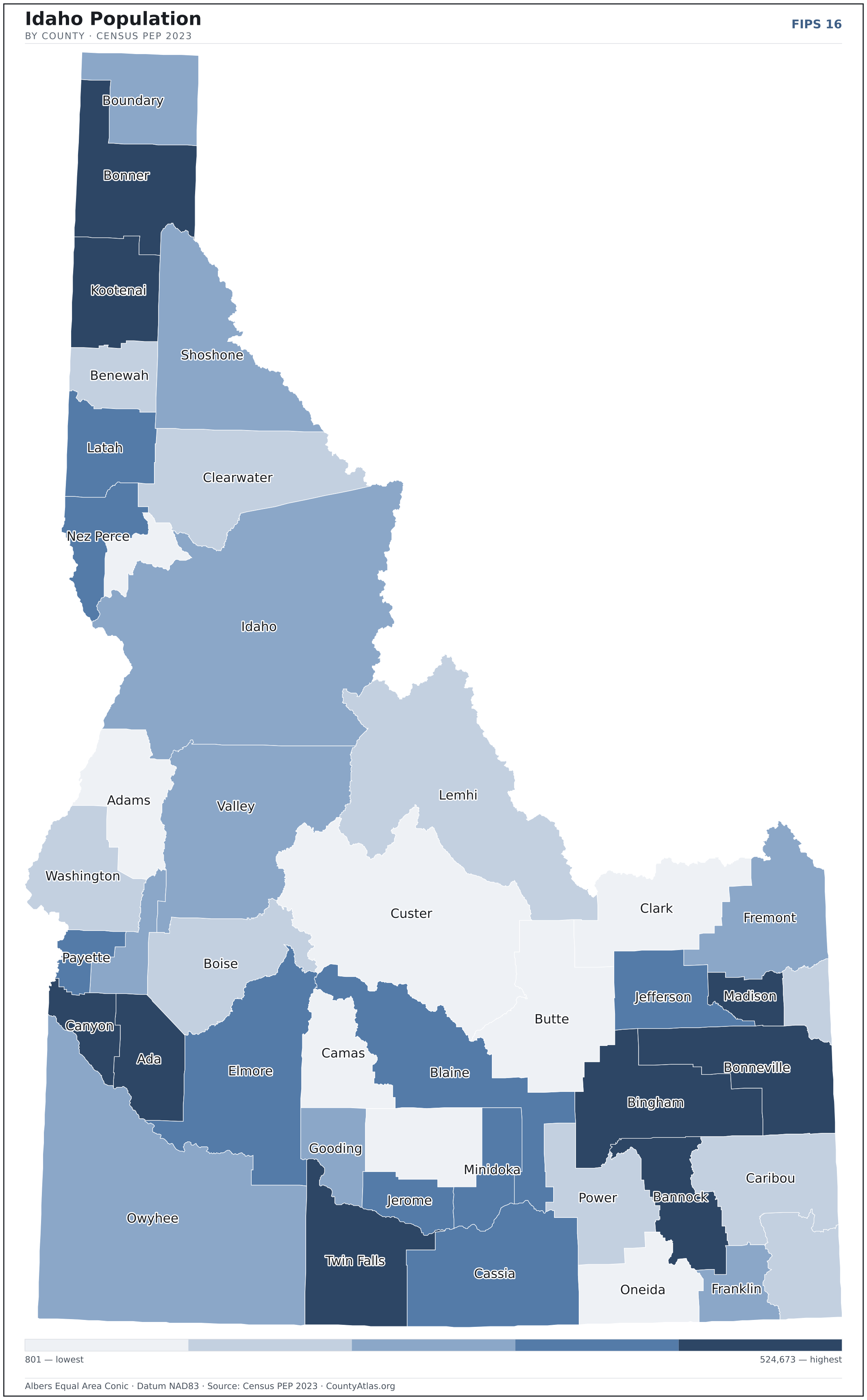
All 44 of Idaho's counties, mapped from official U.S. Census boundaries with population, income, and unemployment for every one. Colour the map by any measure, tap a county for its data, or download a print-ready copy.
Tap any county for its population, income, and more.
Idaho at a glance
- Scale. Idaho is divided into 44 counties across 82,645 sq mi of land — an average of 1,878 sq mi each. Census TIGER
- People. Its counties are home to 1,964,726 residents — an average of 44,653 each, or 24 per square mile statewide. Census PEP 2023
- Water. Another 923 sq mi is water — 1.1% of the state’s area, led by Bonner County. Census TIGER
Idaho’s 44 counties, by the numbers
Every county’s population, median household income, unemployment, density, and land area — sortable by any column, so you can find yours or rank by what matters to you. A few patterns run through the data:
- Concentrated. Half of Idaho’s 1,964,726 residents live in just 4 of 44 counties, and the five largest hold 60.8% of the total. Census PEP 2023
- Income tracks poverty. The gap from richest to poorest runs 1.8×, and the 10 highest-income counties average 8.5% in poverty against 14.6% for the 10 lowest. Census SAIPE 2023
- Mostly small. Half of Idaho’s counties have fewer than 14,845 residents, and half report a median household income below $67,254 — a few metros lift the statewide totals well above both. Census PEP 2023 · SAIPE 2023
- Lopsided density. Only 17 of 44 counties are denser than Idaho’s statewide average of 24 people per square mile — the rest are more rural. Census PEP 2023 · TIGER
| Ada County | 524,673 | $90,513 | 3.2% | 499/sq mi | 1,052 sq mi | Boise City |
| Adams County | 4,903 | $59,829 | 6.3% | 4/sq mi | 1,363 sq mi | Council |
| Bannock County | 90,400 | $67,371 | 4.1% | 81/sq mi | 1,112 sq mi | Pocatello |
| Bear Lake County | 6,766 | $67,519 | 3.0% | 7/sq mi | 976 sq mi | Paris |
| Benewah County | 10,369 | $60,872 | 4.8% | 13/sq mi | 777 sq mi | St. Maries |
| Bingham County | 50,395 | $73,409 | 3.3% | 24/sq mi | 2,094 sq mi | Blackfoot |
| Blaine County | 25,041 | $94,471 | 3.3% | 9/sq mi | 2,638 sq mi | Hailey |
| Boise County | 8,517 | $74,433 | 3.8% | 4/sq mi | 1,899 sq mi | Idaho City |
| Bonner County | 52,547 | $68,030 | 4.9% | 30/sq mi | 1,733 sq mi | Sandpoint |
| Bonneville County | 131,366 | $74,948 | 3.2% | 70/sq mi | 1,866 sq mi | Idaho Falls |
| Boundary County | 13,557 | $65,044 | 4.6% | 11/sq mi | 1,269 sq mi | Bonners Ferry |
| Butte County | 2,758 | $57,678 | 3.8% | 1/sq mi | 2,236 sq mi | Arco |
| Camas County | 1,232 | $72,175 | 3.8% | 1/sq mi | 1,074 sq mi | Fairfield |
| Canyon County | 257,674 | $72,059 | 3.4% | 439/sq mi | 587 sq mi | Caldwell |
| Caribou County | 7,219 | $70,183 | 3.5% | 4/sq mi | 1,764 sq mi | Soda Springs |
| Cassia County | 25,696 | $68,267 | 3.2% | 10/sq mi | 2,566 sq mi | Burley |
| Clark County | 801 | $55,625 | 3.7% | 0/sq mi | 1,763 sq mi | Dubois |
| Clearwater County | 9,214 | $58,757 | 5.7% | 4/sq mi | 2,453 sq mi | Orofino |
| Custer County | 4,523 | $58,294 | 4.3% | 1/sq mi | 4,922 sq mi | Challis |
| Elmore County | 29,724 | $64,247 | 3.8% | 10/sq mi | 3,075 sq mi | Mountain Home |
| Franklin County | 15,494 | $80,768 | 3.1% | 23/sq mi | 663 sq mi | Preston |
| Fremont County | 14,196 | $72,061 | 3.0% | 8/sq mi | 1,864 sq mi | St. Anthony |
| Gem County | 21,071 | $62,479 | 3.6% | 38/sq mi | 560 sq mi | Emmett |
| Gooding County | 16,061 | $65,662 | 3.1% | 22/sq mi | 729 sq mi | Gooding |
| Idaho County | 17,890 | $57,210 | 4.1% | 2/sq mi | 8,478 sq mi | Grangeville |
| Jefferson County | 34,198 | $81,566 | 2.9% | 31/sq mi | 1,094 sq mi | Rigby |
| Jerome County | 25,479 | $62,543 | 3.0% | 43/sq mi | 598 sq mi | Jerome |
| Kootenai County | 185,010 | $75,235 | 4.0% | 149/sq mi | 1,238 sq mi | Coeur d'Alene |
| Latah County | 41,301 | $63,916 | 3.1% | 38/sq mi | 1,080 sq mi | Moscow |
| Lemhi County | 8,441 | $57,562 | 3.8% | 2/sq mi | 4,564 sq mi | Salmon |
| Lewis County | 3,739 | $53,212 | 4.3% | 8/sq mi | 479 sq mi | Nezperce |
| Lincoln County | 5,450 | $65,511 | 3.6% | 5/sq mi | 1,201 sq mi | Shoshone |
| Madison County | 54,547 | $58,236 | 3.8% | 116/sq mi | 469 sq mi | Rexburg |
| Minidoka County | 22,480 | $68,029 | 3.4% | 30/sq mi | 757 sq mi | Rupert |
| Nez Perce County | 42,987 | $70,340 | 3.4% | 51/sq mi | 848 sq mi | Lewiston |
| Oneida County | 4,953 | $67,137 | 2.7% | 4/sq mi | 1,199 sq mi | Malad City |
| Owyhee County | 12,722 | $60,701 | 3.6% | 2/sq mi | 7,668 sq mi | Murphy |
| Payette County | 27,279 | $67,532 | 4.1% | 67/sq mi | 407 sq mi | Payette |
| Power County | 8,253 | $68,403 | 2.9% | 6/sq mi | 1,404 sq mi | American Falls |
| Shoshone County | 14,026 | $59,937 | 4.6% | 5/sq mi | 2,638 sq mi | Wallace |
| Teton County | 12,549 | $94,895 | 2.9% | 28/sq mi | 449 sq mi | Driggs |
| Twin Falls County | 95,156 | $66,664 | 3.2% | 50/sq mi | 1,922 sq mi | Twin Falls |
| Valley County | 12,644 | $84,024 | 4.2% | 3/sq mi | 3,665 sq mi | Cascade |
| Washington County | 11,425 | $57,369 | 4.3% | 8/sq mi | 1,453 sq mi | Weiser |
All 44 counties, sortable by any column — click a heading. A suppressed estimate (coefficient of variation ≥ 0.30) shows a marker, never a guess. County seats are from Wikidata (CC0), each validated to a Census place inside its county; a county with no validated seat is left blank. See the methodology.
Download & print this Idaho map
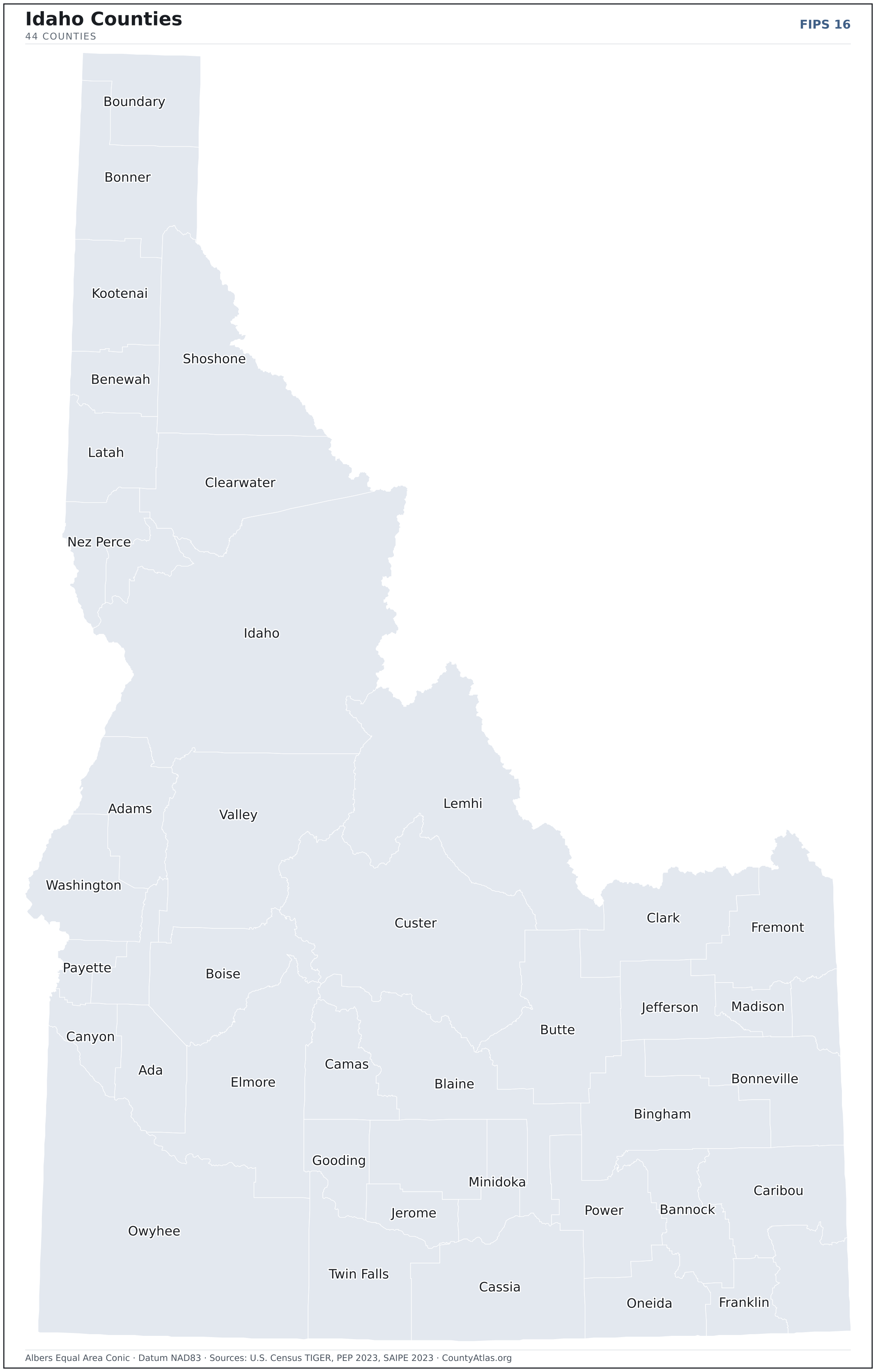
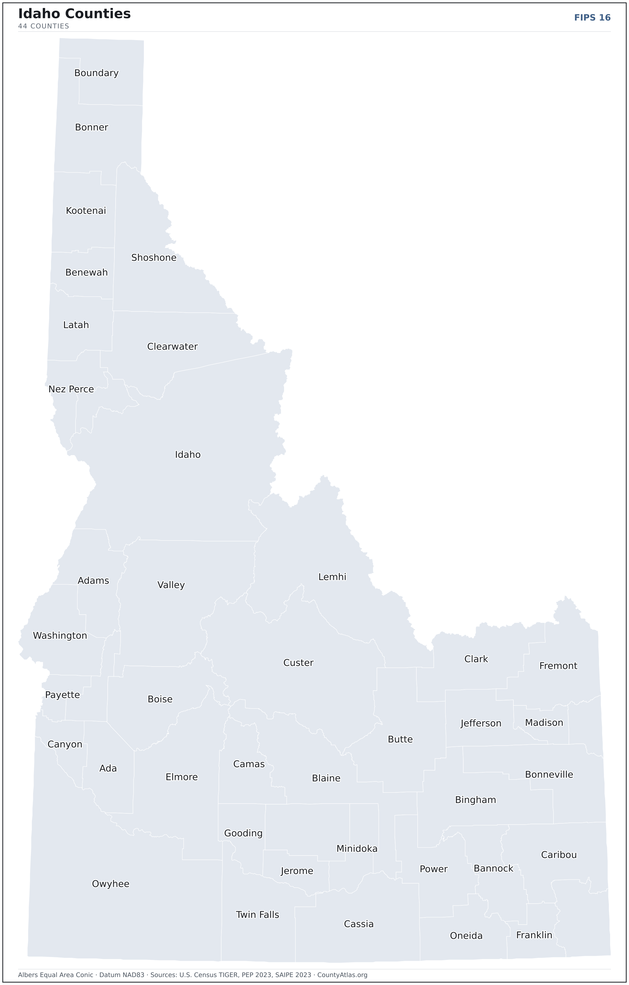
Idaho maps, coloured by the data
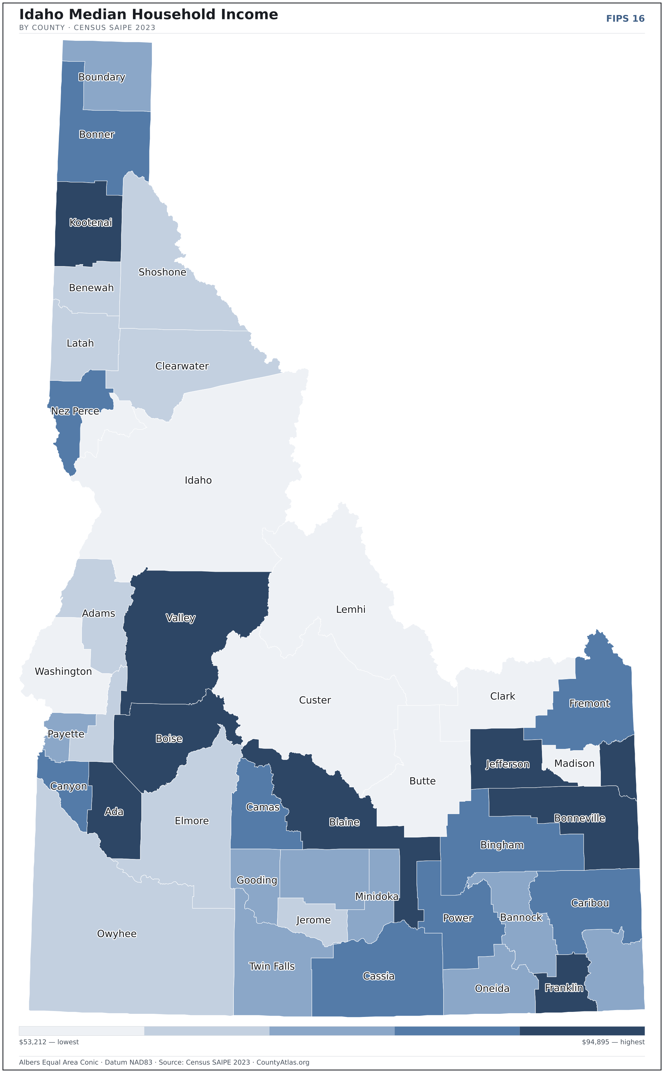
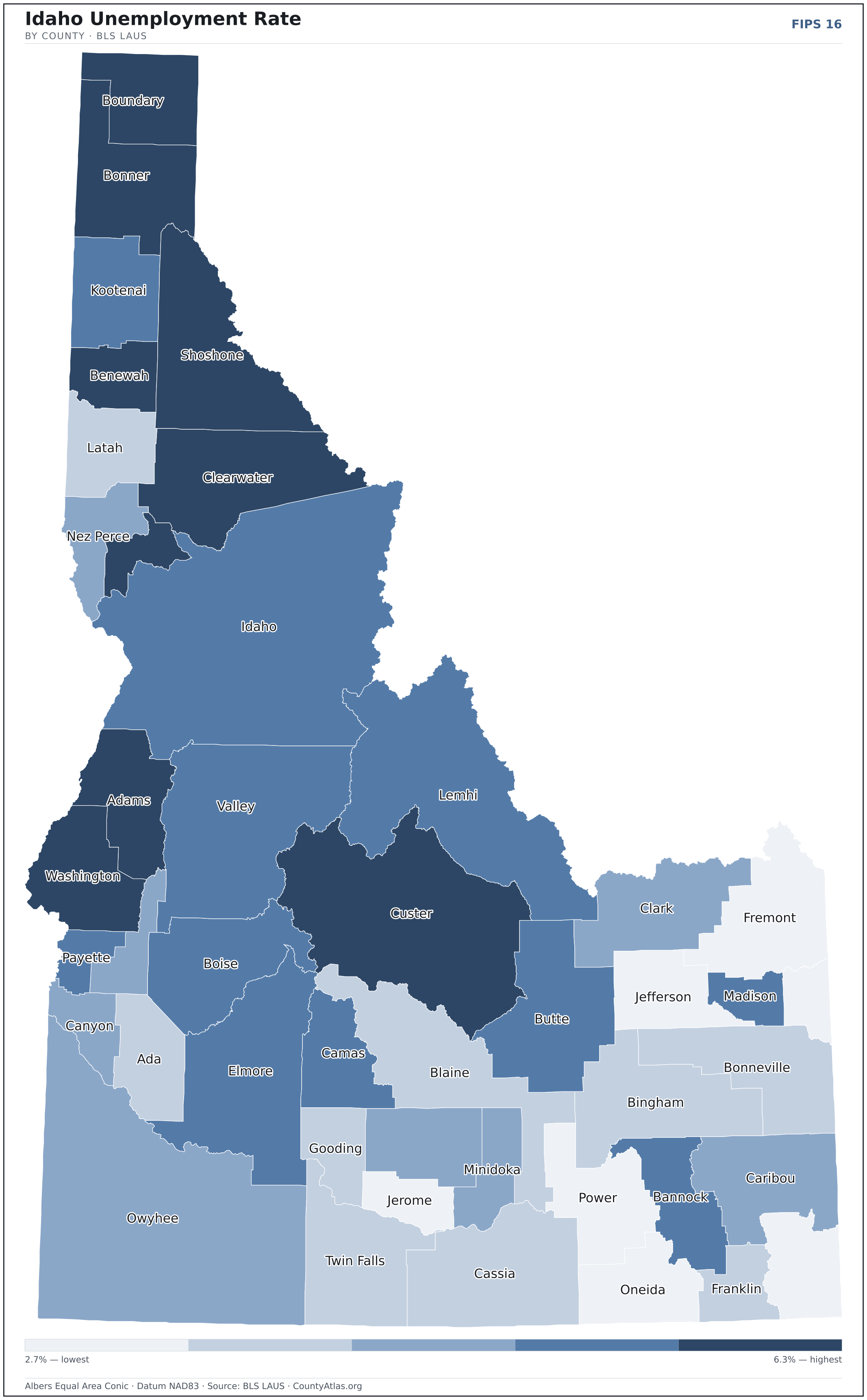
Cities in Idaho
Idaho has 200 incorporated cities. The largest is Boise City in Ada County with 235,701 residents. Use the search on the map above to find any city and highlight the county it sits in.
| Boise City | Ada County | 235,701 |
| Meridian | Ada County | 124,865 |
| Nampa | Canyon County | 106,289 |
| Idaho Falls | Bonneville County | 66,672 |
| Caldwell | Canyon County | 63,465 |
| Pocatello | Bannock County | 57,152 |
| Coeur d'Alene | Kootenai County | 55,558 |
| Twin Falls | Twin Falls County | 53,219 |
| Post Falls | Kootenai County | 41,716 |
| Rexburg | Madison County | 39,589 |
| Lewiston | Nez Perce County | 34,471 |
| Eagle | Ada County | 31,490 |
| Kuna | Ada County | 25,960 |
| Moscow | Latah County | 25,868 |
| Ammon | Bonneville County | 18,496 |
| Mountain Home | Elmore County | 16,265 |
| Hayden | Kootenai County | 16,021 |
| Chubbuck | Bannock County | 15,900 |
| Star | Ada County | 13,231 |
| Jerome | Jerome County | 12,689 |
| Blackfoot | Bingham County | 12,628 |
| Garden City | Ada County | 12,483 |
| Burley | Cassia County | 11,721 |
| Rathdrum | Kootenai County | 10,133 |
| Middleton | Canyon County | 10,101 |
| Hailey | Blaine County | 9,439 |
| Sandpoint | Bonner County | 9,244 |
| Payette | Payette County | 8,358 |
| Emmett | Gem County | 7,948 |
| Fruitland | Payette County | 6,405 |
| Rupert | Minidoka County | 6,157 |
| Weiser | Washington County | 5,803 |
| Preston | Franklin County | 5,800 |
| Rigby | Jefferson County | 5,251 |
| Shelley | Bingham County | 4,987 |
| Kimberly | Twin Falls County | 4,883 |
| American Falls | Power County | 4,636 |
| Buhl | Twin Falls County | 4,624 |
| McCall | Valley County | 3,847 |
| St. Anthony | Fremont County | 3,818 |
| Gooding | Gooding County | 3,731 |
| Heyburn | Minidoka County | 3,678 |
| Ketchum | Blaine County | 3,551 |
| Grangeville | Idaho County | 3,443 |
| Orofino | Clearwater County | 3,254 |
| Salmon | Lemhi County | 3,196 |
| Soda Springs | Caribou County | 3,150 |
| St. Maries | Benewah County | 3,032 |
| Victor | Teton County | 3,024 |
| Homedale | Owyhee County | 3,006 |
Showing the 50 most populous — and 150 more. Search the map above for any Idaho city or village.
A city can span more than one county; each is listed in its primary county — the one its center falls in.
Which Idaho county is the richest, largest, most crowded? The answers
- Idaho’s highest median household income is in Teton County ($94,895); the lowest is in Lewis County ($53,212). Census SAIPE 2023
- Idaho’s most populous county is Ada County (524,673); the least populous is Clark County (801) — a 655× spread. Census PEP 2023
- Idaho’s largest county by land area is Idaho County (8,478 sq mi); the smallest is Payette County (407 sq mi). Census TIGER
- Idaho’s highest population density is in Ada County (499/sq mi); the lowest is in Clark County (0/sq mi). Census PEP 2023 · TIGER
- Idaho’s highest poverty rate is in Madison County (20.6%); the lowest is in Teton County (6.6%). Census SAIPE 2023
- In Idaho, unemployment is highest in Adams County (6.3%) and lowest in Oneida County (2.7%), for May 2026. BLS LAUS
- Idaho’s highest median age is in Custer County (59.5); the lowest is in Madison County (21.4). Census ACS 2019–2023
- Idaho’s highest share of bachelor’s degrees is in Teton County (48.3% of adults); the lowest is in Shoshone County (11.5%). Census ACS 2019–2023
Every figure is a current official estimate from the source named — not a crowd-sourced or copied value. Suppressed estimates (coefficient of variation ≥ 0.30) are omitted, never guessed. See the full methodology.
Idaho counties: common questions
How many counties are in Idaho?
Idaho has 44 counties covering 82,645 sq mi and about 2.0M residents. Every one is on the map above and in the table below.
What is the largest county in Idaho?
It depends on the measure. By land area it’s Idaho County (8,478 sq mi); by population it’s Ada County (524,673 residents).
What county is Boise City in?
Boise City (population 235,701) is in Ada County. Use the search on the map to find any Idaho city’s county.
What is the richest county in Idaho?
By median household income, Teton County is the richest at $94,895; the poorest is Lewis County at $53,212 (Census SAIPE 2023).
What is the most populous county in Idaho?
Ada County, with 524,673 residents — about 26.7% of Idaho’s people, and 655× the least populous, Clark County (801).
Sources & vintages
- Population — PEP Vintage 2023 (July 1, 2023) — pep/charv
- Median household income & poverty — SAIPE 2023
- Unemployment — BLS LAUS May 2026 (preliminary)
- Geometry & boundaries — Census TIGERweb
- Cities & city population — Census TIGERweb Incorporated Places + ACS 5-year 2019–2023
Data current through .