CountyAtlas Mississippi
Mississippi County Map with Cities — All 82 Counties
All 82 of Mississippi's counties, mapped from official U.S. Census boundaries with population, income, and unemployment for every one. Colour the map by any measure, tap a county for its data, or download a print-ready copy.
Tap any county for its population, income, and more.
Mississippi at a glance
- Scale. Mississippi is divided into 82 counties across 46,925 sq mi of land — an average of 572 sq mi each. Census TIGER
- People. Its counties are home to 2,939,690 residents — an average of 35,850 each, or 63 per square mile statewide. Census PEP 2023
- Water. Another 1,511 sq mi is water — 3.1% of the state’s area, led by Harrison County. Census TIGER
Mississippi’s 82 counties, by the numbers
Every county’s population, median household income, unemployment, density, and land area — sortable by any column, so you can find yours or rank by what matters to you. A few patterns run through the data:
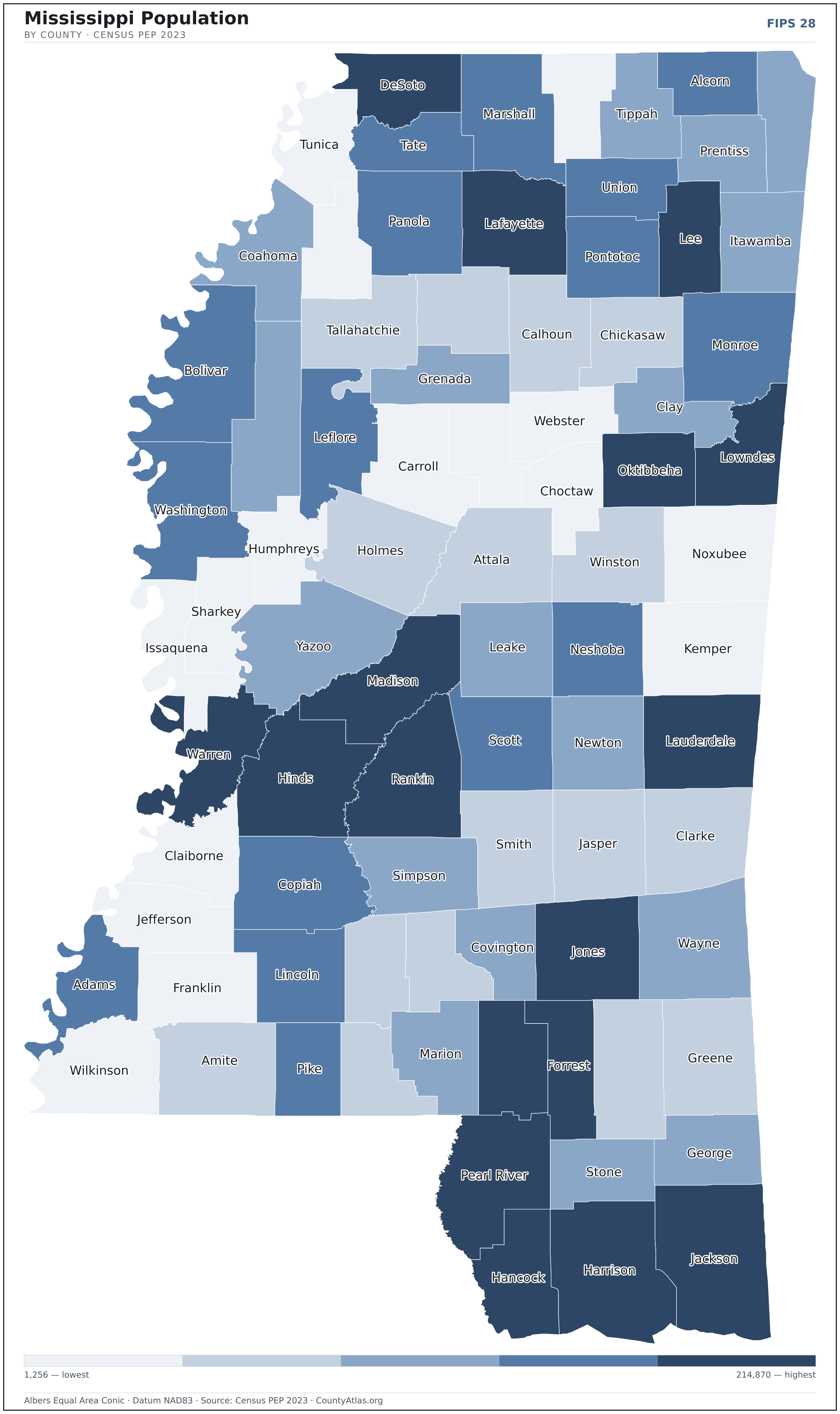
- Concentrated. Half of Mississippi’s 2,939,690 residents live in just 13 of 82 counties, and the five largest hold 31.5% of the total. Census PEP 2023
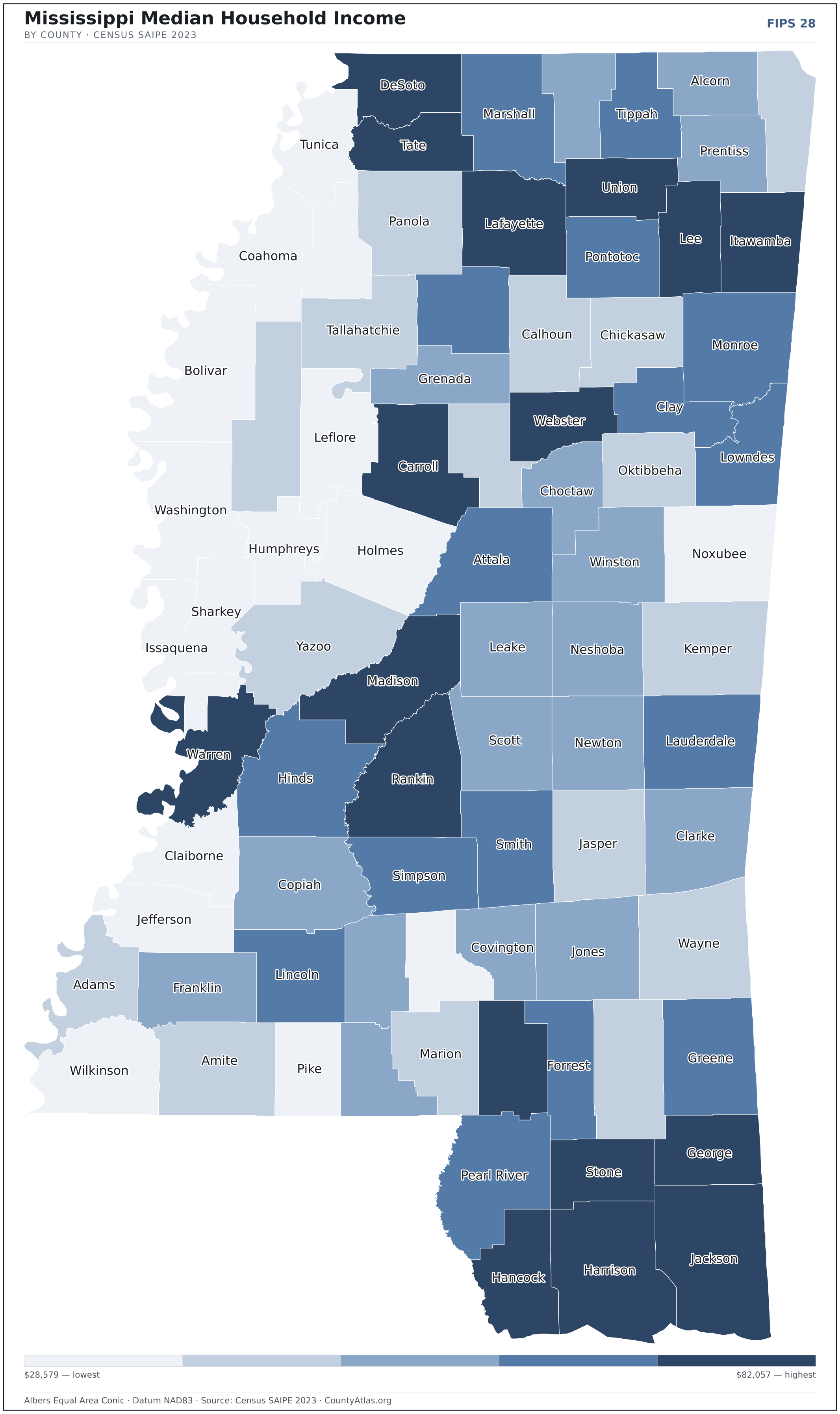
- Income tracks poverty. The gap from richest to poorest runs 2.9×, and the 10 highest-income counties average 12.8% in poverty against 33.8% for the 10 lowest. Census SAIPE 2023
- Mostly small. Half of Mississippi’s counties have fewer than 21,273 residents, and half report a median household income below $48,950 — a few metros lift the statewide totals well above both. Census PEP 2023 · SAIPE 2023
- Lopsided density. Only 22 of 82 counties are denser than Mississippi’s statewide average of 63 people per square mile — the rest are more rural. Census PEP 2023 · TIGER
| Adams County | 28,746 | $44,385 | 4.8% | 62/sq mi | 462 sq mi | Natchez |
| Alcorn County | 34,135 | $48,556 | 3.0% | 85/sq mi | 400 sq mi | Corinth |
| Amite County | 12,442 | $46,108 | 4.1% | 17/sq mi | 730 sq mi | Liberty |
| Attala County | 17,359 | $52,128 | 3.6% | 24/sq mi | 735 sq mi | Kosciusko |
| Benton County | 7,438 | $47,969 | 3.9% | 18/sq mi | 407 sq mi | Ashland |
| Bolivar County | 28,968 | $39,920 | 4.6% | 33/sq mi | 877 sq mi | Cleveland; Rosedale |
| Calhoun County | 12,685 | $46,966 | 3.1% | 22/sq mi | 587 sq mi | Pittsboro |
| Carroll County | 9,535 | $55,290 | 4.0% | 15/sq mi | 628 sq mi | Carrollton; Vaiden |
| Chickasaw County | 16,866 | $44,599 | 4.3% | 34/sq mi | 502 sq mi | Houston; Okolona |
| Choctaw County | 8,088 | $50,545 | 3.9% | 19/sq mi | 418 sq mi | Ackerman |
| Claiborne County | 8,617 | $28,579 | 7.4% | 18/sq mi | 487 sq mi | Port Gibson |
| Clarke County | 15,228 | $47,811 | 3.8% | 22/sq mi | 692 sq mi | Quitman |
| Clay County | 18,206 | $52,673 | 4.5% | 44/sq mi | 410 sq mi | West Point |
| Coahoma County | 20,077 | $35,552 | 7.1% | 36/sq mi | 553 sq mi | Clarksdale |
| Copiah County | 27,664 | $47,870 | 3.6% | 36/sq mi | 777 sq mi | Hazlehurst |
| Covington County | 18,059 | $48,382 | 3.4% | 44/sq mi | 414 sq mi | Collins |
| DeSoto County | 193,247 | $81,956 | 3.4% | 406/sq mi | 476 sq mi | Hernando |
| Forrest County | 78,208 | $51,328 | 3.3% | 168/sq mi | 466 sq mi | Hattiesburg |
| Franklin County | 7,610 | $48,075 | 4.2% | 13/sq mi | 564 sq mi | Meadville |
| George County | 25,619 | $63,349 | 4.0% | 54/sq mi | 479 sq mi | Lucedale |
| Greene County | 13,601 | $54,057 | 5.8% | 19/sq mi | 713 sq mi | Leakesville |
| Grenada County | 21,065 | $49,210 | 3.9% | 50/sq mi | 422 sq mi | Grenada |
| Hancock County | 46,159 | $61,126 | 2.8% | 97/sq mi | 474 sq mi | Bay St. Louis |
| Harrison County | 210,612 | $56,692 | 3.2% | 367/sq mi | 574 sq mi | Biloxi; Gulfport |
| Hinds County | 214,870 | $50,965 | 3.8% | 247/sq mi | 870 sq mi | Jackson; Raymond |
| Holmes County | 15,777 | $30,542 | 6.5% | 21/sq mi | 757 sq mi | Lexington |
| Humphreys County | 7,216 | $31,538 | 5.9% | 17/sq mi | 419 sq mi | Belzoni |
| Issaquena County | 1,256 | $36,986 | 8.8% | 3/sq mi | 413 sq mi | Mayersville |
| Itawamba County | 24,093 | $56,977 | 3.3% | 45/sq mi | 533 sq mi | Fulton |
| Jackson County | 146,389 | $66,751 | 3.3% | 203/sq mi | 723 sq mi | Pascagoula |
| Jasper County | 16,013 | $46,577 | 4.0% | 24/sq mi | 676 sq mi | Bay Springs |
| Jefferson County | 6,941 | $37,617 | 8.5% | 13/sq mi | 520 sq mi | Fayette |
| Jefferson Davis County | 10,969 | $39,794 | 3.6% | 27/sq mi | 408 sq mi | Prentiss |
| Jones County | 66,250 | $50,310 | 2.6% | 95/sq mi | 695 sq mi | Ellisville; Laurel |
| Kemper County | 8,584 | $42,461 | 4.8% | 11/sq mi | 766 sq mi | De Kalb |
| Lafayette County | 58,467 | $72,838 | 2.8% | 93/sq mi | 632 sq mi | Oxford |
| Lamar County | 66,217 | $63,079 | 3.0% | 133/sq mi | 497 sq mi | Purvis |
| Lauderdale County | 70,527 | $51,437 | 3.6% | 100/sq mi | 704 sq mi | Meridian |
| Lawrence County | 11,741 | $49,431 | 3.6% | 27/sq mi | 431 sq mi | Monticello |
| Leake County | 21,258 | $47,849 | 3.0% | 36/sq mi | 583 sq mi | Carthage |
| Lee County | 82,799 | $64,744 | 3.3% | 184/sq mi | 450 sq mi | Tupelo |
| Leflore County | 26,378 | $33,945 | 6.0% | 44/sq mi | 594 sq mi | Greenwood |
| Lincoln County | 34,702 | $52,040 | 3.6% | 59/sq mi | 586 sq mi | Brookhaven |
| Lowndes County | 57,283 | $53,883 | 3.9% | 113/sq mi | 506 sq mi | Columbus |
| Madison County | 112,511 | $82,057 | 2.8% | 158/sq mi | 714 sq mi | Canton |
| Marion County | 24,224 | $47,020 | 3.7% | 45/sq mi | 542 sq mi | Columbia |
| Marshall County | 34,123 | $52,334 | 4.2% | 48/sq mi | 706 sq mi | Holly Springs |
| Monroe County | 33,609 | $50,639 | 4.6% | 44/sq mi | 765 sq mi | Aberdeen |
| Montgomery County | 9,600 | $46,424 | 3.4% | 24/sq mi | 407 sq mi | Winona |
| Neshoba County | 28,789 | $49,446 | 3.1% | 50/sq mi | 570 sq mi | Philadelphia |
| Newton County | 21,019 | $49,338 | 3.6% | 36/sq mi | 578 sq mi | Decatur |
| Noxubee County | 9,914 | $37,567 | 4.8% | 14/sq mi | 695 sq mi | Macon |
| Oktibbeha County | 51,203 | $47,584 | 3.7% | 112/sq mi | 458 sq mi | Starkville |
| Panola County | 32,669 | $46,097 | 4.0% | 48/sq mi | 685 sq mi | Batesville; Sardis |
| Pearl River County | 57,978 | $54,266 | 3.3% | 71/sq mi | 812 sq mi | Poplarville |
| Perry County | 11,315 | $46,201 | 4.1% | 17/sq mi | 647 sq mi | New Augusta |
| Pike County | 39,394 | $41,815 | 4.4% | 96/sq mi | 409 sq mi | Magnolia |
| Pontotoc County | 31,535 | $51,490 | 3.5% | 63/sq mi | 498 sq mi | Pontotoc |
| Prentiss County | 25,135 | $50,292 | 3.3% | 61/sq mi | 415 sq mi | Booneville |
| Quitman County | 5,546 | $35,150 | 4.3% | 14/sq mi | 405 sq mi | Marks |
| Rankin County | 160,417 | $70,794 | 2.5% | 207/sq mi | 776 sq mi | Brandon |
| Scott County | 27,507 | $48,112 | 3.0% | 45/sq mi | 609 sq mi | Forest |
| Sharkey County | 3,336 | $37,098 | 5.7% | 8/sq mi | 432 sq mi | Rolling Fork |
| Simpson County | 25,715 | $53,352 | 3.2% | 44/sq mi | 589 sq mi | Mendenhall |
| Smith County | 14,099 | $53,814 | 3.4% | 22/sq mi | 636 sq mi | Raleigh |
| Stone County | 18,756 | $56,686 | 3.6% | 42/sq mi | 445 sq mi | Wiggins |
| Sunflower County | 24,468 | $43,980 | 4.8% | 35/sq mi | 698 sq mi | Indianola |
| Tallahatchie County | 11,837 | $42,319 | 3.1% | 18/sq mi | 646 sq mi | Charleston; Sumner |
| Tate County | 28,261 | $62,784 | 3.5% | 70/sq mi | 405 sq mi | Senatobia |
| Tippah County | 21,287 | $53,452 | 2.9% | 46/sq mi | 458 sq mi | Ripley |
| Tishomingo County | 18,507 | $47,264 | 3.2% | 44/sq mi | 424 sq mi | Iuka |
| Tunica County | 9,234 | $39,659 | 5.3% | 20/sq mi | 454 sq mi | Tunica |
| Union County | 28,284 | $55,304 | 2.9% | 68/sq mi | 416 sq mi | New Albany |
| Walthall County | 13,863 | $48,909 | 3.9% | 34/sq mi | 404 sq mi | Tylertown |
| Warren County | 42,298 | $55,783 | 4.3% | 72/sq mi | 589 sq mi | Vicksburg |
| Washington County | 41,946 | $39,081 | 5.2% | 58/sq mi | 724 sq mi | Greenville |
| Wayne County | 19,703 | $45,573 | 3.8% | 24/sq mi | 811 sq mi | Waynesboro |
| Webster County | 9,988 | $54,929 | 2.8% | 24/sq mi | 421 sq mi | Walthall |
| Wilkinson County | 8,058 | $36,240 | 4.7% | 12/sq mi | 678 sq mi | Woodville |
| Winston County | 17,416 | $48,990 | 3.6% | 29/sq mi | 607 sq mi | Louisville |
| Yalobusha County | 12,386 | $50,790 | 3.3% | 27/sq mi | 467 sq mi | Coffeeville; Water Valley |
| Yazoo County | 25,796 | $42,434 | 4.6% | 28/sq mi | 922 sq mi | Yazoo City |
All 82 counties, sortable by any column — click a heading. A suppressed estimate (coefficient of variation ≥ 0.30) shows a marker, never a guess. County seats are from Wikidata (CC0), each validated to a Census place inside its county; a county with no validated seat is left blank. See the methodology.
Download & print this Mississippi map
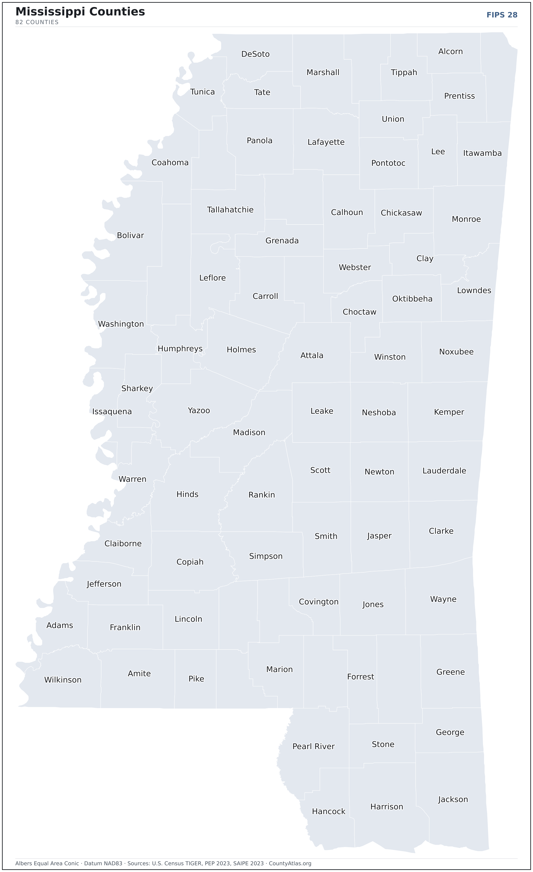
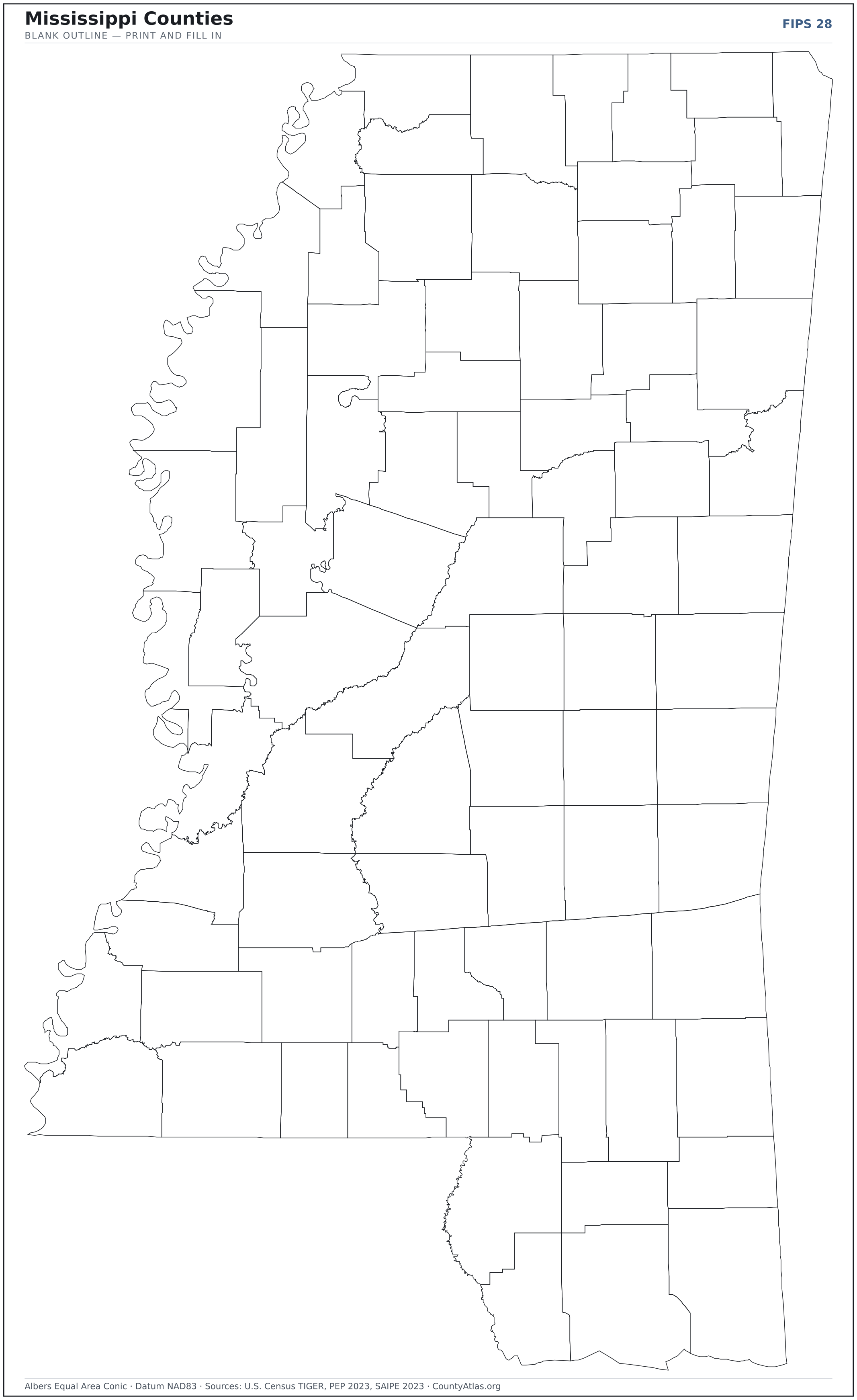
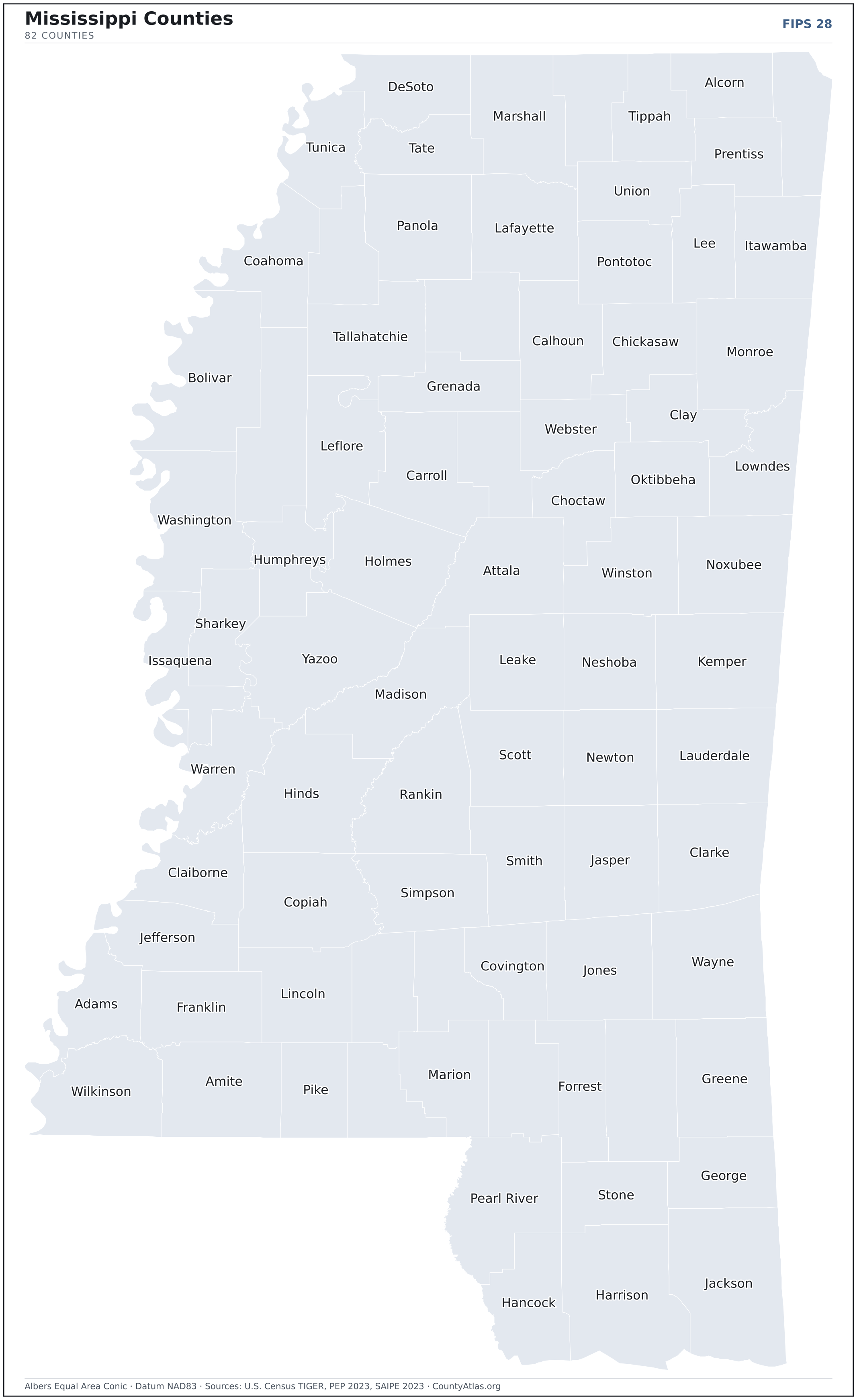
Mississippi maps, coloured by the data
Cities in Mississippi
Mississippi has 300 incorporated cities, towns, and villages. The largest is Jackson in Hinds County with 149,827 residents. Use the search on the map above to find any city and highlight the county it sits in.
| Jackson | Hinds County | 149,827 |
| Gulfport | Harrison County | 72,533 |
| Southaven | DeSoto County | 55,531 |
| Biloxi | Harrison County | 49,011 |
| Hattiesburg | Forrest County | 48,507 |
| Olive Branch | DeSoto County | 46,538 |
| Tupelo | Lee County | 37,825 |
| Meridian | Lauderdale County | 34,466 |
| Greenville | Washington County | 28,833 |
| Madison | Madison County | 27,775 |
| Pearl | Rankin County | 27,458 |
| Clinton | Hinds County | 27,418 |
| Horn Lake | DeSoto County | 26,622 |
| Oxford | Lafayette County | 26,086 |
| Starkville | Oktibbeha County | 25,611 |
| Brandon | Rankin County | 25,352 |
| Ridgeland | Madison County | 24,548 |
| Columbus | Lowndes County | 23,616 |
| Pascagoula | Jackson County | 21,812 |
| Vicksburg | Warren County | 20,944 |
| Gautier | Jackson County | 19,026 |
| Ocean Springs | Jackson County | 18,561 |
| Hernando | DeSoto County | 17,580 |
| Laurel | Jones County | 17,129 |
| Long Beach | Harrison County | 16,876 |
| Corinth | Alcorn County | 14,450 |
| Clarksdale | Coahoma County | 14,423 |
| Natchez | Adams County | 14,207 |
| Greenwood | Leflore County | 13,983 |
| D'Iberville | Harrison County | 13,033 |
| Byram | Hinds County | 12,847 |
| Grenada | Grenada County | 12,484 |
| McComb | Pike County | 12,202 |
| Moss Point | Jackson County | 12,066 |
| Picayune | Pearl River County | 11,839 |
| Brookhaven | Lincoln County | 11,656 |
| Petal | Forrest County | 11,195 |
| Canton | Madison County | 10,863 |
| Cleveland | Bolivar County | 10,855 |
| Flowood | Rankin County | 10,384 |
| Yazoo City | Yazoo County | 10,270 |
| Bay St. Louis | Hancock County | 9,971 |
| West Point | Clay County | 9,967 |
| Indianola | Sunflower County | 9,360 |
| Diamondhead | Hancock County | 9,338 |
| Booneville | Prentiss County | 9,060 |
| Senatobia | Tate County | 8,306 |
| New Albany | Union County | 7,661 |
| Batesville | Panola County | 7,432 |
| Richland | Rankin County | 7,250 |
Showing the 50 most populous — and 250 more. Search the map above for any Mississippi city or village.
A city can span more than one county; each is listed in its primary county — the one its center falls in.
Which Mississippi county is the richest, largest, most crowded? The answers
- Mississippi’s highest median household income is in Madison County ($82,057); the lowest is in Claiborne County ($28,579). Census SAIPE 2023
- Mississippi’s most populous county is Hinds County (214,870); the least populous is Issaquena County (1,256) — a 171× spread. Census PEP 2023
- Mississippi’s largest county by land area is Yazoo County (922 sq mi); the smallest is Alcorn County (400 sq mi). Census TIGER
- Mississippi’s highest population density is in DeSoto County (406/sq mi); the lowest is in Issaquena County (3/sq mi). Census PEP 2023 · TIGER
- Mississippi’s highest poverty rate is in Issaquena County (49.6%); the lowest is in DeSoto County (9.2%). Census SAIPE 2023
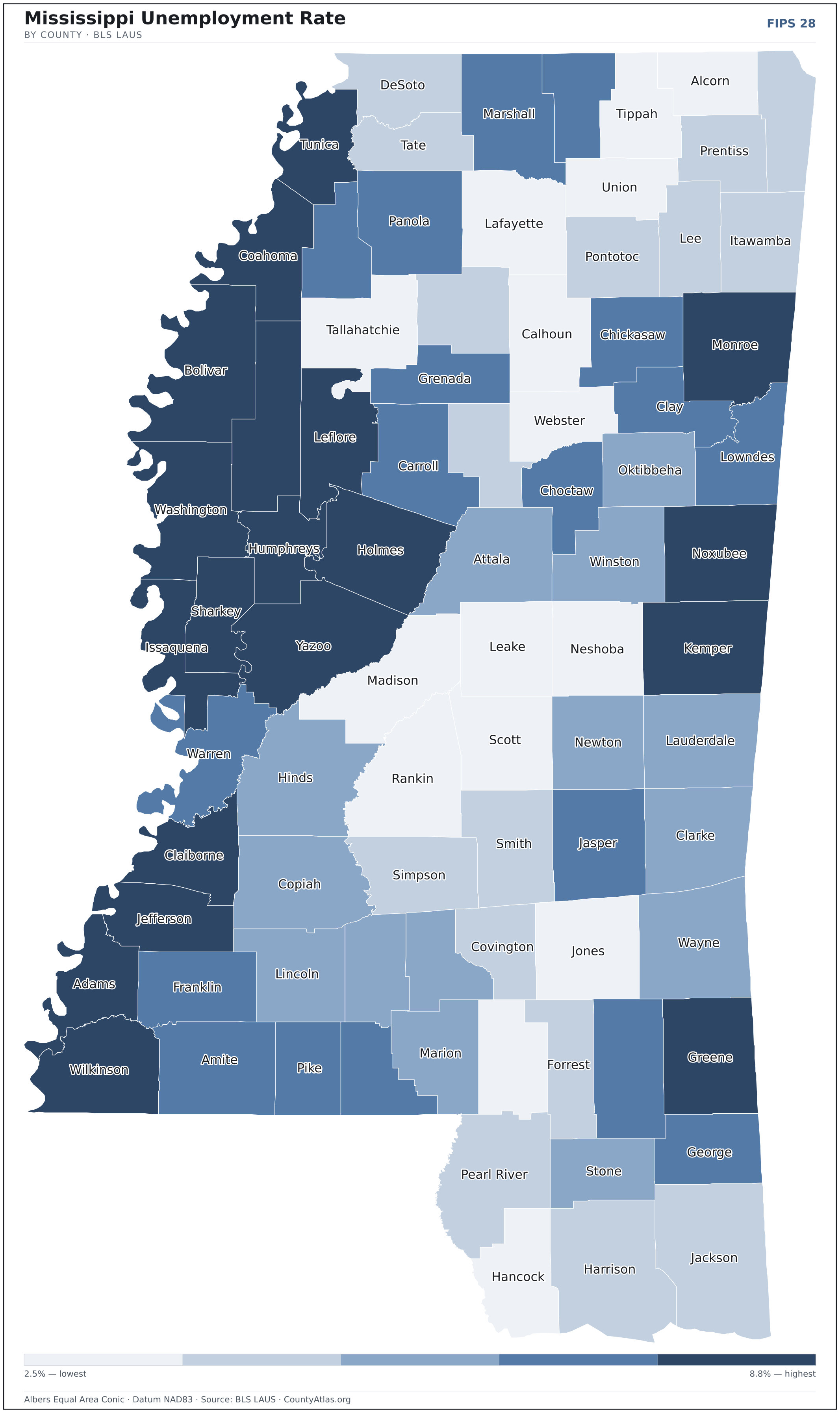
- In Mississippi, unemployment is highest in Issaquena County (8.8%) and lowest in Rankin County (2.5%), for May 2026. BLS LAUS
- Mississippi’s highest median age is in Issaquena County (49.5); the lowest is in Oktibbeha County (25.5). Census ACS 2019–2023
- Mississippi’s highest share of bachelor’s degrees is in Madison County (48.9% of adults); the lowest is in Amite County (8.0%). Census ACS 2019–2023
Every figure is a current official estimate from the source named — not a crowd-sourced or copied value. Suppressed estimates (coefficient of variation ≥ 0.30) are omitted, never guessed. See the full methodology.
Mississippi counties: common questions
How many counties are in Mississippi?
Mississippi has 82 counties covering 46,925 sq mi and about 2.9M residents. Every one is on the map above and in the table below.
What is the largest county in Mississippi?
It depends on the measure. By land area it’s Yazoo County (922 sq mi); by population it’s Hinds County (214,870 residents).
What county is Jackson in?
Jackson (population 149,827) is in Hinds County. Use the search on the map to find any Mississippi city’s county.
What is the richest county in Mississippi?
By median household income, Madison County is the richest at $82,057; the poorest is Claiborne County at $28,579 (Census SAIPE 2023).
What is the most populous county in Mississippi?
Hinds County, with 214,870 residents — about 7.3% of Mississippi’s people, and 171× the least populous, Issaquena County (1,256).
Sources & vintages
- Population — PEP Vintage 2023 (July 1, 2023) — pep/charv
- Median household income & poverty — SAIPE 2023
- Unemployment — BLS LAUS May 2026 (preliminary)
- Geometry & boundaries — Census TIGERweb
- Cities & city population — Census TIGERweb Incorporated Places + ACS 5-year 2019–2023
Data current through .