CountyAtlas North Dakota
North Dakota County Map with Cities — All 53 Counties
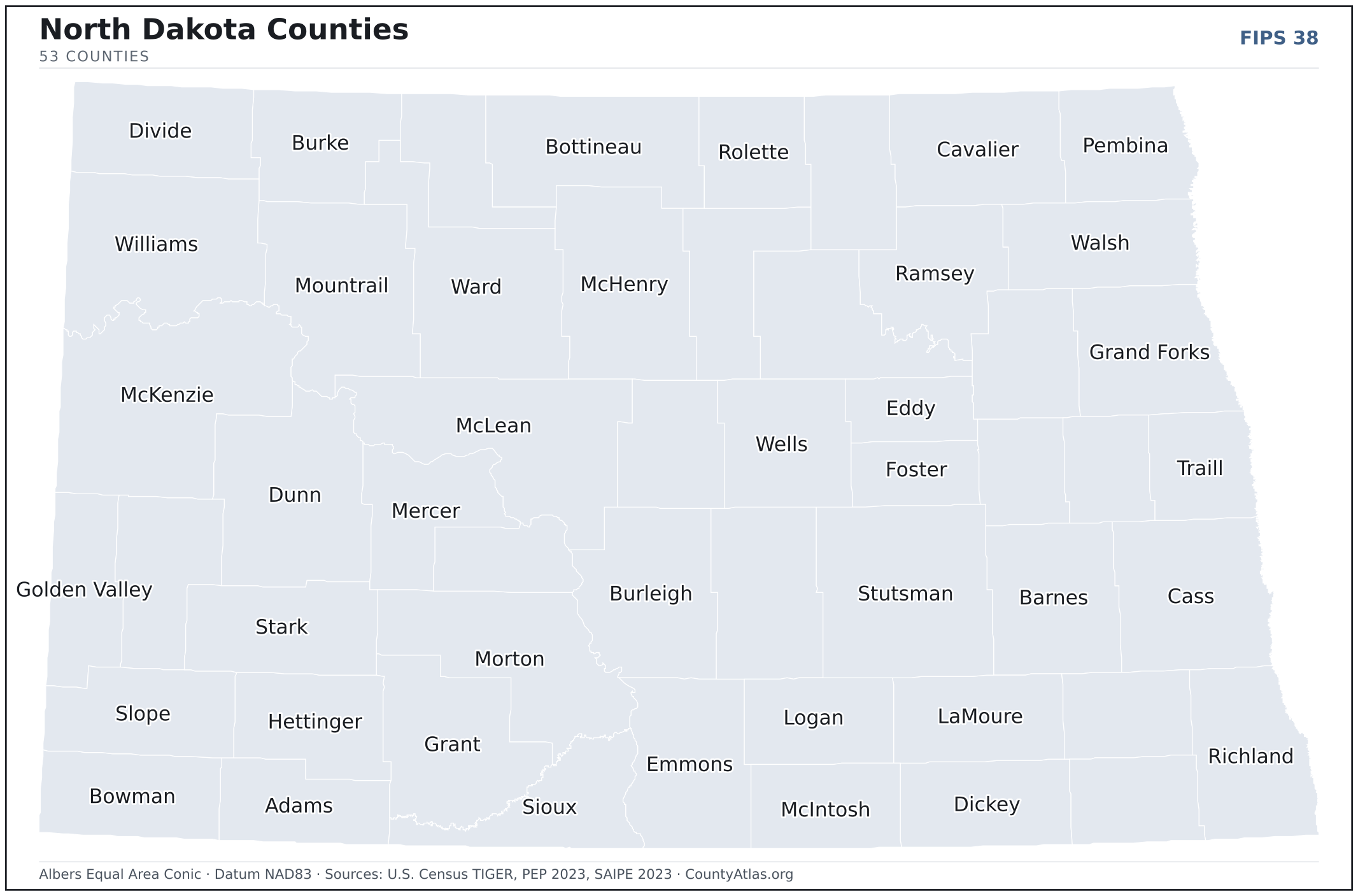
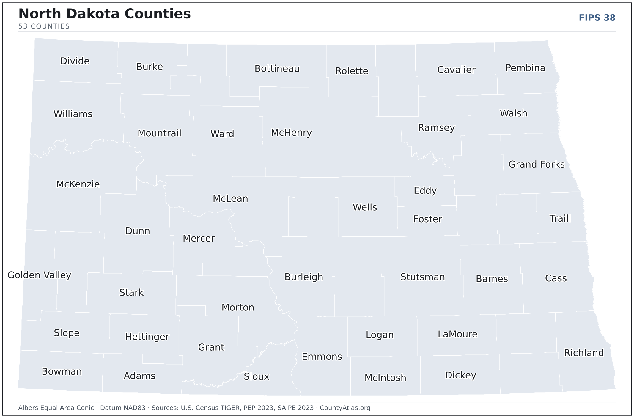
All 53 of North Dakota's counties, mapped from official U.S. Census boundaries with population, income, and unemployment for every one. Colour the map by any measure, tap a county for its data, or download a print-ready copy.
Tap any county for its population, income, and more.
North Dakota at a glance
- Scale. North Dakota is divided into 53 counties across 68,994 sq mi of land — an average of 1,302 sq mi each. Census TIGER
- People. Its counties are home to 783,926 residents — an average of 14,791 each, or 11 per square mile statewide. Census PEP 2023
- Water. Another 1,705 sq mi is water — 2.4% of the state’s area, led by McLean County. Census TIGER
North Dakota’s 53 counties, by the numbers
Every county’s population, median household income, unemployment, density, and land area — sortable by any column, so you can find yours or rank by what matters to you. A few patterns run through the data:
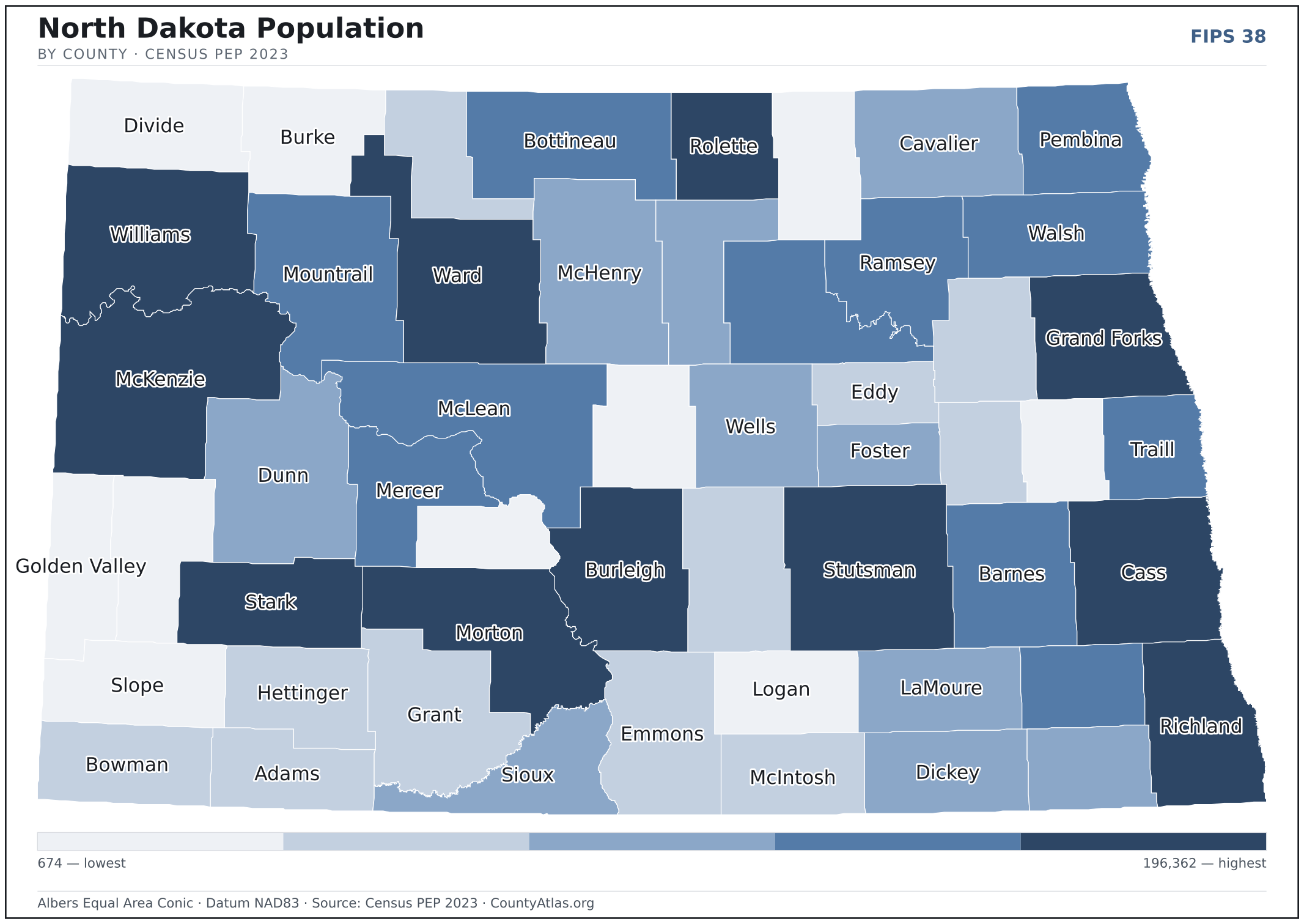
- Concentrated. Half of North Dakota’s 783,926 residents live in just 4 of 53 counties, and the five largest hold 60.8% of the total. Census PEP 2023
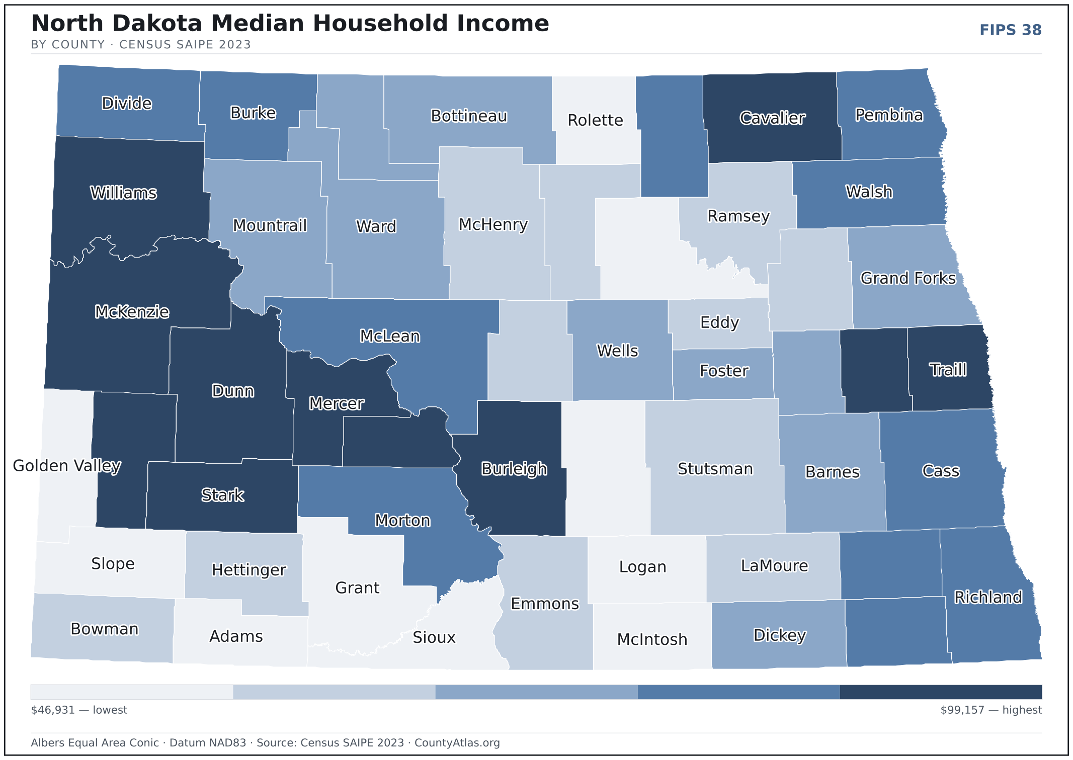
- Income tracks poverty. The gap from richest to poorest runs 2.1×, and the 10 highest-income counties average 9.0% in poverty against 17.7% for the 10 lowest. Census SAIPE 2023
- Mostly small. Half of North Dakota’s counties have fewer than 3,902 residents, and half report a median household income below $72,643 — a few metros lift the statewide totals well above both. Census PEP 2023 · SAIPE 2023
- Lopsided density. Only 9 of 53 counties are denser than North Dakota’s statewide average of 11 people per square mile — the rest are more rural. Census PEP 2023 · TIGER
| Adams County | 2,163 | $58,192 | 1.6% | 2/sq mi | 988 sq mi | Hettinger |
| Barnes County | 10,726 | $70,559 | 2.2% | 7/sq mi | 1,492 sq mi | Valley City |
| Benson County | 5,745 | $60,632 | 2.5% | 4/sq mi | 1,389 sq mi | Minnewaukan |
| Billings County | 1,034 | $82,565 | 1.3% | 1/sq mi | 1,148 sq mi | Medora |
| Bottineau County | 6,349 | $74,272 | 2.0% | 4/sq mi | 1,669 sq mi | Bottineau |
| Bowman County | 2,867 | $68,434 | 1.6% | 2/sq mi | 1,162 sq mi | Bowman |
| Burke County | 2,134 | $79,188 | 1.8% | 2/sq mi | 1,104 sq mi | Bowbells |
| Burleigh County | 100,012 | $86,521 | 1.7% | 61/sq mi | 1,633 sq mi | Bismarck |
| Cass County | 196,362 | $75,477 | 1.8% | 111/sq mi | 1,765 sq mi | Fargo |
| Cavalier County | 3,596 | $80,749 | 2.4% | 2/sq mi | 1,489 sq mi | Langdon |
| Dickey County | 4,900 | $72,643 | 1.1% | 4/sq mi | 1,131 sq mi | Ellendale |
| Divide County | 2,135 | $75,310 | 1.7% | 2/sq mi | 1,261 sq mi | Crosby |
| Dunn County | 4,019 | $87,618 | 2.2% | 2/sq mi | 2,008 sq mi | Manning |
| Eddy County | 2,263 | $66,603 | 2.2% | 4/sq mi | 630 sq mi | New Rockford |
| Emmons County | 3,224 | $65,012 | 2.7% | 2/sq mi | 1,508 sq mi | Linton |
| Foster County | 3,309 | $71,345 | 1.6% | 5/sq mi | 634 sq mi | Carrington |
| Golden Valley County | 1,743 | $59,464 | 1.4% | 2/sq mi | 1,001 sq mi | Beach |
| Grand Forks County | 72,708 | $72,369 | 1.6% | 51/sq mi | 1,436 sq mi | Grand Forks |
| Grant County | 2,215 | $51,827 | 1.8% | 1/sq mi | 1,659 sq mi | Carson |
| Griggs County | 2,248 | $71,071 | 1.7% | 3/sq mi | 709 sq mi | Cooperstown |
| Hettinger County | 2,415 | $64,506 | 2.0% | 2/sq mi | 1,132 sq mi | Mott |
| Kidder County | 2,342 | $60,473 | 2.7% | 2/sq mi | 1,351 sq mi | Steele |
| LaMoure County | 4,096 | $69,797 | 1.8% | 4/sq mi | 1,146 sq mi | LaMoure |
| Logan County | 1,869 | $61,043 | 2.1% | 2/sq mi | 993 sq mi | Napoleon |
| McHenry County | 5,131 | $68,973 | 2.9% | 3/sq mi | 1,874 sq mi | Towner |
| McIntosh County | 2,488 | $60,218 | 1.7% | 3/sq mi | 975 sq mi | Ashley |
| McKenzie County | 14,252 | $99,157 | 2.0% | 5/sq mi | 2,760 sq mi | Watford City |
| McLean County | 9,832 | $78,277 | 1.8% | 5/sq mi | 2,110 sq mi | Washburn |
| Mercer County | 8,309 | $85,274 | 2.2% | 8/sq mi | 1,043 sq mi | Stanton |
| Morton County | 33,895 | $80,159 | 1.8% | 18/sq mi | 1,926 sq mi | Mandan |
| Mountrail County | 9,383 | $73,541 | 2.3% | 5/sq mi | 1,825 sq mi | Stanley |
| Nelson County | 2,991 | $69,274 | 1.5% | 3/sq mi | 982 sq mi | Lakota |
| Oliver County | 1,879 | $81,382 | 2.4% | 3/sq mi | 722 sq mi | Center |
| Pembina County | 6,661 | $75,603 | 2.7% | 6/sq mi | 1,119 sq mi | Cavalier |
| Pierce County | 3,902 | $61,222 | 1.8% | 4/sq mi | 1,018 sq mi | Rugby |
| Ramsey County | 11,463 | $70,084 | 1.7% | 10/sq mi | 1,185 sq mi | Devils Lake |
| Ransom County | 5,603 | $78,270 | 1.9% | 6/sq mi | 862 sq mi | Lisbon |
| Renville County | 2,279 | $74,336 | 1.9% | 3/sq mi | 877 sq mi | Mohall |
| Richland County | 16,558 | $76,371 | 2.0% | 12/sq mi | 1,436 sq mi | Wahpeton |
| Rolette County | 11,728 | $56,952 | 3.3% | 13/sq mi | 903 sq mi | Rolla |
| Sargent County | 3,776 | $79,053 | 1.8% | 4/sq mi | 858 sq mi | Forman |
| Sheridan County | 1,266 | $62,251 | 2.8% | 1/sq mi | 972 sq mi | McClusky |
| Sioux County | 3,643 | $46,931 | 2.3% | 3/sq mi | 1,094 sq mi | Fort Yates |
| Slope County | 674 | $56,665 | 1.8% | 1/sq mi | 1,215 sq mi | Amidon |
| Stark County | 33,001 | $82,174 | 2.0% | 25/sq mi | 1,335 sq mi | Dickinson |
| Steele County | 1,782 | $87,300 | 2.8% | 3/sq mi | 712 sq mi | Finley |
| Stutsman County | 21,392 | $69,088 | 1.8% | 10/sq mi | 2,222 sq mi | Jamestown |
| Towner County | 2,030 | $76,241 | 2.1% | 2/sq mi | 1,025 sq mi | Cando |
| Traill County | 7,908 | $82,020 | 1.6% | 9/sq mi | 862 sq mi | Hillsboro |
| Walsh County | 10,305 | $80,235 | 2.2% | 8/sq mi | 1,282 sq mi | Grafton |
| Ward County | 68,332 | $71,754 | 1.9% | 34/sq mi | 2,013 sq mi | Minot |
| Wells County | 3,876 | $74,681 | 2.3% | 3/sq mi | 1,271 sq mi | Fessenden |
| Williams County | 39,113 | $92,537 | 2.3% | 19/sq mi | 2,078 sq mi | Williston |
All 53 counties, sortable by any column — click a heading. A suppressed estimate (coefficient of variation ≥ 0.30) shows a marker, never a guess. County seats are from Wikidata (CC0), each validated to a Census place inside its county; a county with no validated seat is left blank. See the methodology.
Download & print this North Dakota map
North Dakota maps, coloured by the data
Cities in North Dakota
North Dakota has 355 incorporated cities. The largest is Fargo in Cass County with 129,064 residents. Use the search on the map above to find any city and highlight the county it sits in.
| Fargo | Cass County | 129,064 |
| Bismarck | Burleigh County | 74,146 |
| Grand Forks | Grand Forks County | 58,882 |
| Minot | Ward County | 47,922 |
| West Fargo | Cass County | 39,325 |
| Williston | Williams County | 27,964 |
| Dickinson | Stark County | 25,216 |
| Mandan | Morton County | 24,293 |
| Jamestown | Stutsman County | 15,774 |
| Wahpeton | Richland County | 7,996 |
| Devils Lake | Ramsey County | 7,170 |
| Valley City | Barnes County | 6,554 |
| Watford City | McKenzie County | 6,016 |
| Lincoln | Burleigh County | 4,309 |
| Grafton | Walsh County | 4,128 |
| Horace | Cass County | 3,964 |
| Beulah | Mercer County | 3,058 |
| New Town | Mountrail County | 2,725 |
| Casselton | Cass County | 2,640 |
| Rugby | Pierce County | 2,555 |
| Hazen | Mercer County | 2,509 |
| Lisbon | Ransom County | 2,262 |
| Carrington | Foster County | 2,171 |
| Stanley | Mountrail County | 2,089 |
| Bottineau | Bottineau County | 2,063 |
| Mayville | Traill County | 2,050 |
| Oakes | Dickey County | 2,046 |
| Langdon | Cavalier County | 1,835 |
| Harvey | Wells County | 1,720 |
| Surrey | Ward County | 1,672 |
| Hillsboro | Traill County | 1,643 |
| Tioga | Williams County | 1,525 |
| Bowman | Bowman County | 1,523 |
| Park River | Walsh County | 1,483 |
| Garrison | McLean County | 1,456 |
| Washburn | McLean County | 1,434 |
| New Rockford | Eddy County | 1,325 |
| Cavalier | Pembina County | 1,304 |
| Larimore | Grand Forks County | 1,262 |
| Mapleton | Cass County | 1,243 |
| Cando | Towner County | 1,199 |
| Burlington | Ward County | 1,169 |
| Rolla | Rolette County | 1,164 |
| Hettinger | Adams County | 1,141 |
| Crosby | Divide County | 1,116 |
| Thompson | Grand Forks County | 1,092 |
| Kenmare | Ward County | 1,027 |
| Velva | McHenry County | 997 |
| Enderlin | Ransom County | 987 |
| Parshall | Mountrail County | 957 |
Showing the 50 most populous — and 305 more. Search the map above for any North Dakota city or village.
A city can span more than one county; each is listed in its primary county — the one its center falls in.
Which North Dakota county is the richest, largest, most crowded? The answers
- North Dakota’s highest median household income is in McKenzie County ($99,157); the lowest is in Sioux County ($46,931). Census SAIPE 2023
- North Dakota’s most populous county is Cass County (196,362); the least populous is Slope County (674) — a 291× spread. Census PEP 2023
- North Dakota’s largest county by land area is McKenzie County (2,760 sq mi); the smallest is Eddy County (630 sq mi). Census TIGER
- North Dakota’s highest population density is in Cass County (111/sq mi); the lowest is in Slope County (1/sq mi). Census PEP 2023 · TIGER
- North Dakota’s highest poverty rate is in Sioux County (34.9%); the lowest is in Ward County (7.4%). Census SAIPE 2023
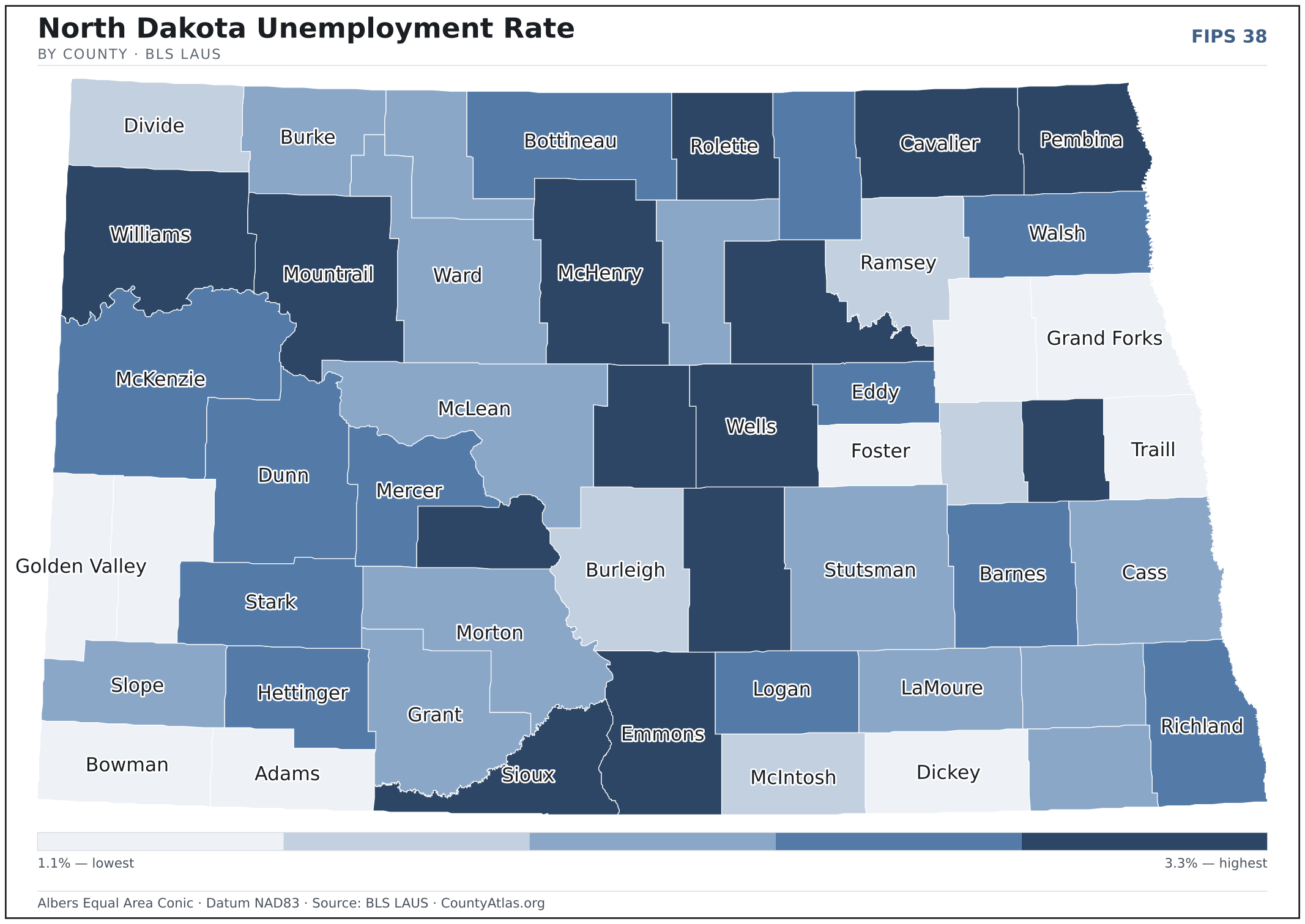
- In North Dakota, unemployment is highest in Rolette County (3.3%) and lowest in Dickey County (1.1%), for May 2026. BLS LAUS
- North Dakota’s highest median age is in Slope County (54.2); the lowest is in Sioux County (28.7). Census ACS 2019–2023
- North Dakota’s highest share of bachelor’s degrees is in Cass County (43.3% of adults); the lowest is in Sioux County (11.2%). Census ACS 2019–2023
Every figure is a current official estimate from the source named — not a crowd-sourced or copied value. Suppressed estimates (coefficient of variation ≥ 0.30) are omitted, never guessed. See the full methodology.
North Dakota counties: common questions
How many counties are in North Dakota?
North Dakota has 53 counties covering 68,994 sq mi and about 784K residents. Every one is on the map above and in the table below.
What is the largest county in North Dakota?
It depends on the measure. By land area it’s McKenzie County (2,760 sq mi); by population it’s Cass County (196,362 residents).
What county is Fargo in?
Fargo (population 129,064) is in Cass County. Use the search on the map to find any North Dakota city’s county.
What is the richest county in North Dakota?
By median household income, McKenzie County is the richest at $99,157; the poorest is Sioux County at $46,931 (Census SAIPE 2023).
What is the most populous county in North Dakota?
Cass County, with 196,362 residents — about 25.0% of North Dakota’s people, and 291× the least populous, Slope County (674).
Sources & vintages
- Population — PEP Vintage 2023 (July 1, 2023) — pep/charv
- Median household income & poverty — SAIPE 2023
- Unemployment — BLS LAUS May 2026 (preliminary)
- Geometry & boundaries — Census TIGERweb
- Cities & city population — Census TIGERweb Incorporated Places + ACS 5-year 2019–2023
Data current through .