Connecticut Town Map
Every Connecticut town on one map, with its county, its planning region, its population and its land area. Find a town by name or by your location, then read the list for any county.
Connecticut has 169 towns in 8 counties, and every part of the state’s land lies in one of the towns. The counties have had no government since 1960, and since 2022 the Census Bureau groups the towns in 9 planning regions instead. The largest town is Bridgeport, with 152,273 people in 2025; the smallest, Union, has 804.
- 169towns, covering all of the state’s land
- 8counties, without a government since 1960
- 9planning regions, the Census Bureau’s counties since 2022
- 804people in Union in 2025, the fewest
Map of Connecticut towns and counties
Town names fill in as you zoom; dark purple lines are the 8 counties. Press Planning regions to see the 9 areas the Census Bureau uses instead. Click or tap a town for its county, planning region, population and land area, type a name to find it, or press Find my town. Zoom in past the county view and the map draws the Census Bureau’s exact town lines.
Click or tap a town for its county, planning region, population and area, or find it by name.
Printable Connecticut town map
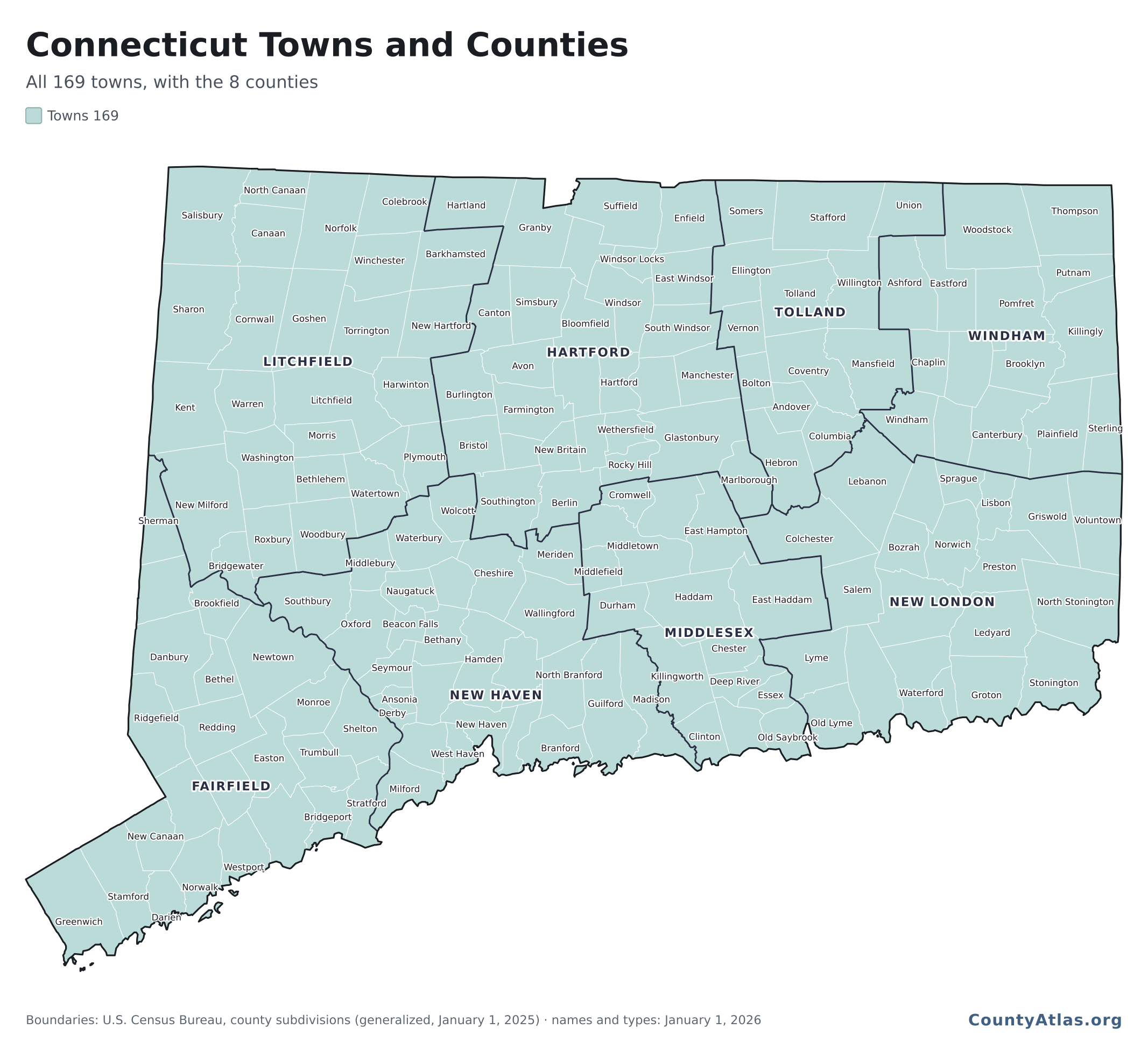
All 169 towns in one image, 2,133 × 1,939 pixels, with town and county lines and as many town names as fit without overlapping.
You may use this map for any purpose, commercial ones included, as long as the CountyAtlas.org credit printed on it stays with it, or a credit to CountyAtlas with a link sits next to the map where you use it.
Map of Connecticut cities
Connecticut’s big cities are towns in the Census Bureau’s list: Bridgeport, Stamford, New Haven, Hartford and Waterbury each have more than 100,000 people. These are the 20 most populous towns in the Census Bureau’s estimate for July 1, 2025; together they hold 44% of the state’s 3,688,496 residents.
| # | Town | County | People |
|---|---|---|---|
| 1 | Bridgeport | Fairfield | 152,273 |
| 2 | Stamford | Fairfield | 139,535 |
| 3 | New Haven | New Haven | 138,774 |
| 4 | Hartford | Hartford | 121,981 |
| 5 | Waterbury | New Haven | 115,771 |
| 6 | Norwalk | Fairfield | 94,508 |
| 7 | Danbury | Fairfield | 89,033 |
| 8 | New Britain | Hartford | 76,286 |
| 9 | Fairfield | Fairfield | 66,262 |
| 10 | Greenwich | Fairfield | 64,801 |
| 11 | West Hartford | Hartford | 64,242 |
| 12 | Bristol | Hartford | 62,341 |
| 13 | Hamden | New Haven | 61,824 |
| 14 | Meriden | New Haven | 60,810 |
| 15 | Manchester | Hartford | 59,773 |
| 16 | West Haven | New Haven | 55,351 |
| 17 | Stratford | Fairfield | 53,908 |
| 18 | Milford | New Haven | 53,606 |
| 19 | East Hartford | Hartford | 50,968 |
| 20 | Middletown | Middlesex | 48,439 |
Connecticut counties and planning regions
Connecticut abolished county government in 1960, but its 8 counties stayed on maps and in Census data until the Census Bureau adopted the state’s 9 planning regions, the areas of its councils of governments, as county-equivalents in 2022 (Federal Register). The two don’t line up: only Middlesex County (Lower Connecticut River Valley) has all its towns in one planning region. The table shows where each county’s towns fall.
| County | Towns | Planning regions (towns) |
|---|---|---|
| Hartford County | 29 | Capitol 26, Northwest Hills 2, Naugatuck Valley 1 |
| New Haven County | 27 | South Central Connecticut 15, Naugatuck Valley 12 |
| Litchfield County | 26 | Northwest Hills 19, Naugatuck Valley 5, Western Connecticut 2 |
| Fairfield County | 23 | Western Connecticut 16, Greater Bridgeport 6, Naugatuck Valley 1 |
| New London County | 21 | Southeastern Connecticut 18, Lower Connecticut River Valley 2, Northeastern Connecticut 1 |
| Middlesex County | 15 | Lower Connecticut River Valley 15 |
| Windham County | 15 | Northeastern Connecticut 14, Southeastern Connecticut 1 |
| Tolland County | 13 | Capitol 12, Northeastern Connecticut 1 |
The planning regions by number of towns: Capitol (38), Northwest Hills (21), Naugatuck Valley (19), Southeastern Connecticut (19), Western Connecticut (18), Lower Connecticut River Valley (17), Northeastern Connecticut (16), South Central Connecticut (15) and Greater Bridgeport (6). The Connecticut county map gives each planning region’s population, income and other figures.
List of towns in Connecticut by county
All 169 towns, county by county, with each one’s planning region, 2025 population and land area. Hartford County has the most, 29; Tolland County the fewest, 13. The same list is a free download: connecticut-towns.csv.
Fairfield County: 23 towns
| Town | Planning region | Population | Land (sq mi) |
|---|---|---|---|
| Bethel | Western Connecticut | 21,682 | 17.0 |
| Bridgeport | Greater Bridgeport | 152,273 | 16.1 |
| Brookfield | Western Connecticut | 18,566 | 19.7 |
| Danbury | Western Connecticut | 89,033 | 42.0 |
| Darien | Western Connecticut | 22,583 | 12.7 |
| Easton | Greater Bridgeport | 7,838 | 27.4 |
| Fairfield | Greater Bridgeport | 66,262 | 29.9 |
| Greenwich | Western Connecticut | 64,801 | 47.7 |
| Monroe | Greater Bridgeport | 19,341 | 26.1 |
| New Canaan | Western Connecticut | 21,208 | 22.2 |
| New Fairfield | Western Connecticut | 13,674 | 20.4 |
| Newtown | Western Connecticut | 28,183 | 57.5 |
| Norwalk | Western Connecticut | 94,508 | 22.9 |
| Redding | Western Connecticut | 8,847 | 31.5 |
| Ridgefield | Western Connecticut | 25,373 | 34.5 |
| Shelton | Naugatuck Valley | 42,880 | 30.6 |
| Sherman | Western Connecticut | 3,618 | 21.9 |
| Stamford | Western Connecticut | 139,535 | 37.6 |
| Stratford | Greater Bridgeport | 53,908 | 17.5 |
| Trumbull | Greater Bridgeport | 38,075 | 23.2 |
| Weston | Western Connecticut | 10,517 | 19.8 |
| Westport | Western Connecticut | 28,301 | 20.0 |
| Wilton | Western Connecticut | 19,435 | 26.8 |
Hartford County: 29 towns
| Town | Planning region | Population | Land (sq mi) |
|---|---|---|---|
| Avon | Capitol | 19,096 | 23.2 |
| Berlin | Capitol | 20,698 | 26.3 |
| Bloomfield | Capitol | 22,267 | 26.1 |
| Bristol | Naugatuck Valley | 62,341 | 26.4 |
| Burlington | Northwest Hills | 9,874 | 29.7 |
| Canton | Capitol | 10,304 | 24.6 |
| East Granby | Capitol | 5,432 | 17.5 |
| East Hartford | Capitol | 50,968 | 18.0 |
| East Windsor | Capitol | 11,342 | 26.2 |
| Enfield | Capitol | 41,142 | 33.3 |
| Farmington | Capitol | 28,632 | 27.9 |
| Glastonbury | Capitol | 35,503 | 51.3 |
| Granby | Capitol | 11,963 | 40.7 |
| Hartford | Capitol | 121,981 | 17.4 |
| Hartland | Northwest Hills | 1,928 | 33.0 |
| Manchester | Capitol | 59,773 | 27.4 |
| Marlborough | Capitol | 6,213 | 23.4 |
| New Britain | Capitol | 76,286 | 13.4 |
| Newington | Capitol | 31,647 | 13.1 |
| Plainville | Capitol | 17,746 | 9.7 |
| Rocky Hill | Capitol | 21,575 | 13.5 |
| Simsbury | Capitol | 25,582 | 33.9 |
| South Windsor | Capitol | 27,036 | 28.0 |
| Southington | Capitol | 44,242 | 35.9 |
| Suffield | Capitol | 16,046 | 42.3 |
| West Hartford | Capitol | 64,242 | 21.8 |
| Wethersfield | Capitol | 27,291 | 12.3 |
| Windsor | Capitol | 29,879 | 29.5 |
| Windsor Locks | Capitol | 12,617 | 9.0 |
Litchfield County: 26 towns
| Town | Planning region | Population | Land (sq mi) |
|---|---|---|---|
| Barkhamsted | Northwest Hills | 3,726 | 36.3 |
| Bethlehem | Naugatuck Valley | 3,455 | 19.4 |
| Bridgewater | Western Connecticut | 1,677 | 16.4 |
| Canaan | Northwest Hills | 1,091 | 32.9 |
| Colebrook | Northwest Hills | 1,388 | 31.6 |
| Cornwall | Northwest Hills | 1,589 | 46.1 |
| Goshen | Northwest Hills | 3,298 | 43.6 |
| Harwinton | Northwest Hills | 5,751 | 30.8 |
| Kent | Northwest Hills | 3,101 | 48.6 |
| Litchfield | Northwest Hills | 8,381 | 56.1 |
| Morris | Northwest Hills | 2,300 | 17.4 |
| New Hartford | Northwest Hills | 6,748 | 37.0 |
| New Milford | Western Connecticut | 28,941 | 61.6 |
| Norfolk | Northwest Hills | 1,605 | 45.3 |
| North Canaan | Northwest Hills | 3,231 | 19.4 |
| Plymouth | Naugatuck Valley | 11,902 | 21.9 |
| Roxbury | Northwest Hills | 2,328 | 26.3 |
| Salisbury | Northwest Hills | 4,290 | 57.2 |
| Sharon | Northwest Hills | 2,783 | 58.8 |
| Thomaston | Naugatuck Valley | 7,572 | 12.0 |
| Torrington | Northwest Hills | 35,796 | 39.8 |
| Warren | Northwest Hills | 1,389 | 26.3 |
| Washington | Northwest Hills | 3,733 | 38.1 |
| Watertown | Naugatuck Valley | 22,526 | 29.0 |
| Winchester | Northwest Hills | 10,360 | 32.5 |
| Woodbury | Naugatuck Valley | 10,005 | 36.4 |
Middlesex County: 15 towns
| Town | Planning region | Population | Land (sq mi) |
|---|---|---|---|
| Chester | Lower Connecticut River Valley | 3,726 | 16.1 |
| Clinton | Lower Connecticut River Valley | 13,439 | 16.2 |
| Cromwell | Lower Connecticut River Valley | 14,350 | 12.5 |
| Deep River | Lower Connecticut River Valley | 4,468 | 13.5 |
| Durham | Lower Connecticut River Valley | 7,209 | 23.7 |
| East Haddam | Lower Connecticut River Valley | 9,043 | 54.3 |
| East Hampton | Lower Connecticut River Valley | 13,134 | 35.7 |
| Essex | Lower Connecticut River Valley | 6,819 | 10.4 |
| Haddam | Lower Connecticut River Valley | 8,947 | 43.9 |
| Killingworth | Lower Connecticut River Valley | 6,288 | 35.3 |
| Middlefield | Lower Connecticut River Valley | 4,276 | 12.6 |
| Middletown | Lower Connecticut River Valley | 48,439 | 41.0 |
| Old Saybrook | Lower Connecticut River Valley | 10,680 | 15.1 |
| Portland | Lower Connecticut River Valley | 9,449 | 23.4 |
| Westbrook | Lower Connecticut River Valley | 6,918 | 15.8 |
New Haven County: 27 towns
| Town | Planning region | Population | Land (sq mi) |
|---|---|---|---|
| Ansonia | Naugatuck Valley | 19,216 | 6.0 |
| Beacon Falls | Naugatuck Valley | 6,307 | 9.7 |
| Bethany | South Central Connecticut | 5,339 | 21.1 |
| Branford | South Central Connecticut | 28,724 | 21.8 |
| Cheshire | Naugatuck Valley | 30,983 | 32.8 |
| Derby | Naugatuck Valley | 12,925 | 5.1 |
| East Haven | South Central Connecticut | 27,925 | 12.3 |
| Guilford | South Central Connecticut | 22,322 | 47.1 |
| Hamden | South Central Connecticut | 61,824 | 32.7 |
| Madison | South Central Connecticut | 17,734 | 36.1 |
| Meriden | South Central Connecticut | 60,810 | 23.7 |
| Middlebury | Naugatuck Valley | 8,093 | 17.8 |
| Milford | South Central Connecticut | 53,606 | 22.2 |
| Naugatuck | Naugatuck Valley | 32,230 | 16.4 |
| New Haven | South Central Connecticut | 138,774 | 18.7 |
| North Branford | South Central Connecticut | 13,551 | 24.8 |
| North Haven | South Central Connecticut | 24,799 | 20.8 |
| Orange | South Central Connecticut | 14,416 | 17.2 |
| Oxford | Naugatuck Valley | 13,311 | 32.7 |
| Prospect | Naugatuck Valley | 9,638 | 14.2 |
| Seymour | Naugatuck Valley | 17,153 | 14.5 |
| Southbury | Naugatuck Valley | 20,468 | 39.0 |
| Wallingford | South Central Connecticut | 44,406 | 39.2 |
| Waterbury | Naugatuck Valley | 115,771 | 28.6 |
| West Haven | South Central Connecticut | 55,351 | 10.8 |
| Wolcott | Naugatuck Valley | 16,573 | 20.4 |
| Woodbridge | South Central Connecticut | 9,160 | 18.8 |
New London County: 21 towns
| Town | Planning region | Population | Land (sq mi) |
|---|---|---|---|
| Bozrah | Southeastern Connecticut | 2,417 | 20.0 |
| Colchester | Southeastern Connecticut | 15,825 | 48.9 |
| East Lyme | Southeastern Connecticut | 19,223 | 34.0 |
| Franklin | Southeastern Connecticut | 1,915 | 19.7 |
| Griswold | Southeastern Connecticut | 11,690 | 34.7 |
| Groton | Southeastern Connecticut | 39,138 | 31.1 |
| Lebanon | Southeastern Connecticut | 7,142 | 54.1 |
| Ledyard | Southeastern Connecticut | 15,601 | 38.2 |
| Lisbon | Southeastern Connecticut | 4,260 | 16.3 |
| Lyme | Lower Connecticut River Valley | 2,424 | 31.8 |
| Montville | Southeastern Connecticut | 18,001 | 41.8 |
| New London | Southeastern Connecticut | 28,003 | 5.6 |
| North Stonington | Southeastern Connecticut | 5,242 | 54.2 |
| Norwich | Southeastern Connecticut | 40,001 | 28.1 |
| Old Lyme | Lower Connecticut River Valley | 7,702 | 23.0 |
| Preston | Southeastern Connecticut | 4,873 | 30.8 |
| Salem | Southeastern Connecticut | 4,324 | 28.9 |
| Sprague | Southeastern Connecticut | 2,954 | 13.2 |
| Stonington | Southeastern Connecticut | 18,832 | 38.6 |
| Voluntown | Northeastern Connecticut | 2,653 | 39.0 |
| Waterford | Southeastern Connecticut | 20,435 | 32.9 |
Tolland County: 13 towns
| Town | Planning region | Population | Land (sq mi) |
|---|---|---|---|
| Andover | Capitol | 3,173 | 15.4 |
| Bolton | Capitol | 4,875 | 14.4 |
| Columbia | Capitol | 5,352 | 21.4 |
| Coventry | Capitol | 12,446 | 37.6 |
| Ellington | Capitol | 16,594 | 34.0 |
| Hebron | Capitol | 9,256 | 36.9 |
| Mansfield | Capitol | 29,062 | 44.6 |
| Somers | Capitol | 10,938 | 28.5 |
| Stafford | Capitol | 11,721 | 58.0 |
| Tolland | Capitol | 14,752 | 39.7 |
| Union | Northeastern Connecticut | 804 | 28.8 |
| Vernon | Capitol | 30,842 | 17.7 |
| Willington | Capitol | 5,601 | 33.3 |
Windham County: 15 towns
| Town | Planning region | Population | Land (sq mi) |
|---|---|---|---|
| Ashford | Northeastern Connecticut | 4,265 | 38.8 |
| Brooklyn | Northeastern Connecticut | 8,748 | 29.1 |
| Canterbury | Northeastern Connecticut | 5,251 | 39.9 |
| Chaplin | Northeastern Connecticut | 2,187 | 19.4 |
| Eastford | Northeastern Connecticut | 1,715 | 28.9 |
| Hampton | Northeastern Connecticut | 1,768 | 25.1 |
| Killingly | Northeastern Connecticut | 18,177 | 48.3 |
| Plainfield | Northeastern Connecticut | 15,381 | 42.4 |
| Pomfret | Northeastern Connecticut | 4,378 | 40.3 |
| Putnam | Northeastern Connecticut | 9,402 | 20.3 |
| Scotland | Northeastern Connecticut | 1,591 | 18.6 |
| Sterling | Northeastern Connecticut | 3,736 | 27.2 |
| Thompson | Northeastern Connecticut | 9,566 | 46.9 |
| Windham | Southeastern Connecticut | 24,139 | 26.8 |
| Woodstock | Northeastern Connecticut | 8,474 | 60.7 |
Population: the Census Bureau’s estimate for July 1, 2025; the CSV and each town’s card on the map also give the 2020 Census count. Land: square miles of land, water left out. County: the county the town lies in; planning region: its county-equivalent in Census Bureau data since 2022.
Largest and smallest towns in Connecticut
By population, Bridgeport in Fairfield County is the largest, with 152,273 people in the Census Bureau’s 2025 estimate. By land, New Milford in Litchfield County is the largest at 61.6 square miles. The smallest is Union in Tolland County, with 804 residents. The smallest by land is Derby in New Haven County, at 5.1 square miles. Of the 169, 5 have 100,000 people or more and 1 has fewer than 1,000; the median town has 12,925.
| # | Town | County | People |
|---|---|---|---|
| 1 | Union | Tolland | 804 |
| 2 | Canaan | Litchfield | 1,091 |
| 3 | Colebrook | Litchfield | 1,388 |
| 4 | Warren | Litchfield | 1,389 |
| 5 | Cornwall | Litchfield | 1,589 |
| 6 | Scotland | Windham | 1,591 |
| 7 | Norfolk | Litchfield | 1,605 |
| 8 | Bridgewater | Litchfield | 1,677 |
| 9 | Eastford | Windham | 1,715 |
| 10 | Hampton | Windham | 1,768 |
| # | Town | County | Sq mi |
|---|---|---|---|
| 1 | New Milford | Litchfield | 61.6 |
| 2 | Woodstock | Windham | 60.7 |
| 3 | Sharon | Litchfield | 58.8 |
| 4 | Stafford | Tolland | 58.0 |
| 5 | Newtown | Fairfield | 57.5 |
| 6 | Salisbury | Litchfield | 57.2 |
| 7 | Litchfield | Litchfield | 56.1 |
| 8 | East Haddam | Middlesex | 54.3 |
| 9 | North Stonington | New London | 54.2 |
| 10 | Lebanon | New London | 54.1 |
| # | Town | County | Sq mi |
|---|---|---|---|
| 1 | Derby | New Haven | 5.1 |
| 2 | New London | New London | 5.6 |
| 3 | Ansonia | New Haven | 6.0 |
| 4 | Windsor Locks | Hartford | 9.0 |
| 5 | Beacon Falls | New Haven | 9.7 |
| 6 | Plainville | Hartford | 9.7 |
| 7 | Essex | Middlesex | 10.4 |
| 8 | West Haven | New Haven | 10.8 |
| 9 | Thomaston | Litchfield | 12.0 |
| 10 | East Haven | New Haven | 12.3 |
Fastest-growing and shrinking towns since 2020
From April 2020 to July 1, 2025, 157 of the 169 towns grew, 12 shrank, while Connecticut went from 3,607,750 to 3,688,496 residents. Among towns of 1,000 people or more, Granby in Hartford County grew fastest, +9.8%, and Enfield in Hartford County lost the largest share, −2.3%.
| # | Town | County | Change |
|---|---|---|---|
| 1 | Granby | Hartford | +9.8% |
| 2 | Cheshire | New Haven | +9.1% |
| 3 | Fairfield | Fairfield | +7.7% |
| 4 | Farmington | Hartford | +7.2% |
| 5 | Middlebury | New Haven | +6.9% |
| 6 | Mansfield | Tolland | +6.9% |
| 7 | Somers | Tolland | +6.6% |
| 8 | Bethel | Fairfield | +6.4% |
| 9 | Brookfield | Fairfield | +6.0% |
| 10 | Haddam | Middlesex | +5.8% |
| # | Town | County | Change |
|---|---|---|---|
| 1 | Enfield | Hartford | −2.3% |
| 2 | Montville | New London | −2.1% |
| 3 | Windham | Windham | −1.2% |
| 4 | Wallingford | New Haven | −0.6% |
| 5 | Chester | Middlesex | −0.6% |
| 6 | Sprague | New London | −0.5% |
| 7 | West Haven | New Haven | −0.4% |
| 8 | Norwich | New London | −0.4% |
| 9 | East Hartford | Hartford | −0.2% |
| 10 | East Haven | New Haven | −0.1% |
Change: from the Census Bureau’s estimates base for April 1, 2020 to its estimate for July 1, 2025. The tables leave out towns under 1,000 people, where a handful of residents would swing the percentage.
Connecticut towns: common questions
How many towns are in Connecticut?
169, in 8 counties: from 29 in Hartford County to 13 in Tolland County. The Census Bureau lists every one as a town, the big cities included.
What are all the towns in Connecticut?
All 169 are in the list above, county by county, with each one’s planning region, population and land area, and in the free CSV. On the map, type a name to find any of them.
Does Connecticut have counties?
It has 8 on the map, but they have had no government since 1960. Since 2022 the Census Bureau publishes Connecticut’s county-level data by its 9 planning regions instead (Federal Register). The two don’t line up, so the map draws either set of lines, and each town’s card gives both its county and its planning region.
What are Connecticut’s planning regions?
There are 9, by number of towns: Capitol (38 towns), Northwest Hills (21), Naugatuck Valley (19), Southeastern Connecticut (19), Western Connecticut (18), Lower Connecticut River Valley (17), Northeastern Connecticut (16), South Central Connecticut (15) and Greater Bridgeport (6). Each is the area of a council of governments, and since 2022 the Census Bureau uses them in place of the counties.
What is the largest town in Connecticut?
By population, Bridgeport in Fairfield County, with 152,273 people in the Census Bureau’s 2025 estimate, ahead of Stamford (139,535). By land, New Milford, at 61.6 square miles.
What is the smallest town in Connecticut?
By population, Union in Tolland County: 804 residents in the Census Bureau’s 2025 estimate (785 in the 2020 Census). By land, Derby in New Haven County, at 5.1 square miles.
Does Connecticut have unincorporated areas?
No. Every part of the state’s land lies in one of the 169 towns. The only parts of the state outside them in the Census Bureau’s list are open water off the Greater Bridgeport, Lower Connecticut River Valley, South Central Connecticut, Southeastern Connecticut and Western Connecticut planning regions.
What town am I in?
Press Find my town on the map above: it asks the Census Bureau which town your location is in and shows it. For an address, or anywhere outside Connecticut, use the township lookup.
Sources & vintages
- Source: U.S. Census Bureau, TIGERweb county subdivision boundaries, current vintage — retrieved Nov 2026
- Source: U.S. Census Bureau (published by the CTData Collaborative), Vintage 2025 population estimates for Connecticut towns — retrieved Nov 2026
- Source: U.S. Census Bureau, 2020 Census population of county subdivisions — retrieved Nov 2026
- Source: U.S. Census Bureau, generalized county subdivision boundaries (1:500,000) — retrieved Nov 2026
- Source: U.S. Census Bureau (Federal Register), Federal Register notice 2022-12063, June 6, 2022 — retrieved Nov 2026
Towns and land areas are the Census Bureau’s county subdivisions as of January 1, 2026; in Connecticut every county subdivision is a town, and its Census code carries its planning region. The county each town lies in comes from its 2020 Census code, which carried the county. Populations are the Census Bureau’s estimates for July 1, 2025 (Vintage 2025), as CTData Collaborative publishes them for the state’s population estimates dashboard, beside the 2020 Census counts. The map’s shapes are the Census Bureau’s generalized boundaries as of January 1, 2025, and from zoom 10 its exact current lines. Related: what township am I in · county lines map · Connecticut county map · Massachusetts town map · Maine town map · New Jersey township map · methodology.