Massachusetts Town Map
Every Massachusetts city and town on one map, colored by type, with its county, its population and its land area. Find a town by name or by your location, then read the list for any county.
Massachusetts has 351 cities and towns in 14 counties: 58 cities and 293 towns in the Census Bureau’s list. Together they cover all of the state’s land, so Massachusetts has no unincorporated area. Towns hold 85% of that land and 46% of the people in 2025.
- 351cities and towns in 14 counties
- 60in Worcester County, the most
- 58cities in the Census list; the state counts 39
- 62people in Gosnold in 2025, the fewest
Map of Massachusetts cities and towns
Each city and town is filled by its type and named; dark purple lines are county lines. Click or tap a town for its county, population and land area, type a name to find it, or press Find my town. Zoom in past the county view and the map draws the Census Bureau’s exact lines.
- Cities (58)
- Towns (293)
Click or tap a town for its type, county, population and area, or find it by name.
Printable Massachusetts town map
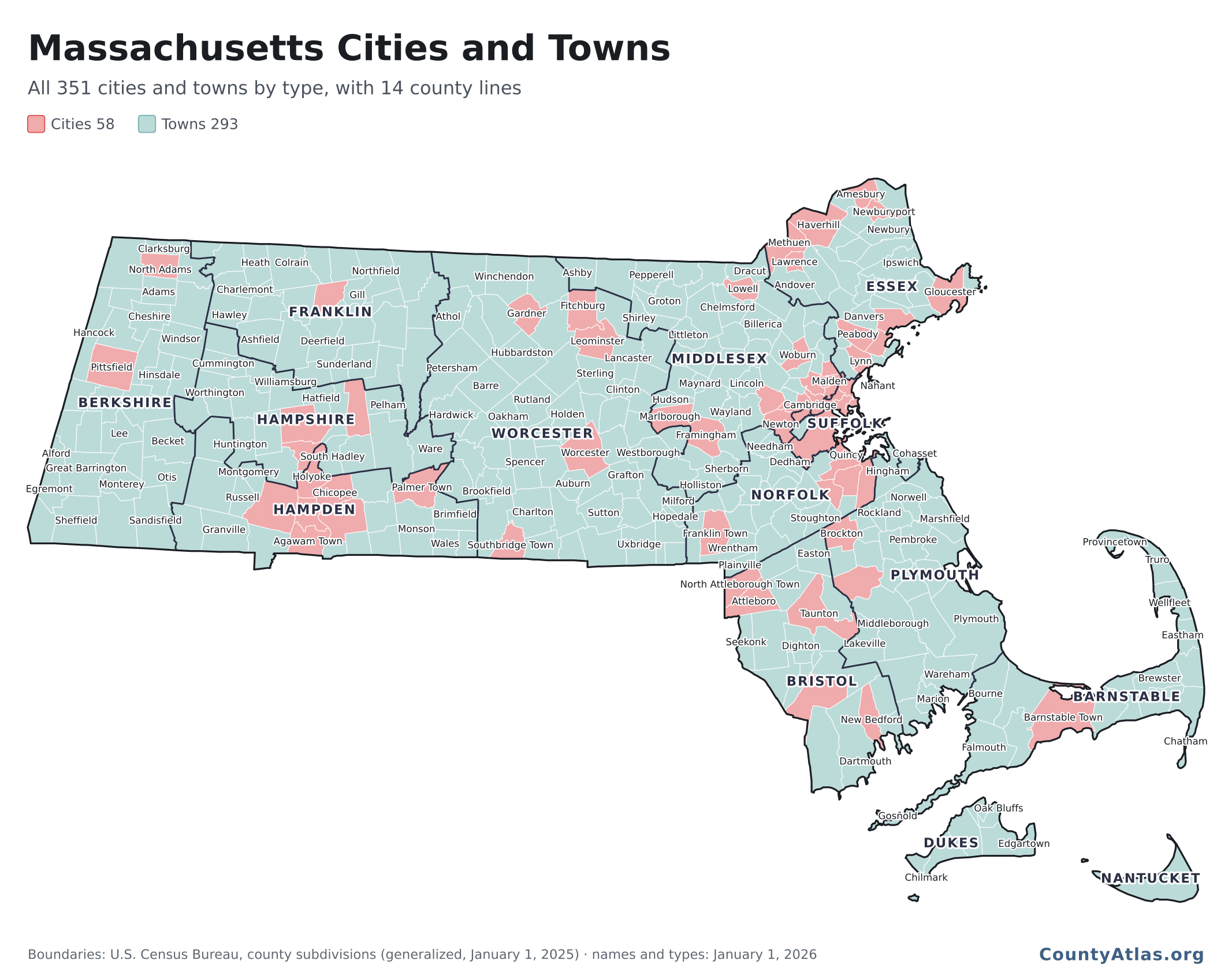
All 351 cities and towns in one image, 2,133 × 1,696 pixels: each filled by its type, with town and county lines and as many town names as fit without overlapping.
You may use this map for any purpose, commercial ones included, as long as the CountyAtlas.org credit printed on it stays with it, or a credit to CountyAtlas with a link sits next to the map where you use it.
How many cities are in Massachusetts?
39, 58 or 59, depending on who counts. The difference is the form of government, and a community with a city form doesn’t have to call itself a city. The Secretary of the Commonwealth counts 39 cities and 312 towns, and lists apart 13 places that have a city form of government but wish to be known as “The Town of” and 6 granted the title of city without wards. The Census Bureau lists 58 cities, the 39 plus those 13 and 6, and 293 towns; the 13 that keep the name town carry it in their Census names, such as Weymouth Town, Barnstable Town and Amherst Town. The Massachusetts Municipal Association counts 59 cities and 292 towns by form of government: its list of 14 city-form towns adds East Longmeadow, which the Census Bureau still lists as a town.
| Type | Count | Land | People |
|---|---|---|---|
| TownsMost populous: Plymouth (67,846) | 293 | 84.9% | 46.0% |
| CitiesMost populous: Boston (672,973) | 58 | 15.1% | 54.0% |
Types as the Census Bureau lists them. Land and people are each type’s share of the state’s land area and of its 7,154,084 residents in the Census Bureau’s estimate for July 1, 2025. The median city had 44,078 people in 2025 on 20.1 square miles, the median town 8,377 on 20.7.
Map of Massachusetts cities: all 58, largest first
The cities are the red shapes on the map. Boston is the largest, with 672,973 people in 2025; the smallest, Palmer Town and North Adams, are 1 resident apart, at 12,367 and 12,368. A municipality needs at least 12,000 people to adopt a city form of government (MMA).
| # | City | County | People |
|---|---|---|---|
| 1 | Boston | Suffolk | 672,973 |
| 2 | Worcester | Worcester | 213,862 |
| 3 | Springfield | Hampden | 154,702 |
| 4 | Cambridge | Middlesex | 122,588 |
| 5 | Lowell | Middlesex | 119,971 |
| 6 | Brockton | Plymouth | 106,134 |
| 7 | Lynn | Essex | 104,236 |
| 8 | Quincy | Norfolk | 103,173 |
| 9 | New Bedford | Bristol | 101,834 |
| 10 | Fall River | Bristol | 95,298 |
| 11 | Newton | Middlesex | 90,741 |
| 12 | Lawrence | Essex | 89,320 |
| 13 | Somerville | Middlesex | 84,211 |
| 14 | Framingham | Middlesex | 73,021 |
| 15 | Haverhill | Essex | 68,361 |
| 16 | Malden | Middlesex | 66,370 |
| 17 | Waltham | Middlesex | 65,037 |
| 18 | Taunton | Bristol | 62,522 |
| 19 | Revere | Suffolk | 60,141 |
| 20 | Medford | Middlesex | 59,834 |
| 21 | Weymouth Town | Norfolk | 59,759 |
| 22 | Peabody | Essex | 55,953 |
| 23 | Chicopee | Hampden | 55,310 |
| 24 | Methuen | Essex | 54,584 |
| 25 | Everett | Middlesex | 53,572 |
| 26 | Barnstable Town | Barnstable | 50,101 |
| 27 | Attleboro | Bristol | 47,447 |
| 28 | Salem | Essex | 45,381 |
| 29 | Leominster | Worcester | 44,194 |
| 30 | Woburn | Middlesex | 43,962 |
| 31 | Beverly | Essex | 43,363 |
| 32 | Pittsfield | Berkshire | 42,909 |
| 33 | Marlborough | Middlesex | 42,772 |
| 34 | Fitchburg | Worcester | 42,136 |
| 35 | Amherst Town | Hampshire | 40,920 |
| 36 | Westfield | Hampden | 40,546 |
| 37 | Chelsea | Suffolk | 40,130 |
| 38 | Braintree Town | Norfolk | 38,957 |
| 39 | Holyoke | Hampden | 38,023 |
| 40 | Watertown | Middlesex | 35,710 |
| 41 | Randolph Town | Norfolk | 34,948 |
| 42 | Franklin Town | Norfolk | 33,955 |
| 43 | North Attleborough Town | Bristol | 31,506 |
| 44 | Northampton | Hampshire | 31,047 |
| 45 | Gloucester | Essex | 30,627 |
| 46 | Melrose | Middlesex | 29,597 |
| 47 | Bridgewater Town | Plymouth | 29,309 |
| 48 | West Springfield Town | Hampden | 28,829 |
| 49 | Agawam Town | Hampden | 28,783 |
| 50 | Gardner | Worcester | 21,483 |
| 51 | Newburyport | Essex | 19,148 |
| 52 | Winthrop Town | Suffolk | 18,647 |
| 53 | Southbridge Town | Worcester | 18,105 |
| 54 | Greenfield | Franklin | 17,691 |
| 55 | Amesbury | Essex | 17,588 |
| 56 | Easthampton | Hampshire | 15,851 |
| 57 | North Adams | Berkshire | 12,368 |
| 58 | Palmer Town | Hampden | 12,367 |
List of towns in Massachusetts by county
All 351 cities and towns, county by county, with each one’s type, 2025 population and land area. Worcester County has the most, 60; Nantucket County has the fewest, 1, the town of Nantucket. The same list is a free download: massachusetts-cities-and-towns.csv.
Barnstable County: 15 cities and towns
| City or town | Type | Population | Land (sq mi) |
|---|---|---|---|
| Barnstable Town | city | 50,101 | 59.9 |
| Bourne | town | 20,772 | 40.7 |
| Brewster | town | 10,457 | 22.9 |
| Chatham | town | 6,752 | 16.2 |
| Dennis | town | 14,906 | 20.6 |
| Eastham | town | 5,844 | 14.0 |
| Falmouth | town | 33,361 | 44.1 |
| Harwich | town | 13,635 | 20.9 |
| Mashpee | town | 15,468 | 23.4 |
| Orleans | town | 6,524 | 14.2 |
| Provincetown | town | 3,729 | 9.7 |
| Sandwich | town | 20,575 | 42.9 |
| Truro | town | 2,483 | 21.0 |
| Wellfleet | town | 3,707 | 19.8 |
| Yarmouth | town | 25,225 | 24.2 |
Berkshire County: 32 cities and towns
| City or town | Type | Population | Land (sq mi) |
|---|---|---|---|
| Adams | town | 7,934 | 22.9 |
| Alford | town | 488 | 11.5 |
| Becket | town | 1,922 | 46.1 |
| Cheshire | town | 3,180 | 26.8 |
| Clarksburg | town | 1,625 | 12.7 |
| Dalton | town | 6,157 | 21.8 |
| Egremont | town | 1,369 | 18.7 |
| Florida | town | 700 | 24.4 |
| Great Barrington | town | 7,239 | 44.8 |
| Hancock | town | 748 | 35.7 |
| Hinsdale | town | 1,880 | 20.7 |
| Lanesborough | town | 2,999 | 28.9 |
| Lee | town | 5,673 | 26.1 |
| Lenox | town | 5,059 | 21.2 |
| Monterey | town | 1,093 | 26.4 |
| Mount Washington | town | 154 | 22.3 |
| New Ashford | town | 246 | 13.5 |
| New Marlborough | town | 1,500 | 46.9 |
| North Adams | city | 12,368 | 20.3 |
| Otis | town | 1,610 | 35.6 |
| Peru | town | 791 | 25.9 |
| Pittsfield | city | 42,909 | 40.5 |
| Richmond | town | 1,400 | 18.7 |
| Sandisfield | town | 983 | 51.8 |
| Savoy | town | 655 | 35.9 |
| Sheffield | town | 3,314 | 47.4 |
| Stockbridge | town | 1,982 | 22.7 |
| Tyringham | town | 422 | 18.6 |
| Washington | town | 502 | 38.0 |
| West Stockbridge | town | 1,319 | 18.5 |
| Williamstown | town | 9,186 | 46.7 |
| Windsor | town | 817 | 35.0 |
Bristol County: 20 cities and towns
| City or town | Type | Population | Land (sq mi) |
|---|---|---|---|
| Acushnet | town | 10,800 | 18.4 |
| Attleboro | city | 47,447 | 26.8 |
| Berkley | town | 6,950 | 16.5 |
| Dartmouth | town | 34,367 | 60.9 |
| Dighton | town | 8,348 | 22.0 |
| Easton | town | 25,795 | 28.8 |
| Fairhaven | town | 16,110 | 12.4 |
| Fall River | city | 95,298 | 33.1 |
| Freetown | town | 9,443 | 34.5 |
| Mansfield | town | 24,236 | 20.1 |
| New Bedford | city | 101,834 | 20.0 |
| North Attleborough Town | city | 31,506 | 18.9 |
| Norton | town | 19,559 | 27.8 |
| Raynham | town | 16,579 | 20.5 |
| Rehoboth | town | 13,567 | 46.9 |
| Seekonk | town | 16,046 | 18.4 |
| Somerset | town | 18,681 | 7.9 |
| Swansea | town | 17,701 | 22.7 |
| Taunton | city | 62,522 | 46.7 |
| Westport | town | 16,851 | 49.8 |
Dukes County: 7 cities and towns
| City or town | Type | Population | Land (sq mi) |
|---|---|---|---|
| Aquinnah | town | 451 | 5.3 |
| Chilmark | town | 1,253 | 19.0 |
| Edgartown | town | 5,446 | 26.8 |
| Gosnold | town | 62 | 13.2 |
| Oak Bluffs | town | 5,428 | 7.3 |
| Tisbury | town | 4,934 | 6.5 |
| West Tisbury | town | 3,645 | 25.0 |
Essex County: 34 cities and towns
| City or town | Type | Population | Land (sq mi) |
|---|---|---|---|
| Amesbury | city | 17,588 | 12.3 |
| Andover | town | 37,014 | 30.8 |
| Beverly | city | 43,363 | 15.1 |
| Boxford | town | 8,520 | 23.6 |
| Danvers | town | 29,211 | 13.3 |
| Essex | town | 3,770 | 14.0 |
| Georgetown | town | 8,577 | 12.9 |
| Gloucester | city | 30,627 | 26.2 |
| Groveland | town | 7,102 | 8.9 |
| Hamilton | town | 7,674 | 14.2 |
| Haverhill | city | 68,361 | 33.0 |
| Ipswich | town | 14,131 | 32.1 |
| Lawrence | city | 89,320 | 6.9 |
| Lynn | city | 104,236 | 10.7 |
| Lynnfield | town | 13,274 | 9.9 |
| Manchester-by-the-Sea | town | 5,475 | 9.2 |
| Marblehead | town | 20,583 | 4.4 |
| Merrimac | town | 6,818 | 8.5 |
| Methuen | city | 54,584 | 22.2 |
| Middleton | town | 9,895 | 13.4 |
| Nahant | town | 3,331 | 1.1 |
| Newbury | town | 6,895 | 23.4 |
| Newburyport | city | 19,148 | 8.4 |
| North Andover | town | 32,161 | 26.3 |
| Peabody | city | 55,953 | 16.2 |
| Rockport | town | 7,126 | 7.0 |
| Rowley | town | 6,356 | 18.2 |
| Salem | city | 45,381 | 8.3 |
| Salisbury | town | 9,530 | 15.4 |
| Saugus | town | 29,179 | 10.8 |
| Swampscott | town | 15,183 | 3.0 |
| Topsfield | town | 6,626 | 11.9 |
| Wenham | town | 4,952 | 7.7 |
| West Newbury | town | 4,709 | 13.4 |
Franklin County: 26 cities and towns
| City or town | Type | Population | Land (sq mi) |
|---|---|---|---|
| Ashfield | town | 1,680 | 40.0 |
| Bernardston | town | 2,108 | 23.4 |
| Buckland | town | 1,812 | 19.7 |
| Charlemont | town | 1,163 | 26.3 |
| Colrain | town | 1,654 | 43.1 |
| Conway | town | 1,750 | 37.7 |
| Deerfield | town | 5,147 | 32.4 |
| Erving | town | 1,651 | 13.8 |
| Gill | town | 1,551 | 13.8 |
| Greenfield | city | 17,691 | 21.4 |
| Hawley | town | 350 | 30.5 |
| Heath | town | 721 | 24.9 |
| Leverett | town | 1,850 | 22.8 |
| Leyden | town | 725 | 17.9 |
| Monroe | town | 115 | 10.7 |
| Montague | town | 8,377 | 30.1 |
| New Salem | town | 1,028 | 44.8 |
| Northfield | town | 2,857 | 34.3 |
| Orange | town | 7,569 | 35.1 |
| Rowe | town | 417 | 23.4 |
| Shelburne | town | 1,868 | 23.2 |
| Shutesbury | town | 1,705 | 26.5 |
| Sunderland | town | 3,607 | 14.2 |
| Warwick | town | 769 | 37.3 |
| Wendell | town | 911 | 31.9 |
| Whately | town | 1,622 | 20.2 |
Hampden County: 23 cities and towns
| City or town | Type | Population | Land (sq mi) |
|---|---|---|---|
| Agawam Town | city | 28,783 | 23.3 |
| Blandford | town | 1,212 | 51.6 |
| Brimfield | town | 3,739 | 34.8 |
| Chester | town | 1,222 | 36.6 |
| Chicopee | city | 55,310 | 22.9 |
| East Longmeadow | town | 16,581 | 12.9 |
| Granville | town | 1,541 | 42.3 |
| Hampden | town | 4,960 | 19.6 |
| Holland | town | 2,577 | 12.3 |
| Holyoke | city | 38,023 | 21.2 |
| Longmeadow | town | 15,688 | 9.1 |
| Ludlow | town | 21,279 | 27.2 |
| Monson | town | 8,175 | 44.2 |
| Montgomery | town | 838 | 15.0 |
| Palmer Town | city | 12,367 | 31.6 |
| Russell | town | 1,637 | 17.5 |
| Southwick | town | 9,305 | 30.8 |
| Springfield | city | 154,702 | 31.9 |
| Tolland | town | 476 | 31.5 |
| Wales | town | 1,833 | 15.8 |
| West Springfield Town | city | 28,829 | 16.7 |
| Westfield | city | 40,546 | 46.3 |
| Wilbraham | town | 14,715 | 22.0 |
Hampshire County: 20 cities and towns
| City or town | Type | Population | Land (sq mi) |
|---|---|---|---|
| Amherst Town | city | 40,920 | 27.6 |
| Belchertown | town | 15,265 | 52.6 |
| Chesterfield | town | 1,154 | 30.8 |
| Cummington | town | 803 | 22.9 |
| Easthampton | city | 15,851 | 13.3 |
| Goshen | town | 943 | 17.3 |
| Granby | town | 5,991 | 27.8 |
| Hadley | town | 5,213 | 23.1 |
| Hatfield | town | 3,286 | 15.9 |
| Huntington | town | 2,039 | 26.3 |
| Middlefield | town | 392 | 24.1 |
| Northampton | city | 31,047 | 34.2 |
| Pelham | town | 1,308 | 25.1 |
| Plainfield | town | 643 | 21.1 |
| South Hadley | town | 17,768 | 17.7 |
| Southampton | town | 6,085 | 28.1 |
| Ware | town | 10,128 | 34.4 |
| Westhampton | town | 1,618 | 27.2 |
| Williamsburg | town | 2,445 | 25.5 |
| Worthington | town | 1,166 | 32.0 |
Middlesex County: 54 cities and towns
| City or town | Type | Population | Land (sq mi) |
|---|---|---|---|
| Acton | town | 24,786 | 19.9 |
| Arlington | town | 46,563 | 5.1 |
| Ashby | town | 3,274 | 23.7 |
| Ashland | town | 19,177 | 12.3 |
| Ayer | town | 9,267 | 8.9 |
| Bedford | town | 14,836 | 13.7 |
| Belmont | town | 27,118 | 4.6 |
| Billerica | town | 42,632 | 25.6 |
| Boxborough | town | 5,508 | 10.3 |
| Burlington | town | 26,778 | 11.8 |
| Cambridge | city | 122,588 | 6.4 |
| Carlisle | town | 5,286 | 15.3 |
| Chelmsford | town | 38,549 | 22.4 |
| Concord | town | 18,208 | 24.5 |
| Dracut | town | 32,783 | 20.7 |
| Dunstable | town | 3,486 | 16.5 |
| Everett | city | 53,572 | 3.4 |
| Framingham | city | 73,021 | 25.0 |
| Groton | town | 11,541 | 32.8 |
| Holliston | town | 15,206 | 18.7 |
| Hopkinton | town | 19,866 | 26.2 |
| Hudson | town | 20,341 | 11.5 |
| Lexington | town | 34,648 | 16.4 |
| Lincoln | town | 6,925 | 14.2 |
| Littleton | town | 10,404 | 16.5 |
| Lowell | city | 119,971 | 13.6 |
| Malden | city | 66,370 | 5.0 |
| Marlborough | city | 42,772 | 20.9 |
| Maynard | town | 10,703 | 5.2 |
| Medford | city | 59,834 | 8.1 |
| Melrose | city | 29,597 | 4.7 |
| Natick | town | 36,969 | 15.0 |
| Newton | city | 90,741 | 17.8 |
| North Reading | town | 16,553 | 13.2 |
| Pepperell | town | 11,762 | 22.6 |
| Reading | town | 25,803 | 10.0 |
| Sherborn | town | 4,455 | 15.8 |
| Shirley | town | 7,189 | 15.8 |
| Somerville | city | 84,211 | 4.1 |
| Stoneham | town | 24,253 | 6.0 |
| Stow | town | 7,248 | 17.3 |
| Sudbury | town | 19,643 | 24.3 |
| Tewksbury | town | 31,901 | 20.7 |
| Townsend | town | 9,143 | 32.7 |
| Tyngsborough | town | 12,721 | 16.8 |
| Wakefield | town | 29,234 | 7.4 |
| Waltham | city | 65,037 | 12.7 |
| Watertown | city | 35,710 | 4.0 |
| Wayland | town | 13,913 | 15.0 |
| Westford | town | 24,853 | 30.2 |
| Weston | town | 11,729 | 16.8 |
| Wilmington | town | 23,629 | 17.0 |
| Winchester | town | 23,710 | 6.0 |
| Woburn | city | 43,962 | 12.7 |
Nantucket County: 1 town
| City or town | Type | Population | Land (sq mi) |
|---|---|---|---|
| Nantucket | town | 14,758 | 46.2 |
Norfolk County: 28 cities and towns
| City or town | Type | Population | Land (sq mi) |
|---|---|---|---|
| Avon | town | 4,861 | 4.3 |
| Bellingham | town | 18,032 | 18.3 |
| Braintree Town | city | 38,957 | 13.8 |
| Brookline | town | 63,414 | 6.8 |
| Canton | town | 25,165 | 18.7 |
| Cohasset | town | 8,461 | 9.8 |
| Dedham | town | 25,731 | 10.3 |
| Dover | town | 6,026 | 15.1 |
| Foxborough | town | 18,934 | 19.9 |
| Franklin Town | city | 33,955 | 26.6 |
| Holbrook | town | 11,401 | 7.3 |
| Medfield | town | 13,248 | 14.4 |
| Medway | town | 13,804 | 11.5 |
| Millis | town | 9,463 | 12.0 |
| Milton | town | 28,537 | 13.0 |
| Needham | town | 32,897 | 12.3 |
| Norfolk | town | 12,096 | 14.9 |
| Norwood | town | 31,714 | 10.4 |
| Plainville | town | 10,175 | 11.0 |
| Quincy | city | 103,173 | 16.6 |
| Randolph Town | city | 34,948 | 9.8 |
| Sharon | town | 18,798 | 23.4 |
| Stoughton | town | 29,845 | 16.1 |
| Walpole | town | 26,237 | 20.5 |
| Wellesley | town | 31,239 | 10.0 |
| Westwood | town | 16,426 | 10.9 |
| Weymouth Town | city | 59,759 | 16.8 |
| Wrentham | town | 12,453 | 21.7 |
Plymouth County: 27 cities and towns
| City or town | Type | Population | Land (sq mi) |
|---|---|---|---|
| Abington | town | 17,142 | 10.0 |
| Bridgewater Town | city | 29,309 | 27.2 |
| Brockton | city | 106,134 | 21.3 |
| Carver | town | 11,981 | 37.3 |
| Duxbury | town | 16,498 | 23.7 |
| East Bridgewater | town | 14,602 | 17.2 |
| Halifax | town | 7,845 | 16.0 |
| Hanover | town | 14,971 | 15.5 |
| Hanson | town | 10,927 | 15.0 |
| Hingham | town | 24,481 | 22.2 |
| Hull | town | 10,266 | 2.9 |
| Kingston | town | 14,548 | 18.6 |
| Lakeville | town | 12,430 | 29.6 |
| Marion | town | 5,366 | 14.1 |
| Marshfield | town | 26,826 | 28.6 |
| Mattapoisett | town | 6,831 | 17.3 |
| Middleborough | town | 25,149 | 69.0 |
| Norwell | town | 11,546 | 20.9 |
| Pembroke | town | 18,492 | 21.8 |
| Plymouth | town | 67,846 | 96.4 |
| Plympton | town | 2,985 | 14.7 |
| Rochester | town | 5,956 | 33.6 |
| Rockland | town | 17,949 | 10.0 |
| Scituate | town | 19,662 | 17.2 |
| Wareham | town | 23,689 | 35.8 |
| West Bridgewater | town | 7,872 | 15.3 |
| Whitman | town | 15,526 | 6.9 |
Suffolk County: 4 cities and towns
| City or town | Type | Population | Land (sq mi) |
|---|---|---|---|
| Boston | city | 672,973 | 48.3 |
| Chelsea | city | 40,130 | 2.2 |
| Revere | city | 60,141 | 5.7 |
| Winthrop Town | city | 18,647 | 2.0 |
Worcester County: 60 cities and towns
| City or town | Type | Population | Land (sq mi) |
|---|---|---|---|
| Ashburnham | town | 6,554 | 38.3 |
| Athol | town | 12,129 | 32.3 |
| Auburn | town | 17,566 | 15.5 |
| Barre | town | 5,641 | 44.3 |
| Berlin | town | 3,486 | 13.0 |
| Blackstone | town | 9,416 | 11.1 |
| Bolton | town | 6,477 | 19.9 |
| Boylston | town | 5,104 | 16.1 |
| Brookfield | town | 3,516 | 15.5 |
| Charlton | town | 13,685 | 42.2 |
| Clinton | town | 15,718 | 5.7 |
| Douglas | town | 9,545 | 36.4 |
| Dudley | town | 11,972 | 20.8 |
| East Brookfield | town | 2,231 | 9.9 |
| Fitchburg | city | 42,136 | 27.8 |
| Gardner | city | 21,483 | 22.1 |
| Grafton | town | 21,043 | 22.8 |
| Hardwick | town | 2,736 | 38.6 |
| Harvard | town | 7,014 | 26.4 |
| Holden | town | 20,526 | 35.1 |
| Hopedale | town | 6,066 | 5.2 |
| Hubbardston | town | 4,460 | 41.1 |
| Lancaster | town | 9,161 | 27.5 |
| Leicester | town | 11,428 | 23.3 |
| Leominster | city | 44,194 | 28.8 |
| Lunenburg | town | 12,043 | 26.4 |
| Mendon | town | 6,479 | 17.8 |
| Milford | town | 30,832 | 14.8 |
| Millbury | town | 14,276 | 15.7 |
| Millville | town | 3,186 | 4.9 |
| New Braintree | town | 1,013 | 20.8 |
| North Brookfield | town | 4,793 | 21.2 |
| Northborough | town | 16,080 | 18.5 |
| Northbridge | town | 16,799 | 17.3 |
| Oakham | town | 1,917 | 20.8 |
| Oxford | town | 13,514 | 26.5 |
| Paxton | town | 5,046 | 14.7 |
| Petersham | town | 1,242 | 54.2 |
| Phillipston | town | 1,794 | 24.2 |
| Princeton | town | 3,618 | 35.4 |
| Royalston | town | 1,297 | 41.8 |
| Rutland | town | 9,776 | 35.1 |
| Shrewsbury | town | 39,627 | 20.7 |
| Southborough | town | 10,559 | 14.0 |
| Southbridge Town | city | 18,105 | 20.2 |
| Spencer | town | 12,173 | 32.9 |
| Sterling | town | 8,358 | 30.6 |
| Sturbridge | town | 10,120 | 37.2 |
| Sutton | town | 9,662 | 32.4 |
| Templeton | town | 8,553 | 31.9 |
| Upton | town | 8,560 | 21.6 |
| Uxbridge | town | 14,783 | 29.6 |
| Warren | town | 5,122 | 27.5 |
| Webster | town | 17,835 | 12.4 |
| West Boylston | town | 7,923 | 13.0 |
| West Brookfield | town | 3,947 | 20.5 |
| Westborough | town | 22,894 | 20.6 |
| Westminster | town | 8,807 | 35.4 |
| Winchendon | town | 10,620 | 43.0 |
| Worcester | city | 213,862 | 37.4 |
Population: the Census Bureau’s estimate for July 1, 2025; the CSV and each town’s card on the map also give the 2020 Census count. Land: square miles of land, water left out. Amesbury, Easthampton, Methuen and Watertown kept their 2020 counts under their former Census names, such as Amesbury Town city; the Census Bureau now lists each as a city under a new code.
Largest and smallest towns in Massachusetts
By population, Boston is the largest city, with 672,973 people in the Census Bureau’s 2025 estimate, and Plymouth the largest town (67,846), ahead of Brookline (63,414), which led the towns in the 2020 Census with 63,191. By land, Plymouth in Plymouth County is the largest at 96.4 square miles. The smallest is Gosnold in Dukes County, with 62 residents. The smallest by land is Nahant, a town of 1.1 square miles in Essex County. Of the 351, 9 have 100,000 people or more and 26 fewer than 1,000; the median has 10,800.
| # | City or town | County | People |
|---|---|---|---|
| 1 | Boston | Suffolk | 672,973 |
| 2 | Worcester | Worcester | 213,862 |
| 3 | Springfield | Hampden | 154,702 |
| 4 | Cambridge | Middlesex | 122,588 |
| 5 | Lowell | Middlesex | 119,971 |
| 6 | Brockton | Plymouth | 106,134 |
| 7 | Lynn | Essex | 104,236 |
| 8 | Quincy | Norfolk | 103,173 |
| 9 | New Bedford | Bristol | 101,834 |
| 10 | Fall River | Bristol | 95,298 |
| # | City or town | County | People |
|---|---|---|---|
| 1 | Gosnold | Dukes | 62 |
| 2 | Monroe | Franklin | 115 |
| 3 | Mount Washington | Berkshire | 154 |
| 4 | New Ashford | Berkshire | 246 |
| 5 | Hawley | Franklin | 350 |
| 6 | Middlefield | Hampshire | 392 |
| 7 | Rowe | Franklin | 417 |
| 8 | Tyringham | Berkshire | 422 |
| 9 | Aquinnah | Dukes | 451 |
| 10 | Tolland | Hampden | 476 |
| # | City or town | County | Sq mi |
|---|---|---|---|
| 1 | Plymouth | Plymouth | 96.4 |
| 2 | Middleborough | Plymouth | 69.0 |
| 3 | Dartmouth | Bristol | 60.9 |
| 4 | Barnstable Town | Barnstable | 59.9 |
| 5 | Petersham | Worcester | 54.2 |
| 6 | Belchertown | Hampshire | 52.6 |
| 7 | Sandisfield | Berkshire | 51.8 |
| 8 | Blandford | Hampden | 51.6 |
| 9 | Westport | Bristol | 49.8 |
| 10 | Boston | Suffolk | 48.3 |
| # | City or town | County | Sq mi |
|---|---|---|---|
| 1 | Nahant | Essex | 1.1 |
| 2 | Winthrop Town | Suffolk | 2.0 |
| 3 | Chelsea | Suffolk | 2.2 |
| 4 | Hull | Plymouth | 2.9 |
| 5 | Swampscott | Essex | 3.0 |
| 6 | Everett | Middlesex | 3.4 |
| 7 | Watertown | Middlesex | 4.0 |
| 8 | Somerville | Middlesex | 4.1 |
| 9 | Avon | Norfolk | 4.3 |
| 10 | Marblehead | Essex | 4.4 |
Fastest-growing and shrinking towns since 2020
From April 2020 to July 1, 2025, 254 of the 351 cities and towns grew, 94 shrank and 3 held steady, while Massachusetts went from 7,033,112 to 7,154,084 residents. Among towns of 1,000 people or more, Williamstown in Berkshire County grew fastest, +22.2%, and North Adams in Berkshire County lost the largest share, −4.4%.
| # | City or town | County | Change |
|---|---|---|---|
| 1 | Williamstown | Berkshire | +22.2% |
| 2 | Bolton | Worcester | +14.5% |
| 3 | Millis | Norfolk | +11.8% |
| 4 | Plymouth | Plymouth | +10.8% |
| 5 | Berlin | Worcester | +10.3% |
| 6 | Raynham | Bristol | +9.3% |
| 7 | Ayer | Middlesex | +9.2% |
| 8 | Everett | Middlesex | +9.2% |
| 9 | Rehoboth | Bristol | +8.5% |
| 10 | Lancaster | Worcester | +8.3% |
| # | City or town | County | Change |
|---|---|---|---|
| 1 | North Adams | Berkshire | −4.4% |
| 2 | Winthrop Town | Suffolk | −3.5% |
| 3 | Revere | Suffolk | −3.4% |
| 4 | Shirley | Middlesex | −3.3% |
| 5 | Dalton | Berkshire | −2.8% |
| 6 | Huntington | Hampshire | −2.8% |
| 7 | Adams | Berkshire | −2.8% |
| 8 | Chesterfield | Hampshire | −2.6% |
| 9 | Pittsfield | Berkshire | −2.4% |
| 10 | Montague | Franklin | −2.4% |
Change: from the Census Bureau’s estimates base for April 1, 2020 to its estimate for July 1, 2025. The tables leave out towns under 1,000 people, where a handful of residents would swing the percentage.
Massachusetts cities and towns: common questions
How many cities and towns are in Massachusetts?
351: 58 cities and 293 towns in the Census Bureau’s list, in 14 counties, from 60 in Worcester County to 1 in Nantucket County. The Secretary of the Commonwealth splits the same 351 into 39 cities and 312 towns.
What is the difference between a city and a town in Massachusetts?
The form of government. A town is run by a select board and makes its laws at town meeting; a city has a mayor or a manager and a council. A place needs at least 12,000 people to adopt a city form, and 14 that have one still call themselves towns (MMA). On the map, the median city had 44,078 people in 2025 and the median town 8,377.
What is the largest town in Massachusetts?
By population, Plymouth in Plymouth County, with 67,846 people in the Census Bureau’s 2025 estimate; Brookline was larger in the 2020 Census (63,191 to 61,217). By land, Plymouth, at 96.4 square miles, the largest of all 351 cities and towns.
What is the smallest town in Massachusetts?
By population, Gosnold in Dukes County: 62 residents in the Census Bureau’s 2025 estimate, which starts it from a base of 63 in April 2020 (the census itself counted 70). By land, Nahant in Essex County, at 1.1 square miles.
Does Massachusetts have unincorporated areas?
No. Every part of the state’s land lies in one of the 351 cities and towns. The only parts of the state outside them in the Census Bureau’s list are open water off Barnstable, Bristol, Essex, Nantucket, Plymouth and Suffolk counties.
Which Massachusetts county has the most towns?
Worcester County, with 60 cities and towns. Nantucket County has the fewest, 1: the town of Nantucket covers all of the county’s land.
Why are Brookline and Cohasset cut off from the rest of Norfolk County?
On the map, Brookline and Cohasset sit apart from the rest of Norfolk County. The Secretary of the Commonwealth explains it: when the county was organized in 1793 it took in Brookline, Cohasset, Hingham and Hull, and in 1803 Hingham and Hull left for Plymouth County, which cut Cohasset off. In 1795 Brookline asked the Supreme Judicial Court to return it to Suffolk County; the court ignored the petition.
What town am I in?
Press Find my town on the map above: it asks the Census Bureau which city or town your location is in and shows it. For an address, or anywhere outside Massachusetts, use the township lookup.
Sources & vintages
- Source: U.S. Census Bureau, TIGERweb county subdivision boundaries, current vintage — retrieved Nov 2026
- Source: U.S. Census Bureau (published by the UMass Donahue Institute), Vintage 2025 population estimates for Massachusetts cities and towns — retrieved Nov 2026
- Source: U.S. Census Bureau, 2020 Census population of county subdivisions — retrieved Nov 2026
- Source: U.S. Census Bureau, generalized county subdivision boundaries (1:500,000) — retrieved Nov 2026
Names, types and land areas are the Census Bureau’s county subdivisions as of January 1, 2026; in Massachusetts every county subdivision is a city or town. Populations are the Census Bureau’s estimates for July 1, 2025 (Vintage 2025), as the UMass Donahue Institute publishes them, beside the 2020 Census counts. The counts of cities and towns by form of government are the Secretary of the Commonwealth’s and the Massachusetts Municipal Association’s. The map’s shapes are the Census Bureau’s generalized boundaries as of January 1, 2025, and from zoom 10 its exact current lines. Related: what township am I in · county lines map · Massachusetts county map · Connecticut town map · Maine town map · New Jersey township map · methodology.