Maine Town Map
Every Maine city, town and plantation on one map, with the unorganized territory between them, each with its county, population and land area. Find a town by name or by your location, then read the list for any county.
Maine has 482 cities, towns and plantations in 16 counties: 23 cities, 430 towns and 29 plantations. They hold 53% of the state’s land. Nearly all the rest, 47%, is unorganized territory with no local government, which the Census Bureau maps as 42 areas. The largest city is Portland, with 69,911 people in 2025; the smallest town, Frye Island, has 25.
- 482cities, towns and plantations in 16 counties
- 47%of the land is unorganized territory, home to 0.6% of the people
- 29plantations, each governed by a board of assessors
- 69,911people in Portland in 2025, the most
Map of Maine towns and cities
Each city, town and plantation is filled by its type; the gray areas are unorganized territory, and dark purple lines are the 16 counties. Town names fill in as you zoom. Click or tap a town for its county, population and land area, type a name to find it, or press Find my town. Zoom in past the county view and the map draws the Census Bureau’s exact lines.
- Cities (23)
- Towns (430)
- Plantations (29)
- Unorganized territories (42)
- Reservations (4)
- Gore (1)
Click or tap a town for its type, county, population and area, or find it by name.
Printable Maine town map
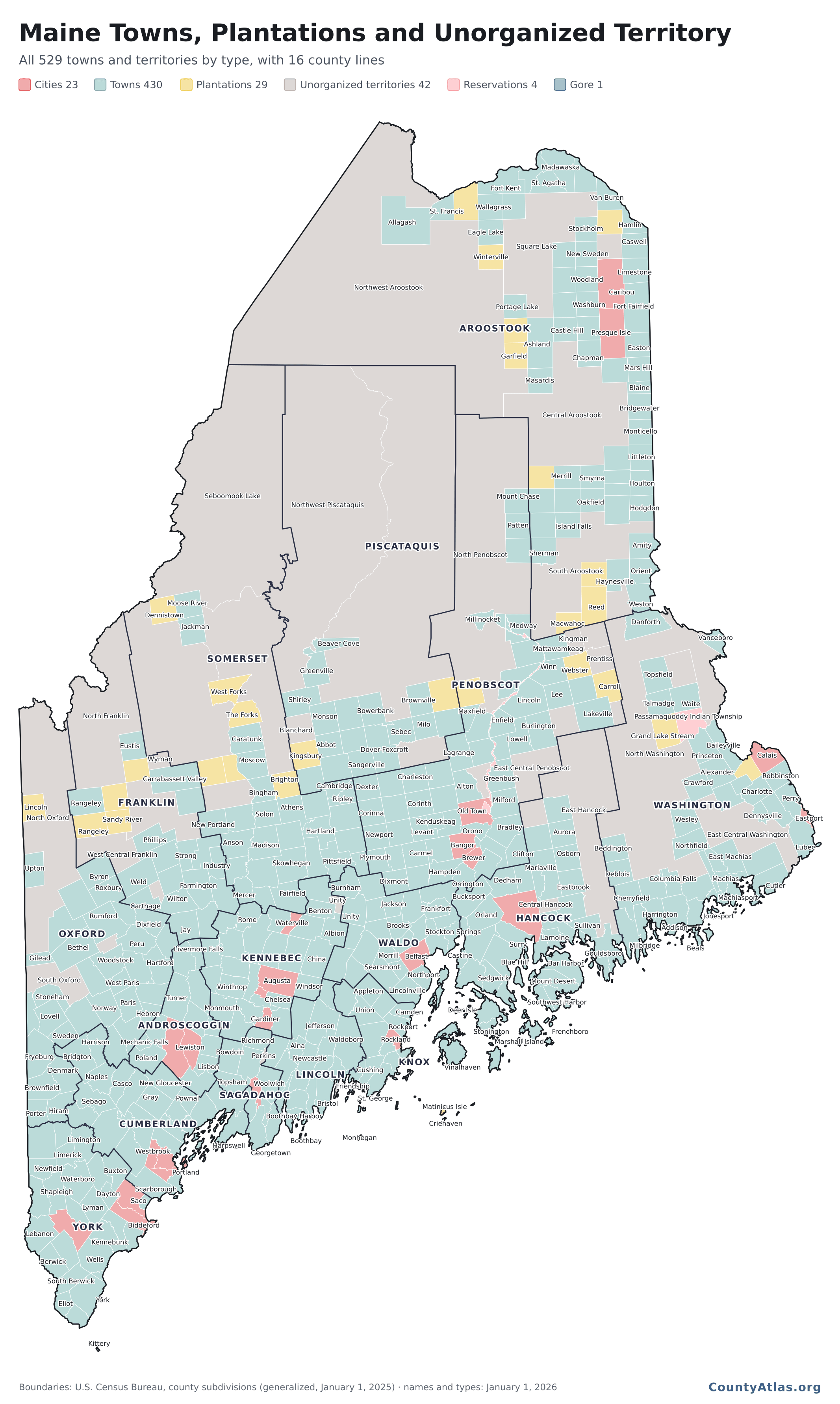
All 529 towns and territories in one image, 2,133 × 3,564 pixels: each filled by its type, with town and county lines and as many town names as fit without overlapping.
You may use this map for any purpose, commercial ones included, as long as the CountyAtlas.org credit printed on it stays with it, or a credit to CountyAtlas with a link sits next to the map where you use it.
Towns, plantations and unorganized territory
Cities, towns and plantations govern themselves; unorganized territory has no local government. The Census Bureau’s geography guide for Maine describes Maine’s towns as functioning governmental units, each governed by a board of selectmen, and its plantations as functioning but not necessarily active governmental units, each governed by a board of assessors. Cities are the incorporated places, each its own county subdivision. Where no town, city or plantation exists, the Census Bureau creates statistical unorganized territories to cover the land: Maine’s 42 hold 47% of its land and 8,355 people, 0.6% of the state, in 2025.
| Type | Count | Land | People |
|---|---|---|---|
| TownsMost populous: Scarborough (24,547) | 430 | 47.3% | 71.1% |
| Unorganized territoriesMost populous: East Central Franklin UT (811) | 42 | 46.7% | 0.6% |
| PlantationsMost populous: Dallas (313) | 29 | 3.4% | 0.2% |
| CitiesMost populous: Portland (69,911) | 23 | 2.5% | 28.0% |
| ReservationsMost populous: Passamaquoddy Indian Township Reservation (763) | 4 | 0.1% | 0.1% |
| GoreHibberts Gore (0) | 1 | 0.0% | 0.0% |
Types as the Census Bureau lists them. Land and people are each type’s share of the state’s land area and of its 1,414,874 residents in the Census Bureau’s estimate for July 1, 2025. The 4 reservation entries are Passamaquoddy Indian Township Reservation, Passamaquoddy Pleasant Point Reservation and Penobscot Indian Island Reservation, the Penobscot one in two counties; the gore is Hibberts Gore, 0.75 square miles in Lincoln County. The median town had 1,293 people in 2025 on 35.2 square miles, the median plantation 64 on 38.3.
Three plantations gone since the 2020 Census
A plantation can vote to give up its government and become unorganized territory. Three that the 2020 Census lists as plantations are unorganized territory in the Census Bureau’s list today, each deorganized by an act of the Legislature: Codyville (Private and Special Law chapter 11 of the 128th Legislature), Magalloway (Private and Special Law chapter 13 of the 129th Legislature) and Drew (Private and Special Law chapter 2 of the 131st Legislature). The Census Bureau now counts Codyville and Drew as unorganized territories of their own, Codyville UT and Drew UT, and Magalloway as part of North Oxford UT; on this page each keeps its 2020 Census count.
Map of Maine cities: all 23, largest first
The cities are the red shapes on the map. Portland is the largest, with 69,911 people in 2025, and Eastport the smallest, with 1,285. The largest town, Scarborough (24,547), is bigger than 18 of the 23 cities.
| # | City | County | People |
|---|---|---|---|
| 1 | Portland | Cumberland | 69,911 |
| 2 | Lewiston | Androscoggin | 38,866 |
| 3 | Bangor | Penobscot | 32,518 |
| 4 | South Portland | Cumberland | 27,007 |
| 5 | Auburn | Androscoggin | 25,441 |
| 6 | Sanford | York | 22,663 |
| 7 | Biddeford | York | 22,399 |
| 8 | Westbrook | Cumberland | 21,565 |
| 9 | Saco | York | 21,159 |
| 10 | Augusta | Kennebec | 19,155 |
| 11 | Waterville | Kennebec | 17,579 |
| 12 | Brewer | Penobscot | 9,636 |
| 13 | Ellsworth | Hancock | 8,862 |
| 14 | Bath | Sagadahoc | 8,835 |
| 15 | Presque Isle | Aroostook | 8,694 |
| 16 | Old Town | Penobscot | 7,589 |
| 17 | Caribou | Aroostook | 7,321 |
| 18 | Rockland | Knox | 7,142 |
| 19 | Belfast | Waldo | 6,988 |
| 20 | Gardiner | Kennebec | 6,206 |
| 21 | Calais | Washington | 3,083 |
| 22 | Hallowell | Kennebec | 2,624 |
| 23 | Eastport | Washington | 1,285 |
List of towns in Maine by county
All 529 cities, towns, plantations and unorganized territories, county by county, with each one’s type, 2025 population and land area. Aroostook County has the most cities, towns and plantations, 64; Piscataquis County has the most unorganized territory, 81% of its land, while Androscoggin County, Cumberland County, Waldo County and York County have none. The same list is a free download: maine-towns.csv.
Androscoggin County: 14 cities and towns
| Town | Type | Population | Land (sq mi) |
|---|---|---|---|
| Auburn | city | 25,441 | 59.3 |
| Durham | town | 4,399 | 38.3 |
| Greene | town | 4,551 | 32.3 |
| Leeds | town | 2,406 | 40.1 |
| Lewiston | city | 38,866 | 34.1 |
| Lisbon | town | 9,919 | 22.8 |
| Livermore | town | 2,229 | 37.6 |
| Livermore Falls | town | 3,229 | 19.7 |
| Mechanic Falls | town | 3,286 | 11.0 |
| Minot | town | 2,866 | 29.6 |
| Poland | town | 6,098 | 42.2 |
| Sabattus | town | 5,397 | 25.7 |
| Turner | town | 6,127 | 59.3 |
| Wales | town | 1,673 | 16.0 |
Aroostook County: 71 towns and territories
| Town | Type | Population | Land (sq mi) |
|---|---|---|---|
| Allagash | town | 234 | 128.6 |
| Amity | town | 250 | 41.7 |
| Ashland | town | 1,186 | 80.4 |
| Bancroft | unorganized territory | 55 | 40.4 |
| Blaine | town | 659 | 18.6 |
| Bridgewater | town | 523 | 38.8 |
| Caribou | city | 7,321 | 79.3 |
| Castle Hill | town | 370 | 35.7 |
| Caswell | town | 283 | 41.3 |
| Central Aroostook | unorganized territory | 162 | 594.4 |
| Chapman | town | 499 | 38.4 |
| Connor | unorganized territory | 428 | 39.3 |
| Crystal | town | 245 | 40.4 |
| Cyr | plantation | 77 | 38.3 |
| Dyer Brook | town | 211 | 38.5 |
| Eagle Lake | town | 754 | 37.3 |
| Easton | town | 1,312 | 38.7 |
| Fort Fairfield | town | 3,285 | 77.0 |
| Fort Kent | town | 4,151 | 54.1 |
| Frenchville | town | 1,019 | 28.5 |
| Garfield | plantation | 78 | 38.3 |
| Glenwood | plantation | 4 | 38.2 |
| Grand Isle | town | 356 | 34.6 |
| Hamlin | town | 162 | 23.3 |
| Hammond | town | 89 | 39.3 |
| Haynesville | town | 99 | 41.4 |
| Hersey | town | 78 | 39.7 |
| Hodgdon | town | 1,296 | 39.8 |
| Houlton | town | 6,056 | 36.7 |
| Island Falls | town | 750 | 36.0 |
| Limestone | town | 1,487 | 40.5 |
| Linneus | town | 950 | 44.2 |
| Littleton | town | 999 | 38.2 |
| Ludlow | town | 444 | 22.0 |
| Macwahoc | plantation | 59 | 29.4 |
| Madawaska | town | 3,846 | 55.6 |
| Mapleton | town | 1,909 | 34.0 |
| Mars Hill | town | 1,318 | 35.1 |
| Masardis | town | 203 | 38.7 |
| Merrill | town | 205 | 37.3 |
| Monticello | town | 725 | 38.2 |
| Moro | plantation | 43 | 35.4 |
| Nashville | plantation | 25 | 35.2 |
| New Canada | town | 308 | 35.8 |
| New Limerick | town | 567 | 18.4 |
| New Sweden | town | 574 | 34.6 |
| Northwest Aroostook | unorganized territory | 9 | 2,617.6 |
| Oakfield | town | 655 | 35.1 |
| Orient | town | 151 | 35.5 |
| Penobscot Indian Island | reservation | 0 | 0.00 |
| Perham | town | 381 | 36.5 |
| Portage Lake | town | 359 | 30.8 |
| Presque Isle | city | 8,694 | 75.8 |
| Reed | plantation | 126 | 59.0 |
| Sherman | town | 802 | 40.0 |
| Smyrna | town | 451 | 35.1 |
| South Aroostook | unorganized territory | 574 | 376.1 |
| Square Lake | unorganized territory | 691 | 394.1 |
| St. Agatha | town | 732 | 29.9 |
| St. Francis | town | 426 | 29.9 |
| St. John | plantation | 261 | 50.3 |
| Stockholm | town | 247 | 34.2 |
| Van Buren | town | 1,985 | 33.8 |
| Wade | town | 232 | 36.1 |
| Wallagrass | town | 510 | 40.1 |
| Washburn | town | 1,499 | 34.2 |
| Westfield | town | 452 | 40.2 |
| Westmanland | town | 79 | 35.6 |
| Weston | town | 241 | 30.6 |
| Winterville | plantation | 192 | 35.6 |
| Woodland | town | 1,206 | 35.2 |
Cumberland County: 28 cities and towns
| Town | Type | Population | Land (sq mi) |
|---|---|---|---|
| Baldwin | town | 1,660 | 35.3 |
| Bridgton | town | 5,965 | 56.9 |
| Brunswick | town | 23,055 | 46.8 |
| Cape Elizabeth | town | 9,827 | 14.9 |
| Casco | town | 3,779 | 31.3 |
| Chebeague Island | town | 398 | 3.6 |
| Cumberland | town | 8,876 | 22.9 |
| Falmouth | town | 12,982 | 29.4 |
| Freeport | town | 8,934 | 34.7 |
| Frye Island | town | 25 | 1.3 |
| Gorham | town | 19,239 | 50.6 |
| Gray | town | 8,676 | 43.3 |
| Harpswell | town | 5,102 | 24.1 |
| Harrison | town | 2,639 | 33.2 |
| Long Island | town | 235 | 1.4 |
| Naples | town | 4,128 | 31.8 |
| New Gloucester | town | 5,964 | 47.1 |
| North Yarmouth | town | 4,424 | 21.2 |
| Portland | city | 69,911 | 21.5 |
| Pownal | town | 1,645 | 22.9 |
| Raymond | town | 4,670 | 33.2 |
| Scarborough | town | 24,547 | 47.7 |
| Sebago | town | 1,995 | 32.8 |
| South Portland | city | 27,007 | 12.0 |
| Standish | town | 11,000 | 59.1 |
| Westbrook | city | 21,565 | 17.2 |
| Windham | town | 19,912 | 46.6 |
| Yarmouth | town | 9,062 | 13.4 |
Franklin County: 26 towns and territories
| Town | Type | Population | Land (sq mi) |
|---|---|---|---|
| Avon | town | 451 | 41.4 |
| Carrabassett Valley | town | 711 | 77.5 |
| Carthage | town | 509 | 33.3 |
| Chesterville | town | 1,378 | 36.2 |
| Coplin | plantation | 132 | 33.0 |
| Dallas | plantation | 313 | 39.0 |
| East Central Franklin | unorganized territory | 811 | 171.1 |
| Eustis | town | 672 | 39.1 |
| Farmington | town | 8,258 | 55.7 |
| Industry | town | 809 | 29.9 |
| Jay | town | 4,639 | 48.4 |
| Kingfield | town | 1,025 | 43.1 |
| New Sharon | town | 1,614 | 46.2 |
| New Vineyard | town | 759 | 35.7 |
| North Franklin | unorganized territory | 40 | 499.0 |
| Phillips | town | 942 | 50.8 |
| Rangeley | plantation | 179 | 40.8 |
| Rangeley | town | 1,336 | 41.5 |
| Sandy River | plantation | 126 | 34.1 |
| South Franklin | unorganized territory | 60 | 12.4 |
| Strong | town | 1,122 | 28.3 |
| Temple | town | 549 | 35.5 |
| Weld | town | 428 | 59.5 |
| West Central Franklin | unorganized territory | 1 | 103.9 |
| Wilton | town | 3,878 | 41.3 |
| Wyman | unorganized territory | 82 | 20.3 |
Hancock County: 41 towns and territories
| Town | Type | Population | Land (sq mi) |
|---|---|---|---|
| Amherst | town | 265 | 39.3 |
| Aurora | town | 93 | 37.7 |
| Bar Harbor | town | 5,352 | 42.2 |
| Blue Hill | town | 2,798 | 62.5 |
| Brooklin | town | 827 | 17.9 |
| Brooksville | town | 933 | 31.1 |
| Bucksport | town | 5,066 | 51.5 |
| Castine | town | 1,310 | 7.8 |
| Central Hancock | unorganized territory | 132 | 15.2 |
| Cranberry Isles | town | 160 | 3.2 |
| Dedham | town | 1,673 | 39.3 |
| Deer Isle | town | 2,132 | 29.7 |
| East Hancock | unorganized territory | 79 | 443.1 |
| Eastbrook | town | 431 | 33.4 |
| Ellsworth | city | 8,862 | 79.3 |
| Franklin | town | 1,666 | 36.5 |
| Frenchboro | town | 31 | 4.8 |
| Gouldsboro | town | 1,769 | 46.3 |
| Great Pond | town | 61 | 37.8 |
| Hancock | town | 2,593 | 30.0 |
| Lamoine | town | 1,811 | 17.8 |
| Mariaville | town | 502 | 38.7 |
| Marshall Island | unorganized territory | 0 | 1.6 |
| Mount Desert | town | 2,214 | 36.9 |
| Northwest Hancock | unorganized territory | 4 | 40.9 |
| Orland | town | 2,224 | 47.0 |
| Osborn | town | 67 | 35.2 |
| Otis | town | 667 | 24.8 |
| Penobscot | town | 1,159 | 39.9 |
| Sedgwick | town | 1,203 | 27.0 |
| Sorrento | town | 279 | 4.0 |
| Southwest Harbor | town | 1,873 | 13.5 |
| Stonington | town | 1,058 | 9.8 |
| Sullivan | town | 1,281 | 26.7 |
| Surry | town | 1,692 | 37.0 |
| Swans Island | town | 356 | 12.4 |
| Tremont | town | 1,552 | 16.8 |
| Trenton | town | 1,656 | 18.2 |
| Verona Island | town | 515 | 6.2 |
| Waltham | town | 344 | 29.7 |
| Winter Harbor | town | 481 | 14.4 |
Kennebec County: 30 towns and territories
| Town | Type | Population | Land (sq mi) |
|---|---|---|---|
| Albion | town | 2,092 | 38.8 |
| Augusta | city | 19,155 | 55.1 |
| Belgrade | town | 3,541 | 43.2 |
| Benton | town | 2,821 | 28.4 |
| Chelsea | town | 2,848 | 19.5 |
| China | town | 4,636 | 49.9 |
| Clinton | town | 3,378 | 43.9 |
| Farmingdale | town | 3,000 | 11.2 |
| Fayette | town | 1,277 | 29.2 |
| Gardiner | city | 6,206 | 15.7 |
| Hallowell | city | 2,624 | 5.9 |
| Litchfield | town | 3,797 | 37.4 |
| Manchester | town | 2,492 | 21.4 |
| Monmouth | town | 4,252 | 34.0 |
| Mount Vernon | town | 1,843 | 37.9 |
| Oakland | town | 6,361 | 25.7 |
| Pittston | town | 3,418 | 32.2 |
| Randolph | town | 1,780 | 2.1 |
| Readfield | town | 2,730 | 29.2 |
| Rome | town | 1,184 | 25.4 |
| Sidney | town | 4,929 | 42.2 |
| Unity | unorganized territory | 38 | 10.4 |
| Vassalboro | town | 4,647 | 44.3 |
| Vienna | town | 615 | 24.3 |
| Waterville | city | 17,579 | 13.5 |
| Wayne | town | 1,167 | 19.3 |
| West Gardiner | town | 3,678 | 24.6 |
| Windsor | town | 2,758 | 34.6 |
| Winslow | town | 8,063 | 36.8 |
| Winthrop | town | 6,158 | 31.2 |
Knox County: 20 towns and territories
| Town | Type | Population | Land (sq mi) |
|---|---|---|---|
| Appleton | town | 1,469 | 32.7 |
| Camden | town | 5,204 | 18.2 |
| Criehaven | unorganized territory | 3 | 0.53 |
| Cushing | town | 1,482 | 19.2 |
| Friendship | town | 1,159 | 14.1 |
| Hope | town | 1,737 | 22.0 |
| Isle au Haut | town | 84 | 12.5 |
| Matinicus Isle | plantation | 50 | 2.4 |
| Muscle Ridge Islands | unorganized territory | 8 | 0.95 |
| North Haven | town | 432 | 11.4 |
| Owls Head | town | 1,494 | 8.9 |
| Rockland | city | 7,142 | 12.8 |
| Rockport | town | 3,628 | 21.6 |
| South Thomaston | town | 1,520 | 11.4 |
| St. George | town | 2,595 | 25.0 |
| Thomaston | town | 2,751 | 10.9 |
| Union | town | 2,444 | 32.2 |
| Vinalhaven | town | 1,254 | 23.5 |
| Warren | town | 5,099 | 46.5 |
| Washington | town | 1,562 | 38.0 |
Lincoln County: 21 towns and territories
| Town | Type | Population | Land (sq mi) |
|---|---|---|---|
| Alna | town | 732 | 20.9 |
| Boothbay | town | 3,155 | 22.0 |
| Boothbay Harbor | town | 2,103 | 5.7 |
| Bremen | town | 842 | 16.5 |
| Bristol | town | 2,969 | 34.0 |
| Damariscotta | town | 2,296 | 12.4 |
| Dresden | town | 1,792 | 30.5 |
| Edgecomb | town | 1,214 | 18.1 |
| Hibberts | gore | 0 | 0.75 |
| Jefferson | town | 2,728 | 52.6 |
| Louds Island | unorganized territory | 2 | 1.6 |
| Monhegan | plantation | 62 | 0.85 |
| Newcastle | town | 1,915 | 29.1 |
| Nobleboro | town | 1,909 | 18.9 |
| Somerville | town | 623 | 21.9 |
| South Bristol | town | 1,137 | 13.1 |
| Southport | town | 634 | 5.4 |
| Waldoboro | town | 5,324 | 71.5 |
| Westport Island | town | 750 | 8.8 |
| Whitefield | town | 2,410 | 46.8 |
| Wiscasset | town | 3,998 | 24.6 |
Oxford County: 38 towns and territories
| Town | Type | Population | Land (sq mi) |
|---|---|---|---|
| Andover | town | 887 | 57.4 |
| Bethel | town | 2,751 | 64.6 |
| Brownfield | town | 1,704 | 44.5 |
| Buckfield | town | 2,114 | 37.5 |
| Byron | town | 104 | 51.8 |
| Canton | town | 1,123 | 29.1 |
| Denmark | town | 1,253 | 46.1 |
| Dixfield | town | 2,396 | 41.3 |
| Fryeburg | town | 3,576 | 58.3 |
| Gilead | town | 198 | 18.9 |
| Greenwood | town | 764 | 41.7 |
| Hanover | town | 304 | 7.0 |
| Hartford | town | 1,264 | 43.9 |
| Hebron | town | 1,289 | 22.4 |
| Hiram | town | 1,712 | 37.5 |
| Lincoln | plantation | 40 | 32.7 |
| Lovell | town | 1,155 | 43.1 |
| Mexico | town | 2,779 | 23.3 |
| Milton | unorganized territory | 152 | 14.9 |
| Newry | town | 429 | 61.5 |
| North Oxford | unorganized territory | 64 | 557.2 |
| Norway | town | 5,349 | 45.0 |
| Otisfield | town | 1,893 | 39.9 |
| Oxford | town | 4,449 | 38.7 |
| Paris | town | 5,409 | 40.8 |
| Peru | town | 1,501 | 46.7 |
| Porter | town | 1,652 | 31.5 |
| Roxbury | town | 364 | 42.9 |
| Rumford | town | 6,025 | 68.6 |
| South Oxford | unorganized territory | 592 | 97.1 |
| Stoneham | town | 276 | 33.8 |
| Stow | town | 451 | 24.2 |
| Sumner | town | 1,006 | 44.3 |
| Sweden | town | 424 | 28.8 |
| Upton | town | 69 | 39.5 |
| Waterford | town | 1,632 | 50.3 |
| West Paris | town | 1,773 | 24.2 |
| Woodstock | town | 1,423 | 45.7 |
Penobscot County: 67 towns and territories
| Town | Type | Population | Land (sq mi) |
|---|---|---|---|
| Alton | town | 842 | 42.3 |
| Argyle | unorganized territory | 259 | 26.6 |
| Bangor | city | 32,518 | 34.3 |
| Bradford | town | 1,247 | 41.2 |
| Bradley | town | 1,581 | 49.5 |
| Brewer | city | 9,636 | 15.2 |
| Burlington | town | 450 | 54.0 |
| Carmel | town | 3,031 | 36.7 |
| Carroll | plantation | 140 | 44.0 |
| Charleston | town | 1,644 | 40.6 |
| Chester | town | 553 | 45.8 |
| Clifton | town | 875 | 34.5 |
| Corinna | town | 2,261 | 38.7 |
| Corinth | town | 3,139 | 40.3 |
| Dexter | town | 3,874 | 35.1 |
| Dixmont | town | 1,215 | 36.3 |
| Drew | unorganized territory | 26 | 38.0 |
| East Central Penobscot | unorganized territory | 312 | 114.5 |
| East Millinocket | town | 1,567 | 7.1 |
| Eddington | town | 2,254 | 25.0 |
| Edinburg | town | 136 | 35.0 |
| Enfield | town | 1,444 | 27.7 |
| Etna | town | 1,245 | 24.7 |
| Exeter | town | 1,002 | 38.6 |
| Garland | town | 1,039 | 37.7 |
| Glenburn | town | 4,825 | 27.2 |
| Greenbush | town | 1,531 | 43.8 |
| Hampden | town | 8,078 | 37.9 |
| Hermon | town | 6,982 | 35.9 |
| Holden | town | 3,438 | 31.3 |
| Howland | town | 1,166 | 34.9 |
| Hudson | town | 1,483 | 37.6 |
| Kenduskeag | town | 1,418 | 16.8 |
| Kingman | unorganized territory | 140 | 25.0 |
| Lagrange | town | 647 | 49.5 |
| Lakeville | town | 105 | 58.2 |
| Lee | town | 923 | 38.7 |
| Levant | town | 3,289 | 30.1 |
| Lincoln | town | 4,971 | 67.8 |
| Lowell | town | 388 | 38.3 |
| Mattawamkeag | town | 607 | 37.7 |
| Maxfield | town | 99 | 18.9 |
| Medway | town | 1,197 | 41.0 |
| Milford | town | 3,117 | 45.6 |
| Millinocket | town | 4,095 | 15.9 |
| Mount Chase | town | 190 | 36.6 |
| Newburgh | town | 1,735 | 31.0 |
| Newport | town | 3,192 | 29.5 |
| North Penobscot | unorganized territory | 419 | 1,051.7 |
| Old Town | city | 7,589 | 38.8 |
| Orono | town | 12,421 | 18.2 |
| Orrington | town | 3,912 | 25.0 |
| Passadumkeag | town | 349 | 22.9 |
| Patten | town | 900 | 38.2 |
| Penobscot Indian Island | reservation | 377 | 7.6 |
| Plymouth | town | 1,328 | 29.7 |
| Prentiss | unorganized territory | 174 | 38.2 |
| Seboeis | plantation | 39 | 40.0 |
| Springfield | town | 390 | 38.5 |
| Stacyville | town | 375 | 39.5 |
| Stetson | town | 1,243 | 35.0 |
| Twombly Ridge | unorganized territory | 0 | 44.0 |
| Veazie | town | 1,864 | 3.0 |
| Webster | plantation | 64 | 36.6 |
| Whitney | unorganized territory | 8 | 10.9 |
| Winn | town | 405 | 43.7 |
| Woodville | town | 204 | 42.7 |
Piscataquis County: 22 towns and territories
| Town | Type | Population | Land (sq mi) |
|---|---|---|---|
| Abbot | town | 638 | 34.5 |
| Beaver Cove | town | 134 | 31.9 |
| Blanchard | unorganized territory | 91 | 44.3 |
| Bowerbank | town | 137 | 41.9 |
| Brownville | town | 1,153 | 43.8 |
| Dover-Foxcroft | town | 4,463 | 67.8 |
| Greenville | town | 1,743 | 42.3 |
| Guilford | town | 1,285 | 34.9 |
| Kingsbury | plantation | 30 | 44.1 |
| Lake View | plantation | 152 | 40.9 |
| Medford | town | 235 | 42.3 |
| Milo | town | 2,350 | 33.0 |
| Monson | town | 642 | 46.8 |
| Northeast Piscataquis | unorganized territory | 308 | 1,708.1 |
| Northwest Piscataquis | unorganized territory | 141 | 1,372.4 |
| Parkman | town | 759 | 45.2 |
| Sangerville | town | 1,336 | 38.4 |
| Sebec | town | 676 | 36.7 |
| Shirley | town | 275 | 53.3 |
| Southeast Piscataquis | unorganized territory | 493 | 75.1 |
| Wellington | town | 232 | 39.9 |
| Willimantic | town | 136 | 43.2 |
Sagadahoc County: 11 towns and territories
| Town | Type | Population | Land (sq mi) |
|---|---|---|---|
| Arrowsic | town | 499 | 7.7 |
| Bath | city | 8,835 | 9.1 |
| Bowdoin | town | 3,254 | 43.5 |
| Bowdoinham | town | 3,210 | 34.4 |
| Georgetown | town | 1,101 | 18.6 |
| Perkins | unorganized territory | 0 | 2.3 |
| Phippsburg | town | 2,232 | 28.8 |
| Richmond | town | 3,609 | 30.4 |
| Topsham | town | 9,982 | 32.2 |
| West Bath | town | 1,970 | 11.9 |
| Woolwich | town | 3,287 | 35.1 |
Somerset County: 37 towns and territories
| Town | Type | Population | Land (sq mi) |
|---|---|---|---|
| Anson | town | 2,333 | 47.5 |
| Athens | town | 955 | 43.6 |
| Bingham | town | 833 | 33.9 |
| Brighton | plantation | 61 | 39.3 |
| Cambridge | town | 460 | 19.3 |
| Canaan | town | 2,219 | 41.2 |
| Caratunk | town | 82 | 52.3 |
| Central Somerset | unorganized territory | 339 | 76.7 |
| Cornville | town | 1,378 | 40.7 |
| Dennistown | plantation | 60 | 38.6 |
| Detroit | town | 929 | 20.2 |
| Embden | town | 958 | 39.6 |
| Fairfield | town | 6,537 | 53.7 |
| Harmony | town | 829 | 38.7 |
| Hartland | town | 1,890 | 37.1 |
| Highland | plantation | 54 | 42.2 |
| Jackman | town | 799 | 41.3 |
| Madison | town | 4,888 | 51.9 |
| Mercer | town | 713 | 26.7 |
| Moose River | town | 186 | 40.1 |
| Moscow | town | 492 | 46.2 |
| New Portland | town | 766 | 43.9 |
| Norridgewock | town | 3,304 | 50.0 |
| Northeast Somerset | unorganized territory | 367 | 483.9 |
| Northwest Somerset | unorganized territory | 39 | 656.8 |
| Palmyra | town | 2,077 | 40.2 |
| Pittsfield | town | 3,935 | 48.2 |
| Pleasant Ridge | plantation | 86 | 22.1 |
| Ripley | town | 487 | 24.6 |
| Seboomook Lake | unorganized territory | 13 | 1,401.1 |
| Skowhegan | town | 8,676 | 58.8 |
| Smithfield | town | 953 | 19.9 |
| Solon | town | 1,008 | 39.6 |
| St. Albans | town | 2,176 | 44.8 |
| Starks | town | 632 | 31.5 |
| The Forks | plantation | 48 | 39.6 |
| West Forks | plantation | 58 | 48.7 |
Waldo County: 26 cities and towns
| Town | Type | Population | Land (sq mi) |
|---|---|---|---|
| Belfast | city | 6,988 | 34.1 |
| Belmont | town | 1,021 | 13.6 |
| Brooks | town | 1,023 | 24.7 |
| Burnham | town | 1,108 | 38.9 |
| Frankfort | town | 1,248 | 24.6 |
| Freedom | town | 745 | 21.5 |
| Islesboro | town | 596 | 14.6 |
| Jackson | town | 614 | 25.3 |
| Knox | town | 811 | 29.0 |
| Liberty | town | 945 | 26.0 |
| Lincolnville | town | 2,433 | 37.3 |
| Monroe | town | 941 | 38.9 |
| Montville | town | 1,025 | 42.7 |
| Morrill | town | 1,031 | 16.6 |
| Northport | town | 1,640 | 23.8 |
| Palermo | town | 1,636 | 40.6 |
| Prospect | town | 703 | 18.1 |
| Searsmont | town | 1,484 | 37.7 |
| Searsport | town | 2,737 | 28.7 |
| Stockton Springs | town | 1,593 | 19.6 |
| Swanville | town | 1,435 | 19.7 |
| Thorndike | town | 802 | 25.3 |
| Troy | town | 1,116 | 34.9 |
| Unity | town | 2,307 | 39.4 |
| Waldo | town | 873 | 19.3 |
| Winterport | town | 3,838 | 35.5 |
Washington County: 48 towns and territories
| Town | Type | Population | Land (sq mi) |
|---|---|---|---|
| Addison | town | 1,193 | 42.4 |
| Alexander | town | 519 | 40.1 |
| Baileyville | town | 1,314 | 37.3 |
| Baring | plantation | 197 | 20.8 |
| Beals | town | 453 | 5.6 |
| Beddington | town | 61 | 34.6 |
| Calais | city | 3,083 | 34.3 |
| Charlotte | town | 337 | 31.0 |
| Cherryfield | town | 1,093 | 44.5 |
| Codyville | unorganized territory | 14 | 54.7 |
| Columbia | town | 435 | 36.3 |
| Columbia Falls | town | 484 | 24.5 |
| Cooper | town | 169 | 30.7 |
| Crawford | town | 93 | 34.5 |
| Cutler | town | 533 | 46.8 |
| Danforth | town | 583 | 54.0 |
| Deblois | town | 76 | 35.8 |
| Dennysville | town | 312 | 14.9 |
| East Central Washington | unorganized territory | 721 | 207.2 |
| East Machias | town | 1,341 | 34.9 |
| Eastport | city | 1,285 | 3.6 |
| Grand Lake Stream | plantation | 128 | 44.0 |
| Harrington | town | 998 | 21.1 |
| Jonesboro | town | 607 | 36.6 |
| Jonesport | town | 1,244 | 28.5 |
| Lubec | town | 1,237 | 33.2 |
| Machias | town | 2,078 | 13.9 |
| Machiasport | town | 1,004 | 21.4 |
| Marshfield | town | 529 | 17.0 |
| Meddybemps | town | 136 | 13.1 |
| Milbridge | town | 1,316 | 24.2 |
| North Washington | unorganized territory | 504 | 920.9 |
| Northfield | town | 177 | 43.6 |
| Passamaquoddy Indian Township | reservation | 763 | 37.5 |
| Passamaquoddy Pleasant Point | reservation | 686 | 0.56 |
| Pembroke | town | 778 | 27.4 |
| Perry | town | 798 | 29.3 |
| Princeton | town | 749 | 36.6 |
| Robbinston | town | 554 | 28.2 |
| Roque Bluffs | town | 316 | 10.4 |
| Steuben | town | 1,181 | 43.0 |
| Talmadge | town | 72 | 37.8 |
| Topsfield | town | 180 | 50.1 |
| Vanceboro | town | 103 | 20.1 |
| Waite | town | 65 | 44.0 |
| Wesley | town | 122 | 49.9 |
| Whiting | town | 505 | 46.7 |
| Whitneyville | town | 208 | 14.9 |
York County: 29 cities and towns
| Town | Type | Population | Land (sq mi) |
|---|---|---|---|
| Acton | town | 2,735 | 37.8 |
| Alfred | town | 3,188 | 27.3 |
| Arundel | town | 4,596 | 23.9 |
| Berwick | town | 8,436 | 37.5 |
| Biddeford | city | 22,399 | 30.1 |
| Buxton | town | 8,681 | 40.5 |
| Cornish | town | 1,602 | 22.2 |
| Dayton | town | 2,182 | 17.9 |
| Eliot | town | 7,643 | 19.8 |
| Hollis | town | 5,003 | 32.0 |
| Kennebunk | town | 12,152 | 35.1 |
| Kennebunkport | town | 3,717 | 20.6 |
| Kittery | town | 11,420 | 17.8 |
| Lebanon | town | 6,801 | 55.0 |
| Limerick | town | 3,575 | 27.1 |
| Limington | town | 4,173 | 42.0 |
| Lyman | town | 4,713 | 39.0 |
| Newfield | town | 1,693 | 32.3 |
| North Berwick | town | 5,355 | 38.0 |
| Ogunquit | town | 1,606 | 4.1 |
| Old Orchard Beach | town | 9,533 | 7.4 |
| Parsonsfield | town | 1,837 | 58.9 |
| Saco | city | 21,159 | 38.6 |
| Sanford | city | 22,663 | 47.8 |
| Shapleigh | town | 3,025 | 38.7 |
| South Berwick | town | 7,941 | 32.1 |
| Waterboro | town | 8,219 | 55.3 |
| Wells | town | 12,094 | 57.7 |
| York | town | 14,293 | 54.7 |
Population: the Census Bureau’s estimate for July 1, 2025; the CSV and each town’s card on the map also give the 2020 Census count. Land: square miles of land, water left out. Marshall Island UT, Perkins UT and Twombly Ridge UT had no residents in 2020.
Largest and smallest towns in Maine
By population, Portland is the largest city, with 69,911 people in the Census Bureau’s 2025 estimate, and Scarborough the largest town (24,547). By land, Allagash in Aroostook County is the largest town at 128.6 square miles; Northwest Aroostook UT, unorganized territory in Aroostook County, covers 2,617.6. The smallest town is Frye Island in Cumberland County, with 25 residents, and the smallest plantation Glenwood in Aroostook County, with 4. The smallest by land is Monhegan, a plantation of 0.85 square miles in Lincoln County. Of the 482 cities, towns and plantations, 197 have fewer than 1,000 people.
| # | Town | County | People |
|---|---|---|---|
| 1 | Portland | Cumberland | 69,911 |
| 2 | Lewiston | Androscoggin | 38,866 |
| 3 | Bangor | Penobscot | 32,518 |
| 4 | South Portland | Cumberland | 27,007 |
| 5 | Auburn | Androscoggin | 25,441 |
| 6 | Scarborough | Cumberland | 24,547 |
| 7 | Brunswick | Cumberland | 23,055 |
| 8 | Sanford | York | 22,663 |
| 9 | Biddeford | York | 22,399 |
| 10 | Westbrook | Cumberland | 21,565 |
| # | Town | County | People |
|---|---|---|---|
| 1 | Glenwood | Aroostook | 4 |
| 2 | Frye Island | Cumberland | 25 |
| 3 | Nashville | Aroostook | 25 |
| 4 | Kingsbury | Piscataquis | 30 |
| 5 | Frenchboro | Hancock | 31 |
| 6 | Seboeis | Penobscot | 39 |
| 7 | Lincoln Plantation | Oxford | 40 |
| 8 | Moro | Aroostook | 43 |
| 9 | The Forks | Somerset | 48 |
| 10 | Matinicus Isle | Knox | 50 |
| # | Town | County | Sq mi |
|---|---|---|---|
| 1 | Allagash | Aroostook | 128.6 |
| 2 | Ashland | Aroostook | 80.4 |
| 3 | Ellsworth | Hancock | 79.3 |
| 4 | Caribou | Aroostook | 79.3 |
| 5 | Carrabassett Valley | Franklin | 77.5 |
| 6 | Fort Fairfield | Aroostook | 77.0 |
| 7 | Presque Isle | Aroostook | 75.8 |
| 8 | Waldoboro | Lincoln | 71.5 |
| 9 | Rumford | Oxford | 68.6 |
| 10 | Lincoln Town | Penobscot | 67.8 |
| # | Area | County | Sq mi |
|---|---|---|---|
| 1 | Northwest Aroostook UT | Aroostook | 2,617.6 |
| 2 | Northeast Piscataquis UT | Piscataquis | 1,708.1 |
| 3 | Seboomook Lake UT | Somerset | 1,401.1 |
| 4 | Northwest Piscataquis UT | Piscataquis | 1,372.4 |
| 5 | North Penobscot UT | Penobscot | 1,051.7 |
| 6 | North Washington UT | Washington | 920.9 |
| 7 | Northwest Somerset UT | Somerset | 656.8 |
| 8 | Central Aroostook UT | Aroostook | 594.4 |
| 9 | North Oxford UT | Oxford | 557.2 |
| 10 | North Franklin UT | Franklin | 499.0 |
Fastest-growing and shrinking towns since 2020
From April 2020 to July 1, 2025, 381 of the 524 towns and territories with residents in April 2020 grew, 96 shrank and 47 held steady, while Maine went from 1,363,218 to 1,414,874 residents. Among towns of 1,000 people or more, Greenville in Piscataquis County grew fastest, +21.2%, and Milbridge in Washington County lost the largest share, −3.9%.
| # | Town | County | Change |
|---|---|---|---|
| 1 | Greenville | Piscataquis | +21.2% |
| 2 | Pittston | Kennebec | +19.0% |
| 3 | Eliot | York | +13.7% |
| 4 | Kittery | York | +13.4% |
| 5 | Limerick | York | +12.1% |
| 6 | Levant | Penobscot | +12.0% |
| 7 | Hartland | Somerset | +11.2% |
| 8 | Orono | Penobscot | +11.0% |
| 9 | Scarborough | Cumberland | +11.0% |
| 10 | Bridgton | Cumberland | +10.2% |
| # | Town | County | Change |
|---|---|---|---|
| 1 | Milbridge | Washington | −3.9% |
| 2 | Mars Hill | Aroostook | −3.2% |
| 3 | Frenchville | Aroostook | −3.0% |
| 4 | Deer Isle | Hancock | −2.7% |
| 5 | Vinalhaven | Knox | −2.7% |
| 6 | Van Buren | Aroostook | −2.7% |
| 7 | Limestone | Aroostook | −2.5% |
| 8 | Washington | Knox | −2.0% |
| 9 | Washburn | Aroostook | −1.8% |
| 10 | Cushing | Knox | −1.5% |
Change: from the Census Bureau’s estimates base for April 1, 2020 to its estimate for July 1, 2025. The tables leave out towns under 1,000 people, where a handful of residents would swing the percentage.
Maine towns: common questions
How many towns are in Maine?
430 towns, plus 23 cities and 29 plantations: 482 municipalities in 16 counties, in the Census Bureau’s list as of January 1, 2026. The rest of the state is 42 unorganized territories, 4 reservation entries and a gore.
What is a plantation in Maine?
A local government smaller than a town: the Census Bureau describes Maine’s plantations as functioning but not necessarily active governmental units, each governed by a board of assessors. There are 29; the largest is Dallas in Franklin County, with 313 people in 2025, and the smallest Glenwood, with 4.
What is the unorganized territory in Maine?
Land outside every town, city and plantation, with no local government of its own. The Census Bureau maps it as 42 unorganized territories (“UT” in their names) covering 47% of Maine’s land, home to 8,355 people in 2025. Piscataquis County has the most of it, 81% of the county’s land.
What are the biggest towns in Maine?
By population, the five largest are Portland (69,911), Lewiston (38,866), Bangor (32,518), South Portland (27,007) and Auburn (25,441) in the Census Bureau’s 2025 estimate; all five are cities. The largest town is Scarborough in Cumberland County, with 24,547.
What is the smallest town in Maine?
By population, Frye Island in Cumberland County: 25 residents in the Census Bureau’s 2025 estimate (32 in the 2020 Census). Counting plantations, Glenwood in Aroostook County is smaller, with 4. By land, Monhegan in Lincoln County, at 0.85 square miles.
Which Maine county has the most towns?
Aroostook County, with 64 cities, towns and plantations, and 6 unorganized territories besides. Sagadahoc County has the fewest, 10.
What town am I in?
Press Find my town on the map above: it asks the Census Bureau which town, plantation or unorganized territory your location is in and shows it. For an address, or anywhere outside Maine, use the township lookup.
Sources & vintages
- Source: U.S. Census Bureau, TIGERweb county subdivision boundaries, current vintage — retrieved Nov 2026
- Source: U.S. Census Bureau, Vintage 2025 population estimates for incorporated places and minor civil divisions — retrieved Nov 2026
- Source: U.S. Census Bureau, 2020 Census population of county subdivisions — retrieved Nov 2026
- Source: U.S. Census Bureau, generalized county subdivision boundaries (1:500,000) — retrieved Nov 2026
Names, types and land areas are the Census Bureau’s county subdivisions as of January 1, 2026. Populations are the Census Bureau’s estimates for July 1, 2025 (Vintage 2025), from its city and town totals, beside the 2020 Census counts. The descriptions of towns and plantations come from the Census Bureau’s geography guide for Maine, the deorganizations from the Maine Legislature’s acts, linked above. The map’s shapes are the Census Bureau’s generalized boundaries as of January 1, 2025, and from zoom 10 its exact current lines. Related: what township am I in · county lines map · Maine county map · Massachusetts town map · Connecticut town map · methodology.